1890s Maps of Monroe County, New York
Explore 7 historic maps of Monroe County from the 1890s. These maps offer a rare glimpse into what life looked like during the 1890s — showing old roads, neighborhoods, homes, and landmarks that have changed or disappeared over time.
Whether you're researching your family's past, planning a metal detecting trip, or studying how Monroe County's landscape evolved across the 1890s, these high-resolution maps are a powerful tool for exploring the history of this region.
- Focus on a specific era: All maps on this page are from the 1890s, giving you a focused view of this time period.
- See what’s changed: Compare century-old streets, trails, and buildings to today's modern landscape using overlays and satellite layers.
- Research with precision: Use these maps for genealogy, historical research, land use analysis, or educational projects.
- View, download, or print: Maps are fully viewable online in high resolution, and can be downloaded or printed for your own records.
Start exploring Monroe County's history through authentic maps from the 1890s. This is your window into the past.
Monroe County, NY maps
(7)- 1895 Map of Rochester
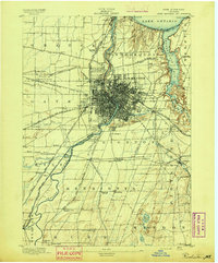 1895 Rochester1895 Print · USGSRochester and its surrounding townships thrived at the end of the century as a hub of canal traffic and steam rail. Genealogists can trace family roots in early settlements like Barnard Crossing, South Greece Station, and the lakeside resort of Glen Haven.
 - 1895 Map of Ontario Beach
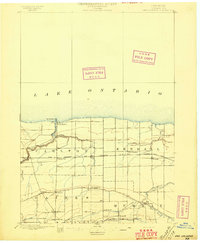
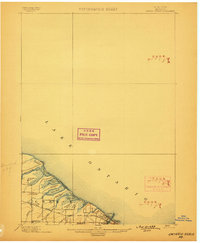
 1895 Ontario Beach1895 Print · USGSMonroe County's lakefront comes alive in the mid-1890s, capturing the early resort and transit infrastructure of the town of Greece. Trace the old Electric R. R. to Ontario Beach or locate nineteenth-century landmarks like Genesee L.H. and Frisbee Hill.
 - 1897 Map of Oak Orchard
 1897 Oak Orchard1897 Print · USGSOrleans County at the close of the nineteenth century is defined by the parallel transit corridors of the Erie Canal and the Great Lakes rail lines. Genealogists and historians can trace the early layout of Point Breeze, find forgotten stops like Carlton Sta., and follow the historic path of Ridge Road.6 unique versions available
 - 1898 Map of Rochester
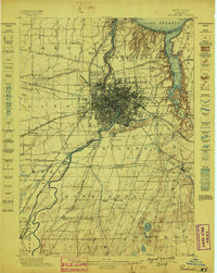 1898 Rochester1898 Print · USGSMonroe County was a burgeoning hub of rail and water commerce in the 1890s, anchored by a dense industrial core. Researchers can trace the original path of the Erie Canal and locate long-lost railway depots at South Greece Station and Henrietta Station.5 unique versions available
 - 1899 Map of Hamlin
 1899 Hamlin1899 Print · USGSThe northern shore of Monroe County appears here in the late nineteenth century, just as the rail lines were solidifying the region's agricultural character. Researchers can trace the early layout of Hilton and Hamlin or locate family roots in the Irish Settlement.4 unique versions available
 - 1899 Map of Ontario Beach
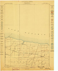
 1899 Ontario Beach1899 Print · USGSThe Lake Ontario shoreline near the turn of the century shows a unique era of transit and coastal settlement in Monroe County. Trace the route of the Grand View Beach Electric Railroad past Cranberry Pond to the waterfront at Ontario Beach.3 unique versions available
 - 1899 Map of Brockport
 1899 Brockport1899 Print · USGSMonroe and Genesee Counties are captured here at the close of the nineteenth century as the industrial power of the Erie Canal and five different railroads reshaped the landscape. Genealogists and local historians can trace family-named sites and vanished hamlets like Moreton Farm, Hinkleyville, and Stone Church.8 unique versions available
End of results
Showing maps 1-7 of 7
Top cities of Monroe County
- Rochester historical maps
- Greece historical maps
- Irondequoit historical maps
- Perinton historical maps
- Henrietta historical maps
- Webster historical maps
See more
Frequently asked questions
- What are the different types of historical maps available for Monroe County?
- What is the oldest map of Monroe County?
- Where can I purchase historical maps of Monroe County for my home or office?
- Where can I download high-res historical maps of Monroe County?
- Are there historical topographic maps available for Monroe County?
- Is there historical aerial imagery available for Monroe County?
- Where are historical maps of Monroe County sourced from?