1940s Maps of Monroe County, New York
Explore 7 historic maps of Monroe County from the 1940s. These maps offer a rare glimpse into what life looked like during the 1940s — showing old roads, neighborhoods, homes, and landmarks that have changed or disappeared over time.
Whether you're researching your family's past, planning a metal detecting trip, or studying how Monroe County's landscape evolved across the 1940s, these high-resolution maps are a powerful tool for exploring the history of this region.
- Focus on a specific era: All maps on this page are from the 1940s, giving you a focused view of this time period.
- See what’s changed: Compare century-old streets, trails, and buildings to today's modern landscape using overlays and satellite layers.
- Research with precision: Use these maps for genealogy, historical research, land use analysis, or educational projects.
- View, download, or print: Maps are fully viewable online in high resolution, and can be downloaded or printed for your own records.
Start exploring Monroe County's history through authentic maps from the 1940s. This is your window into the past.
Monroe County, NY maps
(7)- 1942 Map of Ontario
 1942 Ontario1942 Print · USGSWayne County just before the mid-century shows a landscape of busy hamlets and extensive orchards linked by a network of numbered schools. Researchers can trace the New York Central Railroad corridor and locate ancestral sites like Dixon Cem and Fruitland.
 - 1942 Map of Victor
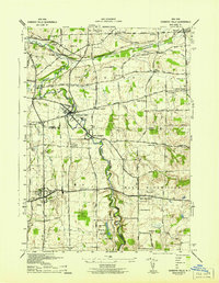
 1942 Victor1942 Print · USGSOntario County during the early 1940s reveals a landscape defined by the convergence of the Lehigh Valley and New York Central railroads. You can trace early family settlements and rural centers like Ionia, East Bloomfield, and the historic burial grounds at French Cem or Dibble Cem.
 - 1942 Map of Honeoye Falls
 1942 Honeoye Falls1942 Print · USGSWestern New York at the onset of the 1940s reveals a landscape of thriving rail hubs and rural crossroads villages. Genealogists can trace family names through landmarks like Quaker Cem or Graves Cem and locate historic rural schools such as School No 10.
 - 1943 Map of Fairport
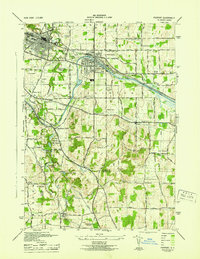 1943 Fairport1943 Print · USGSFairport and the surrounding Perinton countryside are captured here during the Second World War as the canal and rail networks remained vital. Genealogists can locate numerous numbered rural schools and historic burial grounds like Parks Cem and St Marys Cem.
 - 1944 Map of Churchville
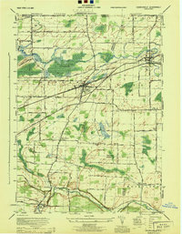 1944 Churchville1944 Print · USGSMonroe and Genesee counties are captured here in the mid-1940s, showing a landscape defined by the New York Central System and Bergen Swamp Wild Life Sanctuary. Researchers can trace rural school districts like School No 9 and settlements at Stone Church or Beulah.
 - 1944 Map of Le Roy
 1944 Le Roy1944 Print · USGSLe Roy and its surrounding townships are shown at the height of the steam-to-diesel rail era, where three major lines intersect. Genealogists can locate family landmarks such as Machpelah Cemetery, Union Corners, and many rural schoolhouses like School No 7.
 - 1949 Map of Kendall, 1956 Print
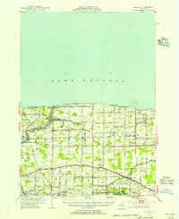 1949 Kendall1956 Print · USGSOrleans County at the close of the 1940s shows a landscape defined by the fruit belt of the lake plain and the historic transit lines of the south. Researchers can trace the path of the Erie Canal through Hindsburg or locate early rural schoolhouses like School No 6 and School No 12.
End of results
Showing maps 1-7 of 7
Top cities of Monroe County
- Rochester historical maps
- Greece historical maps
- Irondequoit historical maps
- Perinton historical maps
- Henrietta historical maps
- Webster historical maps
See more
Frequently asked questions
- What are the different types of historical maps available for Monroe County?
- What is the oldest map of Monroe County?
- Where can I purchase historical maps of Monroe County for my home or office?
- Where can I download high-res historical maps of Monroe County?
- Are there historical topographic maps available for Monroe County?
- Is there historical aerial imagery available for Monroe County?
- Where are historical maps of Monroe County sourced from?