1950s Maps of Wilson, New York
Explore 2 historic maps of Wilson from the 1950s. These maps offer a rare glimpse into what life looked like during the 1950s — showing old roads, neighborhoods, homes, and landmarks that have changed or disappeared over time.
Whether you're researching your family's past, planning a metal detecting trip, or studying how Wilson's landscape evolved across the 1950s, these high-resolution maps are a powerful tool for exploring the history of this region.
- Focus on a specific era: All maps on this page are from the 1950s, giving you a focused view of this time period.
- See what’s changed: Compare century-old streets, trails, and buildings to today's modern landscape using overlays and satellite layers.
- Research with precision: Use these maps for genealogy, historical research, land use analysis, or educational projects.
- View, download, or print: Maps are fully viewable online in high resolution, and can be downloaded or printed for your own records.
Start exploring Wilson's history through authentic maps from the 1950s. This is your window into the past.
Wilson, NY maps
(2)- 1950 Map of Ransomville
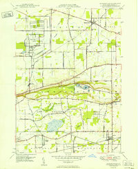 1950 Ransomville1950 Print · USGSMid-century Niagara County is captured here at a time when the Tuscarora Indian Reservation and the New York Central Railroad defined the local landscape. Genealogists can trace family footprints through numerous rural landmarks like St Michaels Cem, Model City, and School No 11.
 - 1952 Map of Toronto, 1954 Print
 1952 Toronto1954 Print · USGSLake Ontario and the international border define this mid-century landscape of rapid industrial and suburban growth. Researchers can trace the vital shipping and rail corridors of the era, from the Welland Canal to the New York Central Railroad.
End of results
Showing maps 1-2 of 2
Top cities near Wilson
- Amherst historical maps
- Niagara Falls historical maps
- Clarence historical maps
- North Tonawanda historical maps
- Grand Island historical maps
- Lockport historical maps
See more
Top neighborhoods of Wilson
- Coolidge Beach historical maps
- Sunset Beach historical maps
- East Wilson historical maps
- Elberta historical maps
- Roosevelt Beach historical maps
- South Wilson historical maps
See more
Frequently asked questions
- What are the different types of historical maps available for Wilson?
- What is the oldest map of Wilson?
- Where can I purchase historical maps of Wilson for my home or office?
- Where can I download high-res historical maps of Wilson?
- Are there historical topographic maps available for Wilson?
- Is there historical aerial imagery available for Wilson?
- Where are historical maps of Wilson sourced from?