1940s Maps of East Bloomfield, New York
Explore 3 historic maps of East Bloomfield from the 1940s. These maps offer a rare glimpse into what life looked like during the 1940s — showing old roads, neighborhoods, homes, and landmarks that have changed or disappeared over time.
Whether you're researching your family's past, planning a metal detecting trip, or studying how East Bloomfield's landscape evolved across the 1940s, these high-resolution maps are a powerful tool for exploring the history of this region.
- Focus on a specific era: All maps on this page are from the 1940s, giving you a focused view of this time period.
- See what’s changed: Compare century-old streets, trails, and buildings to today's modern landscape using overlays and satellite layers.
- Research with precision: Use these maps for genealogy, historical research, land use analysis, or educational projects.
- View, download, or print: Maps are fully viewable online in high resolution, and can be downloaded or printed for your own records.
Start exploring East Bloomfield's history through authentic maps from the 1940s. This is your window into the past.
East Bloomfield, NY maps
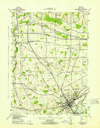
(3)- 1942 Map of Victor
 1942 Victor1942 Print · USGSOntario County during the early 1940s reveals a landscape defined by the convergence of the Lehigh Valley and New York Central railroads. You can trace early family settlements and rural centers like Ionia, East Bloomfield, and the historic burial grounds at French Cem or Dibble Cem.
 - 1942 Map of Canandaigua
 1942 Canandaigua1942 Print · USGSOntario County is captured here in the early 1940s, showing the transition from the city of Canandaigua to the surrounding farm townships. Researchers can locate many family-named landmarks and rural hubs, including Farmington Station, South Farmington Chapel, and Ackley Cem.
 - 1942 Map of Canandaigua Lake
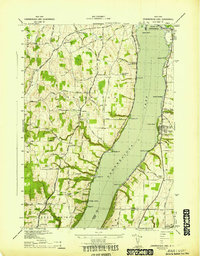 1942 Canandaigua Lake1942 Print · USGSCanandaigua Lake and its eastern and western shores are captured here during the early 1940s. Genealogists and local historians can trace the lakeside landings and rural family plots including Lucas Cem, Remington Cem, and the community at Cheshire.
End of results
Showing maps 1-3 of 3
Top cities near East Bloomfield
- Rochester historical maps
- Perinton historical maps
- Henrietta historical maps
- Penfield historical maps
- Brighton historical maps
- Pittsford historical maps
See more
Top neighborhoods of East Bloomfield
Frequently asked questions
- What are the different types of historical maps available for East Bloomfield?
- What is the oldest map of East Bloomfield?
- Where can I purchase historical maps of East Bloomfield for my home or office?
- Where can I download high-res historical maps of East Bloomfield?
- Are there historical topographic maps available for East Bloomfield?
- Is there historical aerial imagery available for East Bloomfield?
- Where are historical maps of East Bloomfield sourced from?