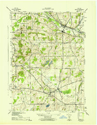
1942 Map of Victor
USGS Topo · Published 1942About this map
Victor sits at a critical rail junction in western New York, where the Lehigh Valley and New York Central lines converge amidst a landscape of glacial drumlins and fertile valleys. During the early 1940s, the area supported a robust agricultural and transport economy, connecting settlements like East Bloomfield, Holcomb, and Ionia through an intricate network of rural roads such as Cheese Factory Road and Mile Square Road. The topography is defined by prominent elevations like Boughton Hill and Fort Hill, which overlook the winding paths of Mud Creek and Sucker Brook. Local history is deeply etched into the land through numerous small burial grounds, including Boughton Hill Cem and Tomlinson Corners Cem. The map captures a transitional era of rural life, evidenced by the infrastructure at Wheeler Station and the strategic Fairport Reservoir.
Find a feature on this map
62 named features on this map. Tap any name to fly to it.
Don’t see what you’re looking for? This feature index may not catch every label — zoom into the map to look around manually.
Map Details
Editions of this 1942 Victor Map
This is the sole edition of this map. No revisions or reprints were ever made.
Other maps of this area

1895 · Rochester
USGS Topo · 1:62,500

1898 · Rochester
USGS Topo · 1:62,500

1900 · Macedon
USGS Topo · 1:62,500

1900 · Canandaigua
USGS Topo · 1:62,500

1901 · Honeoye
USGS Topo · 1:62,500

1903 · Canandaigua
USGS Topo · 1:62,500

1904 · Honeoye
USGS Topo · 1:62,500

1912 · Rochester
USGS Topo · 1:62,500

1920 · Rochester
USGS Topo · 1:62,500

1931 · Mendon Ponds
USGS Topo · 1:24,000