1990s Maps of Cornwall, New York
Explore 2 historic maps of Cornwall from the 1990s. These maps offer a rare glimpse into what life looked like during the 1990s — showing old roads, neighborhoods, homes, and landmarks that have changed or disappeared over time.
Whether you're researching your family's past, planning a metal detecting trip, or studying how Cornwall's landscape evolved across the 1990s, these high-resolution maps are a powerful tool for exploring the history of this region.
- Focus on a specific era: All maps on this page are from the 1990s, giving you a focused view of this time period.
- See what’s changed: Compare century-old streets, trails, and buildings to today's modern landscape using overlays and satellite layers.
- Research with precision: Use these maps for genealogy, historical research, land use analysis, or educational projects.
- View, download, or print: Maps are fully viewable online in high resolution, and can be downloaded or printed for your own records.
Start exploring Cornwall's history through authentic maps from the 1990s. This is your window into the past.
Cornwall, NY maps
(2)- 1994 Map of Popolopen Lake, 1999 Print
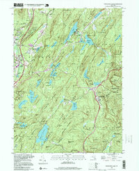 1994 Popolopen Lake1999 Print · USGSOrange and Rockland counties appear in the mid-1990s as a haven of state parks and West Point training grounds. Genealogists and hikers can trace old valley roads to the Quaker Meetinghouse, the Silver Mine, and the site of Doodletown.
 - 1994 Map of Cornwall-on-Hudson, 2000 Print
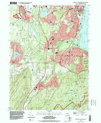 1994 Cornwall-on-Hudson2000 Print · USGSThe Hudson Highlands meet the river in the mid-1990s, where steep ridgelines overlook a landscape shaped by military history and regional infrastructure. Genealogists and historians can trace institutional sites like the N Y Mil Academy, Epiphany Apostolic College, and burial grounds at Calvary Cemetery.
End of results
Showing maps 1-2 of 2
Top cities near Cornwall
- Ramapo historical maps
- Clarkstown historical maps
- Poughkeepsie historical maps
- Cortlandt historical maps
- Ossining historical maps
- Haverstraw historical maps
See more
Top neighborhoods of Cornwall
- Meadowbrook historical maps
- West Cornwall historical maps
- Orrs Mill historical maps
- Mountainville historical maps
- Firthcliffe Heights historical maps
- Firthcliffe historical maps
See more
Frequently asked questions
- What are the different types of historical maps available for Cornwall?
- What is the oldest map of Cornwall?
- Where can I purchase historical maps of Cornwall for my home or office?
- Where can I download high-res historical maps of Cornwall?
- Are there historical topographic maps available for Cornwall?
- Is there historical aerial imagery available for Cornwall?
- Where are historical maps of Cornwall sourced from?