Old Maps of Newburgh, New York for Hiking & Exploration
Hike through history with 50 historic maps of Newburgh. Explore old trails, ghost towns, and forgotten backroads — perfect for outdoor adventurers and local explorers.
- Rediscover forgotten places: Map out old mining camps, roads, and footpaths that no longer exist on modern maps.
- Layer with modern tools: Combine with LiDAR or satellite views to plan hikes through historical terrain.
- Made for exploration: Popular among hikers, overlanders, and local history lovers.
Use these maps to find adventure and explore the hidden past of Newburgh.
Newburgh, NY maps
(50)- 1892 Map of West Point
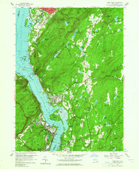
 1892 West Point1892 Print · USGSThe Hudson Highlands and river valley are captured here in the early 1890s, when iron mining and river-side rail travel defined the region. Trace ancestral roots and old landmarks from the military grounds at West Point to the iron operations at Mahopac Mine and the rail hub at Peekskill.
 - 1893 Map of Poughkeepsie
 1893 Poughkeepsie1893 Print · USGSDutchess and Ulster counties thrive during the late Victorian era as a hub of river commerce, rail junctions, and major state institutions. Researchers can trace the 1890s footprints of Vassar College, the busy Hampton Ferry, and the rail lines meeting at Hopewell Junction.
 - 1894 Map of West Point
 1894 West Point1894 Print · USGSThe Hudson Highlands in the late nineteenth century were a hub of river commerce and rail expansion. Genealogists and local historians can trace the footprint of the West Point military grounds, the industrial Mahopac Mines, and early settlements like Yorktown Heights.3 unique versions available
 - 1894 Map of Poughkeepsie
 1894 Poughkeepsie1894 Print · USGSThe Hudson Valley in the early 1890s was a bustling corridor of rail and river commerce connecting POUGHKEEPSIE to the industrial south. Genealogists and historians can trace old homesteads near Vassar College, find early river landings like Carthage Landing, or locate the junction at Hopewell Junction.3 unique versions available
 - 1899 Map of West Point
 1899 West Point1899 Print · USGSThe Hudson Highlands and military grounds at West Point are detailed in this survey from the closing years of the nineteenth century. Genealogists can trace old family-named sites like Mc Keel Corners or Travis Corners, while historians can locate the Mahopac Mines and the Albany Post Road.
 - 1901 Map of West Point
 1901 West Point1901 Print · USGSThe Hudson Highlands and West Point are shown at the turn of the century, when river railroads and mountain mines defined the local economy. Genealogists can trace family landmarks and hamlets like Nelsonville, Mahopac Mines, and Yorktown Heights.12 unique versions available
 - 1902 Map of Schunemunk
 1902 Schunemunk1902 Print · USGSOrange County at the turn of the century shows a landscape defined by the rise of the railroad and the enduring presence of the Highlands. Genealogists and historians can trace old homesteads and industrial sites like Bull Mine, Oxford Depot, and the riverfront at Cornwall Landing.10 unique versions available
 - 1903 Map of Poughkeepsie
 1903 Poughkeepsie1903 Print · USGSDutchess and Ulster Counties thrive at the turn of the century as a major corridor of river commerce and rail expansion. Genealogists and historians can trace institutional history at the Hudson River State Hospital or locate lost rail stops at Clove Branch Junction and Diddell.11 unique versions available
 - 1903 Map of Newburg
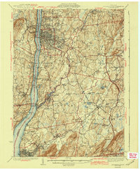
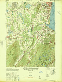
 1903 Newburg1903 Print · USGSThe Hudson Valley was entering a period of rapid industrial and rail expansion when this survey was conducted. Researchers can trace the path of the New England RR, find local landmarks like the Powder Works, and locate old hamlets such as Ganahgote and Leptondale.10 unique versions available
 - 1930 Map of Schunemunk
 1930 Schunemunk1930 Print · USGSOrange County's rail and river landscapes come into sharp focus during the late Prohibition era. Researchers can trace historic district schoolhouses like Elmwood No. 6 School and the critical junction points of the ERIE RR near Vails Gate Junction.3 unique versions available
 - 1935 Map of Schunemunk
 1935 Schunemunk1935 Print · USGSOrange County in the mid-1930s is a crossroads of heavy rail and Hudson River commerce. Genealogists and historians can trace defunct rail sidings, old school sites like Quaker Hill Sch, and industrial landmarks from Bull Mine to Firthcliffe.4 unique versions available
 - 1936 Map of West Point
 1936 West Point1936 Print · USGSThe Hudson Highlands in the mid-1930s reveal a landscape of strategic military grounds and evolving state parks. Genealogists and historians can trace old family burial grounds like Halstead Cem, the workings of the Mahopac Mines, and the early layout of West Point.2 unique versions available
 - 1936 Map of Poughkeepsie
 1936 Poughkeepsie1936 Print · USGSDutchess County in the mid-thirties reveals a landscape of massive riverside institutions and early aviation fields along the Hudson River. Local historians can trace family roots through numerous country schools like Fairview Sch or locate the old Poughkeepsie Landing (Air Field).
 - 1941 Map of West Point
 1941 West Point1941 Print · USGSThe Hudson Highlands were undergoing significant change in the years leading up to the war, blending heavy industry with expanding military installations. Genealogists can trace family lines through Continental Village, Hillside Cem, and the various schools like Manitou Sch.3 unique versions available
 - 1941 Map of West Point, 1951 Print
 1941 West Point1951 Print · USGSThe Hudson Highlands are captured here in the mid-1950s as the river-and-rail economy defined life in Beacon and Cold Spring. Researchers can trace the grounds of the U S Military Academy West Point, locating the U S Silver Depository and Constitution Island.
 - 1942 Map of Walden, 1958 Print
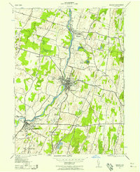 1942 Walden1958 Print · USGSOrange County's Wallkill Valley at the height of the war era reveals a landscape of riverside industry and family-owned dairy farms. Genealogists and local historians can trace legacy sites like the Borden Estate, Montgomery Worsted Mills, and Goodwill Church.
 - 1943 Map of Poughkeepsie
 1943 Poughkeepsie1943 Print · USGSThe mid-Hudson valley is captured here in the years during the Second World War, showing the busy corridor between Poughkeepsie and Beacon. Researchers can trace old institutional lands like Vassar College or locate vanished rural schools such as Swede Sch and Devine Sch.3 unique versions available
 - 1943 Map of Walden
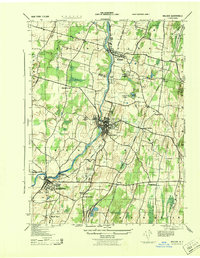 1943 Walden1943 Print · USGSOrange County's riverfront villages and dairy heritage are captured here in the early 1940s. Genealogists can locate family landmarks like the Borden Estate or St Marys Cemetery, while tracing the paths of the Wallkill Valley Branch railroad.
 - 1946 Map of Newburgh, 1964 Print
 1946 Newburgh1964 Print · USGSMid-Hudson Valley life in the mid-forties is captured here, showing the region as it transitioned from a rural agricultural economy to a postwar industrial hub. Genealogists and local historians can locate dozens of small schools and cemeteries, from the New Paltz Cemetery to the Montgomery Worsted Mills.
 - 1947 Map of West Point
 1947 West Point1947 Print · USGSPost-war Orange and Putnam Counties appear here during a period of steady highland growth along the river. Trace the old village footprints of Cold Spring and Garrison, or locate family landmarks like Mekeel Corners and St Marys Ch.
 - 1947 Map of West Point
 1947 West Point1947 Print · USGSThe Hudson Highlands and the Peekskill waterfront are captured just before the post-war boom, showing the critical junction of river, rail, and early parkways. Genealogists can trace family landmarks and burial sites like Cold Spring Cem, Amawalk Cem, and the historic Mahopac Mines.
 - 1947 Map of Cornwall
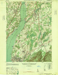
 1947 Cornwall1947 Print · USGSOrange County near the Hudson River is shown here just after the war, featuring the major expansion of Stewart AAF and local rail activity. Trace the routes of the Erie Railroad through industrial Salisbury Mills or locate the rural Mt Airy School.2 unique versions available
 - 1947 Map of Wappinger Falls
 1947 Wappinger Falls1947 Print · USGSThe Hudson River corridor in the late 1940s is shown here at its post-war industrial height, from the busy streets of Beacon to the mills of Wappingers Falls. Researchers can trace the legacy of major institutions like Matteawan State Hospital or locate local landmarks such as Danskammer Light and Cedar Cliff School.2 unique versions available
 - 1947 Map of Newburgh North
 1947 Newburgh North1947 Print · USGSMid-century Orange County comes alive along the western Hudson at a time when river transport and rural schoolhouses defined the landscape. Genealogists can trace family names through the Plattekill School and Savilton, or locate landmarks like Pine Point Casino.
 - 1947 Map of Hartford, 1955 Print
 1947 Hartford1955 Print · USGSSouthern New England and the Hudson Valley are shown in detail during the post-war expansion era. Genealogists and researchers can trace local landmarks from the State Capitol and Yale University to the Stratford Lighthouse and Woodlawn Cem.2 unique versions available
Showing maps 1-25 of 50
Top cities near Newburgh
- Poughkeepsie historical maps
- Cortlandt historical maps
- Yorktown historical maps
- Kiryas Joel historical maps
- Palm Tree historical maps
- Warwick historical maps
See more
Top neighborhoods of Newburgh
- Cedar Cliff historical maps
- Roseton historical maps
- Middle Hope historical maps
- Fostertown historical maps
- Cronomer Valley historical maps
- Glenwood Park historical maps
See more
Frequently asked questions
- What are the different types of historical maps available for Newburgh?
- What is the oldest map of Newburgh?
- Where can I purchase historical maps of Newburgh for my home or office?
- Where can I download high-res historical maps of Newburgh?
- Are there historical topographic maps available for Newburgh?
- Is there historical aerial imagery available for Newburgh?
- Where are historical maps of Newburgh sourced from?