2020s Maps of Warwick, New York
Explore 7 historic maps of Warwick from the 2020s. These maps offer a rare glimpse into what life looked like during the 2020s — showing old roads, neighborhoods, homes, and landmarks that have changed or disappeared over time.
Whether you're researching your family's past, planning a metal detecting trip, or studying how Warwick's landscape evolved across the 2020s, these high-resolution maps are a powerful tool for exploring the history of this region.
- Focus on a specific era: All maps on this page are from the 2020s, giving you a focused view of this time period.
- See what’s changed: Compare century-old streets, trails, and buildings to today's modern landscape using overlays and satellite layers.
- Research with precision: Use these maps for genealogy, historical research, land use analysis, or educational projects.
- View, download, or print: Maps are fully viewable online in high resolution, and can be downloaded or printed for your own records.
Start exploring Warwick's history through authentic maps from the 2020s. This is your window into the past.
Warwick, NY maps
(7)- 2023 Map of Warwick, 2023 Print
 2023 Warwick2023 Print · USGSOrange County's mix of historic villages and ridge-line trails is clearly visible in this recent survey. Local researchers can locate family sites like Wisner Cem or trace the Appalachian National Scenic Trail as it crosses Bellvale Mountain.
 - 2023 Map of Monroe, 2023 Print
 2023 Monroe2023 Print · USGSOrange County's ridgelines and glacial lakes come into focus in this recent survey of the Monroe area. Researchers can trace land use from the Bull Mine area to local history sites like Seamanville Cem and the Uta Mesivta of Kiryas Joel.
 - 2023 Map of Unionville, 2023 Print
 2023 Unionville2023 Print · USGSThe borderlands of Orange County and Sussex County are shown in detail here during the early 2020s. Genealogists and local historians can trace family locations near Minisink Cem, the old crossroads of Waterloo Mills, and the banks of Rutgers Creek.
 - 2023 Map of Pine Island, 2023 Print
 2023 Pine Island2023 Print · USGSThe black dirt agricultural region of Orange County and Sussex County is shown here in the 2020s, featuring the iconic Wallkill Valley drainage network. Genealogists can locate several local burial sites such as Saint Stanislaus Cem and Stewartstown Cem near settlements like Pine Island and Edenville.
 - 2023 Map of Wawayanda, 2023 Print
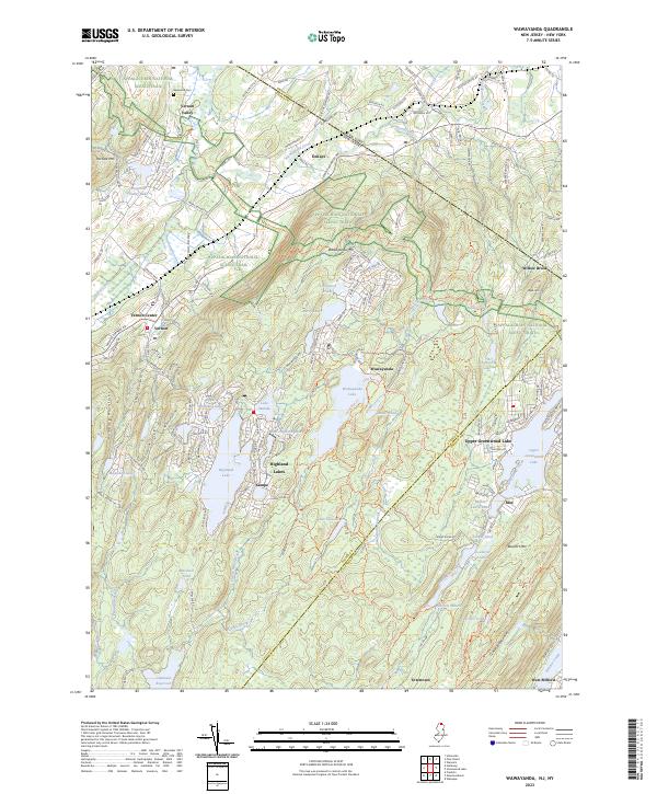 2023 Wawayanda2023 Print · USGSThe Highlands of Sussex and Passaic counties are documented here in the early twenty-first century, showing a landscape defined by ridgeline trails and mountain lakes. Researchers can locate community landmarks like Glenwood Cem or trace the Appalachian National Scenic Trail past Wawayanda and Highland Lakes.
 - 2023 Map of Greenwood Lake, 2023 Print
 2023 Greenwood Lake2023 Print · USGSCrossing the state line between New York and New Jersey, this recent survey captures the high-country settlements and conservation lands surrounding Greenwood Lake. Genealogists and hikers can trace the Appalachian National Scenic Trail, the Erskine Grave Site, and the historic Ringwood Mill Pond.
 - 2023 Map of Sloatsburg, 2023 Print
 2023 Sloatsburg2023 Print · USGSThe Ramapo River valley and the highlands of Rockland County come into focus during this modern era of development. Trace family-named landmarks and local history through Sloatsburg, the winding roads of Tuxedo Park, and the historic Saint Elizabeth Memorial Chapel.
End of results
Showing maps 1-7 of 7
Top cities near Warwick
- Ramapo historical maps
- Kiryas Joel historical maps
- Palm Tree historical maps
- Wallkill historical maps
- Middletown historical maps
- West Milford historical maps
See more
Top neighborhoods of Warwick
- New Milford historical maps
- Dutch Hollow historical maps
- Lakeville historical maps
- Pine Island historical maps
- Edenville historical maps
- Little York historical maps
See more
Frequently asked questions
- What are the different types of historical maps available for Warwick?
- What is the oldest map of Warwick?
- Where can I purchase historical maps of Warwick for my home or office?
- Where can I download high-res historical maps of Warwick?
- Are there historical topographic maps available for Warwick?
- Is there historical aerial imagery available for Warwick?
- Where are historical maps of Warwick sourced from?