Old Maps of Constantia, New York for Genealogy
Trace your family roots with 65 historic maps of Constantia. These high-res maps reveal old neighborhoods, homesites, landmarks, and streets — helping you uncover where your ancestors lived and how the area evolved over time.
- Explore historic neighborhoods: Identify where your relatives may have lived in the 1800s or 1900s.
- Compare maps over time: Trace the changes in streets, buildings, and landmarks for multi-generational research.
- Perfect for genealogy & ancestry research: Used by family historians and researchers to map out lineage and migration.
These maps are an incredible resource for exploring your personal connection to Constantia's past.
Constantia, NY maps
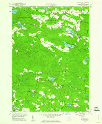
(65)- 1895 Map of Chittenango
 1895 Chittenango1895 Print · USGSMadison County and the southern shores of Oneida Lake are shown here at the height of the canal and rail era. Researchers can trace the path of the Erie Canal through Chittenango and Canastota or locate vanished sites like Fyler Settlement.
 - 1895 Map of Syracuse
 1895 Syracuse1895 Print · USGSSyracuse and the surrounding canal country are captured here in the late nineteenth century as the region thrived on salt production and rail traffic. Trace the vanished industrial Salt Sheds, the historic Erie Canal, and landmarks like the State Fair Grounds.
 - 1898 Map of Syracuse
 1898 Syracuse1898 Print · USGSSyracuse was a burgeoning railroad and canal junction at the end of the nineteenth century, surrounded by thriving villages and salt works. Genealogists and historians can trace family-named sites and vanished industrial works near the Salt Sheds, Cicero Swamp, and Fayetteville.10 unique versions available
 - 1898 Map of Chittenango
 1898 Chittenango1898 Print · USGSThe northern shore of Oneida Lake and the bustling Erie Canal corridor are captured here during the peak of New York's rail expansion. Researchers can trace the original canal path through Chittenango or locate vanished stops along the West Shore R. R. and Elmira and Cortland Br.
 - 1902 Map of Chittenango
 1902 Chittenango1902 Print · USGSMadison and Onondaga Counties are shown at a peak of rail and canal activity in the early 1900s. Genealogists and historians can trace the path of the Erie Canal through Canastota or locate smaller locales like Fyler Settlement and Quality Hill.7 unique versions available
 - 1905 Map of Mexico
 1905 Mexico1905 Print · USGSOswego County at the turn of the century shows a landscape of busy crossroads and emerging rail junctions. Genealogists can trace family footprints through numerous named settlements like Colosse, Howardville, and Union Settlement or locate old industrial sites like Carleys Mills.6 unique versions available
 - 1906 Map of Kasoag
 1906 Kasoag1906 Print · USGSOswego and Oneida counties are shown here in the early twentieth century as a thriving network of rail-linked hamlets and remote farmsteads. Researchers can trace old family locations near Florence Hill, North Amboy, and the State Fish Hatchery.7 unique versions available
 - 1940 Map of Cicero, 1957 Print
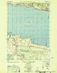
 1940 Cicero1957 Print · USGSOneida Lake’s southern shoreline was still largely rural and agricultural in the years before the war. Genealogists and local historians can trace family-named landmarks and early district schools like Van Anthrup Sch and the Cobblestone Sch.
 - 1941 Map of Cleveland
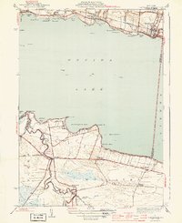
 1941 Cleveland1941 Print · USGSOneida Lake’s central waters and the surrounding shorelines are captured here in the early 1940s, highlighting a landscape of rail-connected villages and rural school districts. Genealogists can locate family landmarks like Smith Ridge Cem or trace the path of the New York Ontario and Western RR through Bernhard Bay.2 unique versions available
 - 1941 Map of Jewell
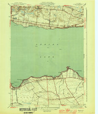
 1941 Jewell1941 Print · USGSOneida Lake shoreline communities in the early 1940s are documented here, showing a mix of established lakeside hamlets and inland farming hubs. Genealogists and local historians can locate early landmarks like Lakeport Chapel, West Church, and the rural Whitelaw Cem.
 - 1943 Map of Camden West
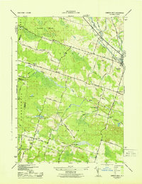 1943 Camden West1943 Print · USGSThe rural landscapes of Oneida and Oswego counties are captured here in the mid-1940s, showing a world of small schoolhouses and family-named crossroads. Researchers can trace historic cemeteries like Pete Lynch Cem or locate vanished landmarks near Brockway Corners and Maple Flats.2 unique versions available
 - 1943 Map of Mallory
 1943 Mallory1943 Print · USGSOswego County in the early 1940s shows a landscape of rail-dependent hamlets and numbered school districts north of Oneida Lake. Genealogists can locate family names at Little France, Mud Settlement, and the Ingersoll Cem near the railroad.
 - 1943 Map of Panther Lake
 1943 Panther Lake1943 Print · USGSOswego County's wooded lake country is shown in detail during the early 1940s, featuring a landscape of small hamlets and numerous rural schoolhouses. Genealogists can trace family landmarks and local centers like Amboy Center, Dutcherville, and the Hall Cem.
 - 1944 Map of Cleveland
 1944 Cleveland1944 Print · USGSOneida Lake's northern and southern shores are captured here during the mid-1940s, showing a landscape defined by the railroad and the canal. Genealogists can trace family roots through school locations like Bushnell Sch and early road networks including Bull Street and Lagrange Road.2 unique versions available
 - 1944 Map of Cicero
 1944 Cicero1944 Print · USGSOnondaga County in the early 1940s shows a landscape of lakeside retreats and rural schoolhouses along the southern shore of Oneida Lake. Genealogists can trace family footprints at Cicero Center Cem and locate vanished local landmarks like Stone Arabia Sch and Toad Harbor.2 unique versions available
 - 1944 Map of Jewell
 1944 Jewell1944 Print · USGSOneida Lake and its surrounding hamlets are captured here during the mid-forties, highlighting the vital lakefront economies of both the north and south shores. Genealogists and local historians can trace family locations near Jewell, Lakeport, or the Whitelaw Cem.2 unique versions available
 - 1950 Map of Utica, 1951 Print
 1950 Utica1951 Print · USGSCentral New York in the post-war era showcases the industrial Mohawk Valley and the pristine Adirondack interior. Researchers can trace transportation networks like the New York Central Railroad and find early Cold War sites such as Griffiss Air Force Base.
 - 1951 Map of Cleveland
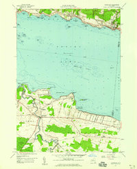
 1951 Cleveland1951 Print · USGSOneida Lake and its northern shoreline villages are captured here in the early fifties, showing the region's transition into a modern transportation hub. Genealogists and local historians can trace the foundations of Cleveland, Bridgeport, and Constantia, alongside landmarks like Dakin Bay Sch and the Barge Canal Route.
 - 1957 Map of Utica
 1957 Utica1957 Print · USGSCentral New York and the Adirondack foothills are captured here in the mid-fifties, showing a landscape defined by the Mohawk River corridor and the growing highway system. Genealogists and researchers can trace the rail lines of the New York Central and locate communities from Lowville to Gloversville.
 - 1957 Map of Cleveland, 1959 Print
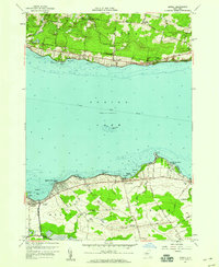
 1957 Cleveland1959 Print · USGSOneida Lake’s southern and northern shores are captured in the late 1950s, showing the established communities of Cleveland and Bridgeport. Genealogists can trace family footprints near St Marys Ch, Bridgeport Central Sch, and the Cornell Univ Biological Field Sta.2 unique versions available
 - 1957 Map of Mallory, 1959 Print
 1957 Mallory1959 Print · USGSThe northern shores of Oneida Lake appear in the late fifties as a landscape of sprawling wetlands and quiet agricultural crossroads. Researchers can find old family landmarks and civic centers like Little France Ch, Mud Settlement, and the Carleys Mills Cem.3 unique versions available
 - 1957 Map of Cicero, 1959 Print
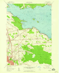 1957 Cicero1959 Print · USGSNorthern Onondaga County enters a period of rapid suburban growth in the late fifties as residential streets expand toward the lake. Researchers can trace family sites from North Syracuse to the rural Cicero Center, including the Cicero Center Cem and Thompson Rd Ch.2 unique versions available
 - 1957 Map of Jewell, 1959 Print
 1957 Jewell1959 Print · USGSOneida Lake was a center of lakeside recreation and rural life in the late fifties, spanning the shores of Madison and Oneida counties. Researchers can find lakeside landmarks like the seaplane base at Lakeport or trace family roots near Whitelaw Cemetery and Gees Corner.3 unique versions available
 - 1959 Map of Panther Lake, 1960 Print
 1959 Panther Lake1960 Print · USGSOswego County is shown in transition during the late fifties, where reforestation efforts and timberlands met a scattering of small lakeside hamlets. Researchers can trace family history through Hall Cem and old crossroads like Dutcherville or Jamison Corners.3 unique versions available
 - 1960 Map of Rochester
 1960 Rochester1960 Print · USGSThe Lake Ontario shoreline in the late fifties was a bustling corridor of rail and water commerce. Genealogists and historians can trace the path of the New York Central through canal towns like Newark or explore the coastal landmarks around Sackets Harbor.2 unique versions available
Showing maps 1-25 of 65
Top cities near Constantia
- Syracuse historical maps
- Clay historical maps
- Manlius historical maps
- Salina historical maps
- Cicero historical maps
- De Witt historical maps
See more
Top neighborhoods of Constantia
- Gayville historical maps
- Dutcherville historical maps
- North Constantia historical maps
- Panther Lake historical maps
- Bernhards Bay historical maps
- Nicholsville historical maps
See more
Frequently asked questions
- What are the different types of historical maps available for Constantia?
- What is the oldest map of Constantia?
- Where can I purchase historical maps of Constantia for my home or office?
- Where can I download high-res historical maps of Constantia?
- Are there historical topographic maps available for Constantia?
- Is there historical aerial imagery available for Constantia?
- Where are historical maps of Constantia sourced from?