1950s Maps of Patterson, New York
Explore 2 historic maps of Patterson from the 1950s. These maps offer a rare glimpse into what life looked like during the 1950s — showing old roads, neighborhoods, homes, and landmarks that have changed or disappeared over time.
Whether you're researching your family's past, planning a metal detecting trip, or studying how Patterson's landscape evolved across the 1950s, these high-resolution maps are a powerful tool for exploring the history of this region.
- Focus on a specific era: All maps on this page are from the 1950s, giving you a focused view of this time period.
- See what’s changed: Compare century-old streets, trails, and buildings to today's modern landscape using overlays and satellite layers.
- Research with precision: Use these maps for genealogy, historical research, land use analysis, or educational projects.
- View, download, or print: Maps are fully viewable online in high resolution, and can be downloaded or printed for your own records.
Start exploring Patterson's history through authentic maps from the 1950s. This is your window into the past.
Patterson, NY maps
(2)- 1958 Map of Pawling, 1960 Print
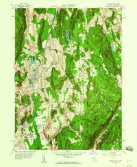 1958 Pawling1960 Print · USGSDutchess County and eastern Connecticut are mapped here in the late fifties, showing the region as the Harlem Valley railroad corridor remained central to local life. Genealogists can trace family landmarks and schools like Trinity-Pawling Sch, the Meeting House on Quaker Hill, and old junctions at Hurd Corners.4 unique versions available
 - 1958 Map of Brewster, 1960 Print
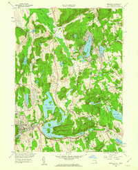 1958 Brewster1960 Print · USGSThe New York and Connecticut borderlands come alive in the late fifties as rail lines and new highways intersect among the Croton reservoirs. Genealogists and historians can trace old community ties in Sodom, Milltown, and the lakeside homes around Putnam Lake.5 unique versions available
End of results
Showing maps 1-2 of 2
Top cities near Patterson
- Danbury historical maps
- Yorktown historical maps
- Carmel historical maps
- East Fishkill historical maps
- Wappinger historical maps
- Ridgebury historical maps
See more
Top neighborhoods of Patterson
- Putnam Lake historical maps
- West Patterson historical maps
- Haines Corners historical maps
- Field Corners historical maps
- Steinbeck Corners historical maps
- Towners historical maps
Frequently asked questions
- What are the different types of historical maps available for Patterson?
- What is the oldest map of Patterson?
- Where can I purchase historical maps of Patterson for my home or office?
- Where can I download high-res historical maps of Patterson?
- Are there historical topographic maps available for Patterson?
- Is there historical aerial imagery available for Patterson?
- Where are historical maps of Patterson sourced from?