1990s Maps of Cranberry Lake, Clifton
Explore 2 historic maps of Cranberry Lake from the 1990s. These maps offer a rare glimpse into what life looked like during the 1990s — showing old roads, neighborhoods, homes, and landmarks that have changed or disappeared over time.
Whether you're researching your family's past, planning a metal detecting trip, or studying how Cranberry Lake's landscape evolved across the 1990s, these high-resolution maps are a powerful tool for exploring the history of this region.
- Focus on a specific era: All maps on this page are from the 1990s, giving you a focused view of this time period.
- See what’s changed: Compare century-old streets, trails, and buildings to today's modern landscape using overlays and satellite layers.
- Research with precision: Use these maps for genealogy, historical research, land use analysis, or educational projects.
- View, download, or print: Maps are fully viewable online in high resolution, and can be downloaded or printed for your own records.
Start exploring Cranberry Lake's history through authentic maps from the 1990s. This is your window into the past.
Cranberry Lake, Clifton maps
(2)- 1999 Map of Newton Falls, 2001 Print
 1999 Newton Falls2001 Print · USGSThe St. Lawrence County highlands near the turn of the millennium reveal a landscape shaped by both Adirondack wilderness and industrial extraction. Local historians can trace the development of Newton Falls and Wanakena, locating the State Ranger Sch, mining operations, and the remote Cook Corners settlement.
 - 1999 Map of Cranberry Lake, 2001 Print
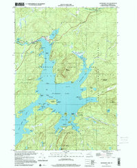 1999 Cranberry Lake2001 Print · USGSAdirondack wilderness and the complex shores of Cranberry Lake are captured here at the end of the millennium. Trace lakefront geography and research outposts like Joe Indian Island and the Cranberry Lake Biological Station.
End of results
Showing maps 1-2 of 2
Top cities near Cranberry Lake
- Oswegatchie historical maps
- Russell historical maps
- Webb historical maps
- Colton historical maps
- Fine historical maps
- Hopkinton historical maps
See more
Frequently asked questions
- What are the different types of historical maps available for Cranberry Lake?
- What is the oldest map of Cranberry Lake?
- Where can I purchase historical maps of Cranberry Lake for my home or office?
- Where can I download high-res historical maps of Cranberry Lake?
- Are there historical topographic maps available for Cranberry Lake?
- Is there historical aerial imagery available for Cranberry Lake?
- Where are historical maps of Cranberry Lake sourced from?