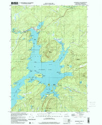
1999 Map of Cranberry Lake
USGS Topo · Published 2001About this map
Adirondack State Park encompasses this densely forested and aquatic landscape, dominated by the intricate shoreline of Cranberry Lake. The map reveals a wild interior at the turn of the 21st century, where the sprawling lake is dotted with named landforms like Joe Indian Island and Big Bog Island. Near the northern outlet where the Oswegatchie River begins, the small settlement of Cranberry Lake serves as a gateway to the surrounding preserves, including the Cliffton State Forest Preserve.
Find a feature on this map
82 named features on this map. Tap any name to fly to it.
Don’t see what you’re looking for? This feature index may not catch every label — zoom into the map to look around manually.
Map Details
Editions of this 1999 Cranberry Lake Map
This is the sole edition of this map. No revisions or reprints were ever made.
Other maps of this area

1907 · Tupper Lake
USGS Topo · 1:62,500

1919 · Cranberry Lake
USGS Topo · 1:62,500

1920 · Childwold
USGS Topo · 1:62,500

1921 · Cranberry Lake
USGS Topo · 1:62,500

1921 · Childwold
USGS Topo · 1:48,000

1921 · Stark
USGS Topo · 1:62,500

1922 · Childwold
USGS Topo · 1:62,500

1923 · Stark
USGS Topo · 1:62,500

1931 · Cranberry Lake
USGS Topo · 1:62,500

1940 · Stark
USGS Topo · 1:62,500