1910s Maps of Fine, New York
Explore 7 historic maps of Fine from the 1910s. These maps offer a rare glimpse into what life looked like during the 1910s — showing old roads, neighborhoods, homes, and landmarks that have changed or disappeared over time.
Whether you're researching your family's past, planning a metal detecting trip, or studying how Fine's landscape evolved across the 1910s, these high-resolution maps are a powerful tool for exploring the history of this region.
- Focus on a specific era: All maps on this page are from the 1910s, giving you a focused view of this time period.
- See what’s changed: Compare century-old streets, trails, and buildings to today's modern landscape using overlays and satellite layers.
- Research with precision: Use these maps for genealogy, historical research, land use analysis, or educational projects.
- View, download, or print: Maps are fully viewable online in high resolution, and can be downloaded or printed for your own records.
Start exploring Fine's history through authentic maps from the 1910s. This is your window into the past.
Fine, NY maps
(7)- 1913 Map of Lake Bonaparte, 1956 Print
 1913 Lake Bonaparte1956 Print · USGSThe Lewis and Jefferson County borderlands come to life in this pre-World War I survey of the Lake Bonaparte region. Researchers can trace the old New York Central rail line past historic landmarks like Kimball Mill and the French Settlement School.
 - 1915 Map of Russell, 1958 Print
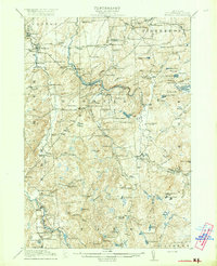
 1915 Russell1958 Print · USGSSt. Lawrence County was a landscape of remote school districts and family-named crossroads when this survey was conducted during the First World War. Local historians can trace the foundations of the regional iron industry at the Clifton Furnace Ruins or locate vanished rural centers like Pond Settlement and Whippoorwill Corners.
 - 1916 Map of Lake Bonaparte
 1916 Lake Bonaparte1916 Print · USGSUpper New York State at the dawn of the twentieth century shows a landscape defined by isolated settlements and a budding rail network. Researchers can trace the legacy of early families and industry through sites like Kimball Mill, Natural Bridge, and the French Settlement School.5 unique versions available
 - 1916 Map of Oswegatchie
 1916 Oswegatchie1916 Print · USGSSt. Lawrence County industry and wilderness meet in the early twentieth century along the Oswegatchie River. Genealogists and historians can trace rail-tied settlements at Benson Mines, remote schools like White School, and numerous named lumber and sporting camps.3 unique versions available
 - 1918 Map of Russell
 1918 Russell1918 Print · USGSSt. Lawrence County during the First World War era reveals a landscape of isolated farmsteads and rural school districts connected by winding rivers. Researchers can locate long-forgotten sites like the Clifton Furnace Ruins, the Scotland School, and the remote Pond Settlement.5 unique versions available
 - 1918 Map of Oswegatchie
 1918 Oswegatchie1918 Print · USGSThe Adirondack wilderness in the 1910s reveals a hardworking landscape of iron mines and timber camps. Genealogists and historians can trace family roots at Benson Mines, locate remote schoolhouses like White School, and follow the path of the Lumber R. R.5 unique versions available
 - 1919 Map of Cranberry Lake, 1959 Print
 1919 Cranberry Lake1959 Print · USGSThe northern Adirondack wilderness is captured here just after the Great War, showing a landscape defined by timber, mining, and the winding Oswegatchie River. Trace the early development of Benson Mines, the State Ranger School, and the remote landing at Wanakena.3 unique versions available
End of results
Showing maps 1-7 of 7
Top cities near Fine
- Oswegatchie historical maps
- Croghan historical maps
- De Kalb historical maps
- Russell historical maps
- Watson historical maps
- Webb historical maps
See more
Top neighborhoods of Fine
- Aldrich historical maps
- Coffins Mills historical maps
- Lower Oswegatchie historical maps
- Wanakena historical maps
- Briggs historical maps
- Oswegatchie historical maps
Frequently asked questions
- What are the different types of historical maps available for Fine?
- What is the oldest map of Fine?
- Where can I purchase historical maps of Fine for my home or office?
- Where can I download high-res historical maps of Fine?
- Are there historical topographic maps available for Fine?
- Is there historical aerial imagery available for Fine?
- Where are historical maps of Fine sourced from?