1960s Maps of Fine, New York
Explore 9 historic maps of Fine from the 1960s. These maps offer a rare glimpse into what life looked like during the 1960s — showing old roads, neighborhoods, homes, and landmarks that have changed or disappeared over time.
Whether you're researching your family's past, planning a metal detecting trip, or studying how Fine's landscape evolved across the 1960s, these high-resolution maps are a powerful tool for exploring the history of this region.
- Focus on a specific era: All maps on this page are from the 1960s, giving you a focused view of this time period.
- See what’s changed: Compare century-old streets, trails, and buildings to today's modern landscape using overlays and satellite layers.
- Research with precision: Use these maps for genealogy, historical research, land use analysis, or educational projects.
- View, download, or print: Maps are fully viewable online in high resolution, and can be downloaded or printed for your own records.
Start exploring Fine's history through authentic maps from the 1960s. This is your window into the past.
Fine, NY maps
(9)- 1961 Map of Ogdensburg
 1961 Ogdensburg1961 Print · USGSThe St. Lawrence valley and the Adirondack high country meet in this early sixties survey during a peak era for rail and river commerce. Genealogists and historians can trace the paths of the New York Central railroad through remote settlements like Wanakena, Conifer, and Piercefield.
 - 1966 Map of Oswegatchie SE, 1971 Print
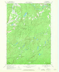
 1966 Oswegatchie SE1971 Print · USGSSt. Lawrence and Herkimer Counties are captured in the mid-sixties, showing a wild landscape of the Adirondack interior. Researchers and outdoorsmen can trace the paths of the Post Trail or locate remote water bodies like Emerald Lake and Streeter Lake.2 unique versions available
 - 1966 Map of Oswegatchie, 1971 Print
 1966 Oswegatchie1971 Print · USGSSt. Lawrence County is captured here in the mid-1960s, showing a landscape defined by the Penn Central railroad and the Oswegatchie River. Researchers can locate industrial sites like Benson Mines and Flat Rock Powerplant alongside local landmarks like Woodland Cem.3 unique versions available
 - 1966 Map of Oswegatchie SW, 1971 Print
 1966 Oswegatchie SW1971 Print · USGSAdirondack wilderness near the junction of three counties was still largely roadless in the mid-sixties. Outdoor historians and researchers can trace remote water routes and landmarks like Bryants Bridge, Trout Lake, and the Lookout Tower on Bald Mtn.
 - 1966 Map of Fine, 1971 Print
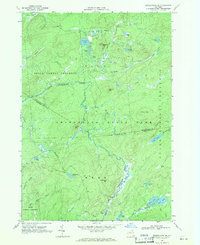
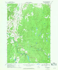
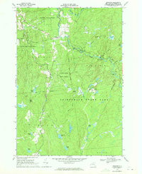
 1966 Fine1971 Print · USGSThe western Adirondack wilderness is captured here in the mid-sixties as remote settlements and state forests defined the landscape. Genealogists and historians can trace the Penn Central rail line through Jayville and Kalurah, or locate Camp Trefoil and Camp Portaferry.3 unique versions available
 - 1968 Map of Newton Falls, 1971 Print
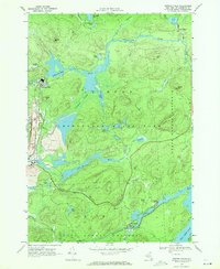 1968 Newton Falls1971 Print · USGSNewton Falls and Wanakena are pictured here in the late sixties, a period when Adirondack industrial mining operated alongside protected forest reserves. Researchers can trace the Penn Central rail line, find the local Cem, and locate the Strip Mine and Cook Corners settlement.2 unique versions available
 - 1969 Map of South Edwards, 1971 Print
 1969 South Edwards1971 Print · USGSSt. Lawrence County in the late sixties shows a landscape of river-driven industry and growing state forests. Researchers can trace the Oswegatchie River through South Edwards, locate the Powerplant, and find sites like Pond Settlement.2 unique versions available
 - 1969 Map of Degrasse, 1971 Print
 1969 Degrasse1971 Print · USGSThe northern Adirondacks in the late sixties reveal a landscape of active forestry and industrial memory. Trace the convergence of the South Branch Grass River and explore the historic Clifton Furnace Ruins and Pleasant View Cem.3 unique versions available
 - 1969 Map of Five Ponds, 1972 Print
 1969 Five Ponds1972 Print · USGSSt. Lawrence County is seen here in the late sixties as a sprawling wilderness within the Adirondacks before modern trail expansions. Researchers can locate remote landmarks like Janacks Landing, Griffin Rapids, and the clusters of Big Five Ponds.2 unique versions available
End of results
Showing maps 1-9 of 9
Top cities near Fine
- Oswegatchie historical maps
- Croghan historical maps
- De Kalb historical maps
- Russell historical maps
- Watson historical maps
- Webb historical maps
See more
Top neighborhoods of Fine
- Aldrich historical maps
- Coffins Mills historical maps
- Lower Oswegatchie historical maps
- Wanakena historical maps
- Briggs historical maps
- Oswegatchie historical maps
Frequently asked questions
- What are the different types of historical maps available for Fine?
- What is the oldest map of Fine?
- Where can I purchase historical maps of Fine for my home or office?
- Where can I download high-res historical maps of Fine?
- Are there historical topographic maps available for Fine?
- Is there historical aerial imagery available for Fine?
- Where are historical maps of Fine sourced from?