Old Maps of Chippewa Bay, Hammond for Academic Research
Study the evolution of Chippewa Bay with 14 high-resolution historic maps. Whether you're teaching, researching, or modeling changes in land use, these maps provide essential visual documentation of urban, environmental, and geographic change.
- Analyze long-term change: Track patterns in development, transportation, and natural features.
- Ideal for environmental or urban studies: Support academic projects with primary historical map data.
- Use in the classroom or lab: Educators and researchers rely on these maps to bring historical context to life.
These maps are a powerful tool for teaching, research, and visualizing how Chippewa Bay has changed over the decades.
Chippewa Bay, Hammond maps
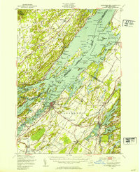
(14)- 1903 Map of Alexandria Bay
 1903 Alexandria Bay1903 Print · USGSThe Thousand Islands region appears here at the turn of the century as a burgeoning summer retreat along the international border. Genealogists and local historians can trace the early layouts of Alexandria Bay, the rail corridor through Redwood, and numerous island landings like Collins Landing.6 unique versions available
 - 1948 Map of Chippewa Bay
 1948 Chippewa Bay1948 Print · USGSThe Thousand Islands region along the St Lawrence River appears here in the late 1940s, split between the United States and Canada. Researchers can trace historical navigation markers like the Third Brother Lighthouse or locate local landmarks like School No 6 and Mallorytown.2 unique versions available
 - 1948 Map of Alexandria Bay, 1953 Print
 1948 Alexandria Bay1953 Print · USGSThe Thousand Islands region and the St. Lawrence River frontier are captured here in the late 1940s as international transit and local tourism flourished. Historians can trace the development of Alexandria Bay, the rural schools of Alexandria, and the lakeside settlements of Redwood and Plessis.2 unique versions available
 - 1948 Map of Ogdensburg, 1973 Print
 1948 Ogdensburg1973 Print · USGSThe international border along the St Lawrence River comes to life in the late 1940s, showing the vital rail and water connections between New York and Ontario. Researchers can trace the grounds of St Lawrence University, the massive Camp Drum military reservation, and the historic Rideau River and Canal.2 unique versions available
 - 1951 Map of Ogdensburg
 1951 Ogdensburg1951 Print · USGSThe St. Lawrence frontier and the North Country are captured here during the post-war era, from the river ports to the high Adirondacks. Genealogists and historians can trace the rail-and-river economy through Ogdensburg, the Rutland rail lines, and Potsdam.
 - 1953 Map of Ogdensburg
 1953 Ogdensburg1953 Print · USGSThe North Country and St. Lawrence Valley are shown here in the early fifties, just as the region’s rail-and-river economy remained in full swing. Genealogists and historians can trace family-named corners and rural hubs along the Rutland railroad or locate heritage sites near Ogdensburg, Potsdam, and the St Regis Indian Reservation.
 - 1958 Map of Chippewa Bay, 1960 Print
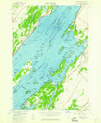 1958 Chippewa Bay1960 Print · USGSThe Thousand Islands shoreline of the St. Lawrence River comes alive in the late fifties, showing the intricate maze of channels and islands along the international border. Genealogists and divers can trace historic river access at Mallorytown Landing, locate local lights like Dark Island Light, and find family-named points such as Patterson Point.3 unique versions available
 - 1961 Map of Ogdensburg
 1961 Ogdensburg1961 Print · USGSThe St. Lawrence valley and the Adirondack high country meet in this early sixties survey during a peak era for rail and river commerce. Genealogists and historians can trace the paths of the New York Central railroad through remote settlements like Wanakena, Conifer, and Piercefield.
 - 1985 Map of Gouverneur
 1985 Gouverneur1985 Print · USGSSt. Lawrence and Jefferson Counties are shown in the mid-eighties as a landscape of river-driven industry and expanding military grounds. Genealogists and historians can trace rail lines through Carthage, find local landmarks like Noble Hospital, and locate the boundaries of the Fort Drum Military Reservation.2 unique versions available
 - 2011 Map of Chippewa Bay, 2011 Print
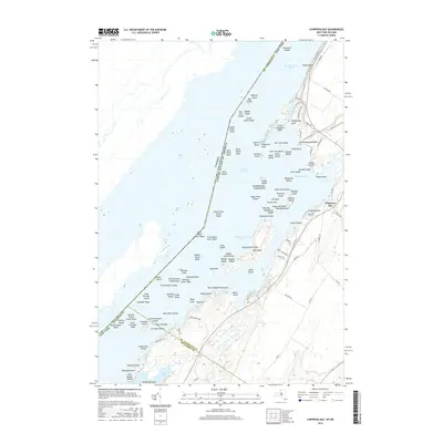
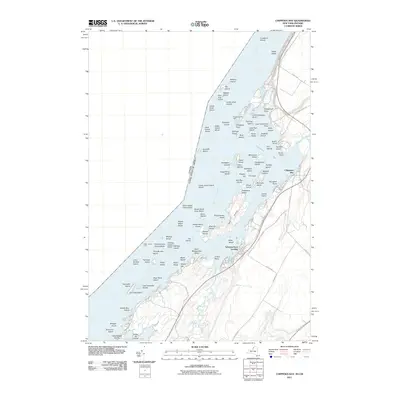 2011 Chippewa Bay2011 Print · USGSCovers Chippewa Bay, including Leeds and the Thousand Islands, Alexandria, and other nearby areas
 - 2013 Map of Chippewa Bay, 2013 Print
 2013 Chippewa Bay2013 Print · USGSCovers Chippewa Bay, including Leeds and the Thousand Islands, Alexandria, and other nearby areas
 - 2016 Map of Chippewa Bay, 2016 Print
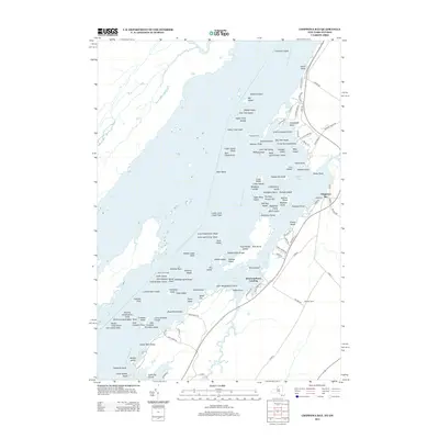
 2016 Chippewa Bay2016 Print · USGSCovers Chippewa Bay, including Leeds and the Thousand Islands, Alexandria, and other nearby areas
 - 2019 Map of Chippewa Bay, 2019 Print
 2019 Chippewa Bay2019 Print · USGSCovers Chippewa Bay, including Leeds and the Thousand Islands, Alexandria, and other nearby areas
 - 2023 Map of Chippewa Bay, 2023 Print
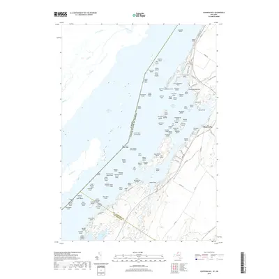
 2023 Chippewa Bay2023 Print · USGSThe Thousand Islands region along the Saint Lawrence River is captured here in contemporary detail. Trace family-named points and private islands from Chippewa Bay to Little Hammond Point and the quiet reaches of Goose Bay.
End of results
Showing maps 1-14 of 14
Top cities near Chippewa Bay
- Gouverneur historical maps
- Oswegatchie historical maps
- Alexandria historical maps
- Orleans historical maps
- Theresa historical maps
- Morristown historical maps
See more
Frequently asked questions
- What are the different types of historical maps available for Chippewa Bay?
- What is the oldest map of Chippewa Bay?
- Where can I purchase historical maps of Chippewa Bay for my home or office?
- Where can I download high-res historical maps of Chippewa Bay?
- Are there historical topographic maps available for Chippewa Bay?
- Is there historical aerial imagery available for Chippewa Bay?
- Where are historical maps of Chippewa Bay sourced from?