1940s Maps of Parishville, New York
Explore 7 historic maps of Parishville from the 1940s. These maps offer a rare glimpse into what life looked like during the 1940s — showing old roads, neighborhoods, homes, and landmarks that have changed or disappeared over time.
Whether you're researching your family's past, planning a metal detecting trip, or studying how Parishville's landscape evolved across the 1940s, these high-resolution maps are a powerful tool for exploring the history of this region.
- Focus on a specific era: All maps on this page are from the 1940s, giving you a focused view of this time period.
- See what’s changed: Compare century-old streets, trails, and buildings to today's modern landscape using overlays and satellite layers.
- Research with precision: Use these maps for genealogy, historical research, land use analysis, or educational projects.
- View, download, or print: Maps are fully viewable online in high resolution, and can be downloaded or printed for your own records.
Start exploring Parishville's history through authentic maps from the 1940s. This is your window into the past.
Parishville, NY maps
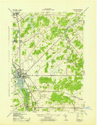
(7)- 1940 Map of Stark
 1940 Stark1940 Print · USGSSt. Lawrence County was a landscape of remote logging camps and private sporting clubs during the interwar years. Genealogists can locate family outposts like Sellecks Cors or trace the early rural education system at Littlejohn School and Cold Brook School.
 - 1942 Map of Long Bow, 1958 Print
 1942 Long Bow1958 Print · USGSSt. Lawrence County’s timbered foothills appear in detail during the early 1940s as the Raquette River flows toward the St. Lawrence. Researchers can locate remote schoolhouses like School No 6 and trace the original path of the Russell Turnpike Rd past Pickettsville.
 - 1943 Map of Potsdam
 1943 Potsdam1943 Print · USGSSt. Lawrence County during the early war years reveals a landscape of river-powered industry and dispersed school districts. Researchers can locate family heritage at Bayside Cem and St Marys Cem or trace the early industrial footprint of the Sugar Island Dam and the Garfield Gem mine.2 unique versions available
 - 1943 Map of Colton
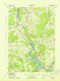 1943 Colton1943 Print · USGSSt. Lawrence County is shown during the early 1940s as its river-driven economy and rural school districts remained the heart of local life. Genealogists can trace family locations near Riverside Cem or find the numerous numbered schoolhouses serving Hannawa Falls and West Parishville.2 unique versions available
 - 1943 Map of Parishville
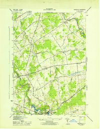 1943 Parishville1943 Print · USGSSt. Lawrence County during the early years of the war reveals a landscape of river-powered hamlets and numerous rural school districts. Researchers can trace family origins across the townships of Stockholm and Hopkinton or locate sites like Fairview Cem and Allens Falls Reservoir.2 unique versions available
 - 1943 Map of Long Bow
 1943 Long Bow1943 Print · USGSThe northern Adirondack foothills during the early 1940s reveal a landscape of river-driven industry and remote mountain schools. Researchers can trace the paths of the historic Russell Turnpike and locate several rural schoolhouses like School No. 11 and School No. 13.
 - 1948 Map of Ogdensburg, 1973 Print
 1948 Ogdensburg1973 Print · USGSThe international border along the St Lawrence River comes to life in the late 1940s, showing the vital rail and water connections between New York and Ontario. Researchers can trace the grounds of St Lawrence University, the massive Camp Drum military reservation, and the historic Rideau River and Canal.2 unique versions available
End of results
Showing maps 1-7 of 7
Top cities near Parishville
- Potsdam historical maps
- Canton historical maps
- Potsdam historical maps
- Norfolk historical maps
- Stockholm historical maps
- Moira historical maps
See more
Top neighborhoods of Parishville
- Willisville historical maps
- High Flats historical maps
- Pickettville historical maps
- West Parishville historical maps
- Parishville Center historical maps
- Sinclair Corner historical maps
See more
Frequently asked questions
- What are the different types of historical maps available for Parishville?
- What is the oldest map of Parishville?
- Where can I purchase historical maps of Parishville for my home or office?
- Where can I download high-res historical maps of Parishville?
- Are there historical topographic maps available for Parishville?
- Is there historical aerial imagery available for Parishville?
- Where are historical maps of Parishville sourced from?