Old Maps of Childwold, Piercefield for Academic Research
Study the evolution of Childwold with 14 high-resolution historic maps. Whether you're teaching, researching, or modeling changes in land use, these maps provide essential visual documentation of urban, environmental, and geographic change.
- Analyze long-term change: Track patterns in development, transportation, and natural features.
- Ideal for environmental or urban studies: Support academic projects with primary historical map data.
- Use in the classroom or lab: Educators and researchers rely on these maps to bring historical context to life.
These maps are a powerful tool for teaching, research, and visualizing how Childwold has changed over the decades.
Childwold, Piercefield maps
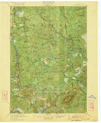
(14)- 1920 Map of Childwold, 1954 Print
 1920 Childwold1954 Print · USGSIn the Adirondack interior during the early 1920s, this area showcases a network of timber camps and early sporting clubs. Researchers can trace the riverfront development of Hollywood and Childwold, or locate landmarks like the Shur-leff Hotel and Kildare.2 unique versions available
 - 1921 Map of Childwold
 1921 Childwold1921 Print · USGSThe Adirondack wilderness in the early twenties was a landscape of remote sporting clubs and isolated river outposts. Genealogists and historians can trace old homesteads and landmarks like the Shurtleff Hotel, Childwold School, and the long-vanished community of Hollywood.
 - 1922 Map of Childwold
 1922 Childwold1922 Print · USGSThe St. Lawrence County wilderness in the early twenties is a landscape of isolated camps and early Adirondack outposts. Local historians can locate vanished sites like the Shurtleff Hotel or trace the early foundations of Childwold and Hollywood near the Jordan River.4 unique versions available
 - 1948 Map of Ogdensburg, 1973 Print
 1948 Ogdensburg1973 Print · USGSThe international border along the St Lawrence River comes to life in the late 1940s, showing the vital rail and water connections between New York and Ontario. Researchers can trace the grounds of St Lawrence University, the massive Camp Drum military reservation, and the historic Rideau River and Canal.2 unique versions available
 - 1951 Map of Ogdensburg
 1951 Ogdensburg1951 Print · USGSThe St. Lawrence frontier and the North Country are captured here during the post-war era, from the river ports to the high Adirondacks. Genealogists and historians can trace the rail-and-river economy through Ogdensburg, the Rutland rail lines, and Potsdam.
 - 1953 Map of Ogdensburg
 1953 Ogdensburg1953 Print · USGSThe North Country and St. Lawrence Valley are shown here in the early fifties, just as the region’s rail-and-river economy remained in full swing. Genealogists and historians can trace family-named corners and rural hubs along the Rutland railroad or locate heritage sites near Ogdensburg, Potsdam, and the St Regis Indian Reservation.
 - 1961 Map of Ogdensburg
 1961 Ogdensburg1961 Print · USGSThe St. Lawrence valley and the Adirondack high country meet in this early sixties survey during a peak era for rail and river commerce. Genealogists and historians can trace the paths of the New York Central railroad through remote settlements like Wanakena, Conifer, and Piercefield.
 - 1968 Map of Childwold, 1971 Print
 1968 Childwold1971 Print · USGSThe Raquette River wilderness in the late sixties reveals a network of remote hamlets and scout camps. Trace the developments at Childwold, identify family burial sites at the Cem near Sevey Corners, and locate the Lookout Tower on Moosehead Mtn.
 - 1985 Map of Tupper Lake, 1986 Print
 1985 Tupper Lake1986 Print · USGSThe Adirondacks in the mid-1980s reveal a network of mountain villages and timber-connected outposts. Researchers can trace the Adirondack RR through Saranac Lake or locate old industrial hamlets like Newton Falls and Gleasons Mill.2 unique versions available
 - 2010 Map of Childwold, 2010 Print
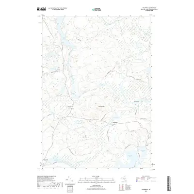
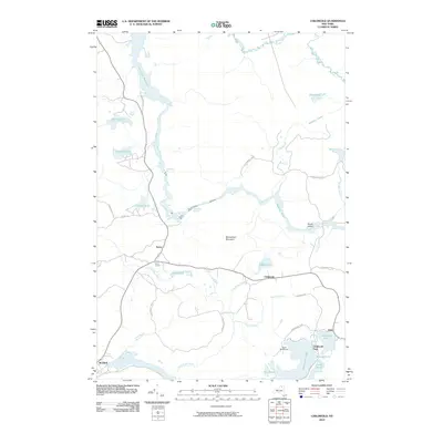 2010 Childwold2010 Print · USGSCovers Childwold, including Colton, Hopkinton, and other nearby areas
 - 2013 Map of Childwold, 2013 Print
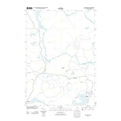 2013 Childwold2013 Print · USGSCovers Childwold, including Colton, Hopkinton, and other nearby areas
 - 2016 Map of Childwold, 2016 Print
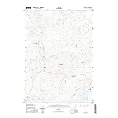 2016 Childwold2016 Print · USGSCovers Childwold, including Colton, Hopkinton, and other nearby areas
 - 2019 Map of Childwold, 2019 Print
 2019 Childwold2019 Print · USGSCovers Childwold, including Colton, Hopkinton, and other nearby areas
 - 2023 Map of Childwold, 2023 Print
 2023 Childwold2023 Print · USGSThe Adirondack wilderness of Saint Lawrence County comes into focus in this contemporary survey. Researchers can trace remote settlements like Childwold and Sevey or locate distinct landmarks such as Moosehead Mountain and Massawepie Lake.
End of results
Showing maps 1-14 of 14
Top cities near Childwold
- Tupper Lake historical maps
- Tupper Lake historical maps
- Parishville historical maps
- Webb historical maps
- Colton historical maps
- Hopkinton historical maps
See more
Frequently asked questions
- What are the different types of historical maps available for Childwold?
- What is the oldest map of Childwold?
- Where can I purchase historical maps of Childwold for my home or office?
- Where can I download high-res historical maps of Childwold?
- Are there historical topographic maps available for Childwold?
- Is there historical aerial imagery available for Childwold?
- Where are historical maps of Childwold sourced from?