Old Maps of Edinburg, New York for Genealogy
Trace your family roots with 63 historic maps of Edinburg. These high-res maps reveal old neighborhoods, homesites, landmarks, and streets — helping you uncover where your ancestors lived and how the area evolved over time.
- Explore historic neighborhoods: Identify where your relatives may have lived in the 1800s or 1900s.
- Compare maps over time: Trace the changes in streets, buildings, and landmarks for multi-generational research.
- Perfect for genealogy & ancestry research: Used by family historians and researchers to map out lineage and migration.
These maps are an incredible resource for exploring your personal connection to Edinburg's past.
Edinburg, NY maps
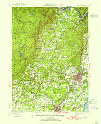
(63)- 1899 Map of Broadalbin, 1954 Print
 1899 Broadalbin1954 Print · USGSFulton and Saratoga counties are shown here just before the turn of the century as the local economy balanced rail transport and river-powered industry. Genealogists can trace family roots through numerous mill hamlets and settlements like Northampton, Vail Mills, and Osborn Bridge.
 - 1902 Map of Broadalbin
 1902 Broadalbin1902 Print · USGSThe Sacandaga River valley is shown here at the turn of the century, prior to the major hydroelectric projects that reshaped this Fulton County landscape. Genealogists can trace early homesteads and milling sites near Vail Mills, Hagedorns Mills, and the Sacandaga Park rail terminus.9 unique versions available
 - 1902 Map of Saratoga
 1902 Saratoga1902 Print · USGSSaratoga County at the turn of the century reveals a landscape defined by famous spa towns and a dense web of steam and electric railways. Trace early property locations and transport routes in Saratoga Springs, Ballston Spa, and Rock City Falls.9 unique versions available
 - 1903 Map of Luzerne
 1903 Luzerne1903 Print · USGSSouthern Warren County is documented here at the turn of the century as the rail and timber economy flourished. Local historians can trace the early layouts of Luzerne and Hadley or locate vanished sites near Conklingville and Linwood.8 unique versions available
 - 1910 Map of Stony Creek
 1910 Stony Creek1910 Print · USGSThe southern Adirondacks at the turn of the century are captured here, centered on the intersection of Hamilton, Warren, and Saratoga counties. Genealogists can trace early outposts and hamlets like Harrisburg West Stony Creek PO, Hope Falls, and Griffin.7 unique versions available
 - 1942 Map of Saratoga
 1942 Saratoga1942 Print · USGSSaratoga and the foothills of the Adirondacks are captured in the late 1930s, documenting a landscape of grand estates and growing paper-mill towns. Genealogists can trace family names through rural landmarks like Daketown Sch, Malta Ridge Cem, and Rock City Falls.2 unique versions available
 - 1945 Map of Edinburg, 1962 Print
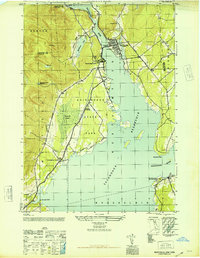
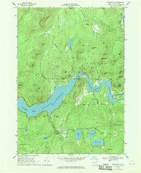
 1945 Edinburg1962 Print · USGSSaratoga County's southern Adirondack foothills were transitioning toward a reservoir-centered economy in the mid-1940s. Genealogists and hikers can trace old family burial sites like Partridge Cem or locate the small settlement of Glenwild and the Plateau Airport.
 - 1945 Map of Northville, 1962 Print
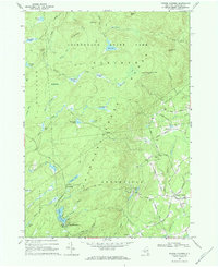
 1945 Northville1962 Print · USGSThe foothills of the Adirondacks meet the expanding reservoir in the mid-1940s, showing the vital connections between mountain valleys and the river. Genealogists can locate family burial sites at King Cem and Gifford Valley Cem or trace the early layout of Northville and Fish House.
 - 1946 Map of Edinburg
 1946 Edinburg1946 Print · USGSSaratoga County in the mid-forties reveals a landscape transformed by the flooding of the Sacandaga Reservoir. Genealogists and local historians can trace family plots at Partridge Cem or explore the hills near Batchellerville and Glenwild.
 - 1946 Map of Northville
 1946 Northville1946 Print · USGSThe southern Adirondacks at the conclusion of the second World War reveal a landscape shaped by the new reservoir and traditional rail lines. Researchers can trace the F J & G RR through Sacandaga Park and locate historic burial sites like Christie Cem and King Cem.
 - 1947 Map of Saratoga, 1955 Print
 1947 Saratoga1955 Print · USGSSaratoga County was a hub of sport and industry in the late 1940s, from the famous racing grounds to the paper mill villages. Researchers can trace the mid-century footprints of SKIDMORE COLLEGE, the SARATOGA RACEWAY, and local landmarks like the COUNTY HOME.3 unique versions available
 - 1949 Map of Saratoga
 1949 Saratoga1949 Print · USGSSaratoga Springs and the surrounding Adirondack foothills are shown here in the mid-century, capturing a world of historic horse racing and rural industry. Researchers can trace family roots through numerous local landmarks like Ballou Cem, Middle Grove, and the Boyhaven Boy Scout Camp.
 - 1950 Map of Glens Falls
 1950 Glens Falls1950 Print · USGSThe Adirondacks and the Green Mountains meet in this mid-century survey of the New York and Vermont borderlands. Researchers can trace the industrial rail corridors of the Rutland RR and Delaware & Hudson RR connecting Glens Falls, Rutland, and the shores of Lake George.
 - 1950 Map of Utica, 1951 Print
 1950 Utica1951 Print · USGSCentral New York in the post-war era showcases the industrial Mohawk Valley and the pristine Adirondack interior. Researchers can trace transportation networks like the New York Central Railroad and find early Cold War sites such as Griffiss Air Force Base.
 - 1954 Map of Harrisburg, 1958 Print
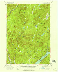 1954 Harrisburg1958 Print · USGSThe Adirondack foothills and the Sacandaga valley appear here in the mid-fifties, showing a landscape defined by mountain hamlets and seasonal camps. Researchers can trace family history through sites like Scofield Cem, the Edinburg Ch, and the remote settlement of Griffin.5 unique versions available
 - 1955 Map of Lake Luzerne, 1957 Print
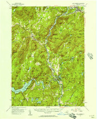 1955 Lake Luzerne1957 Print · USGSThe southern Adirondacks in the mid-1950s show a landscape shaped by the Hudson River and the expanding Sacandaga Reservoir. Genealogists and historians can trace rail stops like Stony Creek Sta, local burials at Harris Cem, and the early layout of Lake Luzerne.4 unique versions available
 - 1956 Map of Glens Falls, 1968 Print
 1956 Glens Falls1968 Print · USGSUpper New York and the Vermont mountains are captured here in the mid-fifties, showing the rugged rail-and-river network of the Northeast. Researchers can trace the paths of the Delaware and Hudson RR and Rutland RR as they wind through valley towns like Poultney and Whitehall.3 unique versions available
 - 1957 Map of Utica
 1957 Utica1957 Print · USGSCentral New York and the Adirondack foothills are captured here in the mid-fifties, showing a landscape defined by the Mohawk River corridor and the growing highway system. Genealogists and researchers can trace the rail lines of the New York Central and locate communities from Lowville to Gloversville.
 - 1959 Map of Glens Falls
 1959 Glens Falls1959 Print · USGSUpper New York and Vermont are captured here during the late 1950s, a period of transition for these mountain communities. Researchers can trace the legacy of the region's river-and-rail economy through landmarks like Lake George, Saratoga Springs, and Killington Peak.2 unique versions available
 - 1962 Map of Utica
 1962 Utica1962 Print · USGSCentral New York and the Adirondack wilderness are captured here during the mid-century era of highway and industrial expansion. Genealogists and historians can trace the development of the New York State Thruway and local rail lines connecting Utica, Rome, and Gloversville.3 unique versions available
 - 1964 Map of Glens Falls
 1964 Glens Falls1964 Print · USGSThe tri-state borderlands of New York, Vermont, and New Hampshire appear here in the mid-1960s. Researchers can trace the rail routes of the Rutland RR and find historic sites like Ticonderoga and Saratoga National Historical Park.
 - 1964 Map of Utica
 1964 Utica1964 Print · USGSCentral New York and the high wilderness of the Adirondacks are captured here during the post-war era of infrastructure expansion. Researchers can trace the development of the New York State Thruway alongside historic corridors like the Oneida Lake (Barge Canal Route) and the N. Y. Central railroad.
 - 1966 Map of Conklingville, 1970 Print
 1966 Conklingville1970 Print · USGSSaratoga County was a landscape defined by water and timber in the mid-sixties, dominated by the massive Sacandaga Reservoir. Genealogists and historians can trace old mountain roads and family landmarks like Sandpit Cem, Hunt Lake, and the hamlet of Conklingville.2 unique versions available
 - 1967 Map of Utica
 1967 Utica1967 Print · USGSCentral New York's industrial Mohawk Valley meets the Adirondack wilderness in the 1960s, showing the region's transition from manufacturing hubs to state-managed parklands. Trace historic settlements and sites like Griffiss Air Force Base, Colgate University, and the Lyons Falls Paper Mill.
 - 1968 Map of Porter Corners, 1969 Print
 1968 Porter Corners1969 Print · USGSSaratoga County's wooded hills and wetlands are shown in detail during the late sixties, highlighting the rural transition into the mountains. Genealogists and hikers can locate family landmarks like Wells Cem and the prominent Lookout Tower on Spruce Mtn.2 unique versions available
Showing maps 1-25 of 63
Top cities near Edinburg
- Saratoga Springs historical maps
- Milton historical maps
- Greenfield historical maps
- Corinth historical maps
- Mayfield historical maps
- Broadalbin historical maps
See more
Top neighborhoods of Edinburg
- Clarkville historical maps
- West Day historical maps
- Fox Hill historical maps
- Batchellerville historical maps
- Tennantville historical maps
Frequently asked questions
- What are the different types of historical maps available for Edinburg?
- What is the oldest map of Edinburg?
- Where can I purchase historical maps of Edinburg for my home or office?
- Where can I download high-res historical maps of Edinburg?
- Are there historical topographic maps available for Edinburg?
- Is there historical aerial imagery available for Edinburg?
- Where are historical maps of Edinburg sourced from?