1940s Maps of Edinburg, New York
Explore 7 historic maps of Edinburg from the 1940s. These maps offer a rare glimpse into what life looked like during the 1940s — showing old roads, neighborhoods, homes, and landmarks that have changed or disappeared over time.
Whether you're researching your family's past, planning a metal detecting trip, or studying how Edinburg's landscape evolved across the 1940s, these high-resolution maps are a powerful tool for exploring the history of this region.
- Focus on a specific era: All maps on this page are from the 1940s, giving you a focused view of this time period.
- See what’s changed: Compare century-old streets, trails, and buildings to today's modern landscape using overlays and satellite layers.
- Research with precision: Use these maps for genealogy, historical research, land use analysis, or educational projects.
- View, download, or print: Maps are fully viewable online in high resolution, and can be downloaded or printed for your own records.
Start exploring Edinburg's history through authentic maps from the 1940s. This is your window into the past.
Edinburg, NY maps
(7)- 1942 Map of Saratoga
 1942 Saratoga1942 Print · USGSSaratoga and the foothills of the Adirondacks are captured in the late 1930s, documenting a landscape of grand estates and growing paper-mill towns. Genealogists can trace family names through rural landmarks like Daketown Sch, Malta Ridge Cem, and Rock City Falls.2 unique versions available
 - 1945 Map of Edinburg, 1962 Print
 1945 Edinburg1962 Print · USGSSaratoga County's southern Adirondack foothills were transitioning toward a reservoir-centered economy in the mid-1940s. Genealogists and hikers can trace old family burial sites like Partridge Cem or locate the small settlement of Glenwild and the Plateau Airport.
 - 1945 Map of Northville, 1962 Print
 1945 Northville1962 Print · USGSThe foothills of the Adirondacks meet the expanding reservoir in the mid-1940s, showing the vital connections between mountain valleys and the river. Genealogists can locate family burial sites at King Cem and Gifford Valley Cem or trace the early layout of Northville and Fish House.
 - 1946 Map of Edinburg
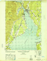
 1946 Edinburg1946 Print · USGSSaratoga County in the mid-forties reveals a landscape transformed by the flooding of the Sacandaga Reservoir. Genealogists and local historians can trace family plots at Partridge Cem or explore the hills near Batchellerville and Glenwild.
 - 1946 Map of Northville
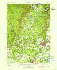
 1946 Northville1946 Print · USGSThe southern Adirondacks at the conclusion of the second World War reveal a landscape shaped by the new reservoir and traditional rail lines. Researchers can trace the F J & G RR through Sacandaga Park and locate historic burial sites like Christie Cem and King Cem.
 - 1947 Map of Saratoga, 1955 Print
 1947 Saratoga1955 Print · USGSSaratoga County was a hub of sport and industry in the late 1940s, from the famous racing grounds to the paper mill villages. Researchers can trace the mid-century footprints of SKIDMORE COLLEGE, the SARATOGA RACEWAY, and local landmarks like the COUNTY HOME.3 unique versions available
 - 1949 Map of Saratoga
 1949 Saratoga1949 Print · USGSSaratoga Springs and the surrounding Adirondack foothills are shown here in the mid-century, capturing a world of historic horse racing and rural industry. Researchers can trace family roots through numerous local landmarks like Ballou Cem, Middle Grove, and the Boyhaven Boy Scout Camp.
End of results
Showing maps 1-7 of 7
Top cities near Edinburg
- Saratoga Springs historical maps
- Milton historical maps
- Greenfield historical maps
- Corinth historical maps
- Mayfield historical maps
- Broadalbin historical maps
See more
Top neighborhoods of Edinburg
- Clarkville historical maps
- West Day historical maps
- Fox Hill historical maps
- Batchellerville historical maps
- Tennantville historical maps
Frequently asked questions
- What are the different types of historical maps available for Edinburg?
- What is the oldest map of Edinburg?
- Where can I purchase historical maps of Edinburg for my home or office?
- Where can I download high-res historical maps of Edinburg?
- Are there historical topographic maps available for Edinburg?
- Is there historical aerial imagery available for Edinburg?
- Where are historical maps of Edinburg sourced from?