1960s Maps of Providence, New York
Explore 6 historic maps of Providence from the 1960s. These maps offer a rare glimpse into what life looked like during the 1960s — showing old roads, neighborhoods, homes, and landmarks that have changed or disappeared over time.
Whether you're researching your family's past, planning a metal detecting trip, or studying how Providence's landscape evolved across the 1960s, these high-resolution maps are a powerful tool for exploring the history of this region.
- Focus on a specific era: All maps on this page are from the 1960s, giving you a focused view of this time period.
- See what’s changed: Compare century-old streets, trails, and buildings to today's modern landscape using overlays and satellite layers.
- Research with precision: Use these maps for genealogy, historical research, land use analysis, or educational projects.
- View, download, or print: Maps are fully viewable online in high resolution, and can be downloaded or printed for your own records.
Start exploring Providence's history through authentic maps from the 1960s. This is your window into the past.
Providence, NY maps
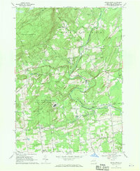
(6)- 1962 Map of Utica
 1962 Utica1962 Print · USGSCentral New York and the Adirondack wilderness are captured here during the mid-century era of highway and industrial expansion. Genealogists and historians can trace the development of the New York State Thruway and local rail lines connecting Utica, Rome, and Gloversville.3 unique versions available
 - 1964 Map of Glens Falls
 1964 Glens Falls1964 Print · USGSThe tri-state borderlands of New York, Vermont, and New Hampshire appear here in the mid-1960s. Researchers can trace the rail routes of the Rutland RR and find historic sites like Ticonderoga and Saratoga National Historical Park.
 - 1964 Map of Utica
 1964 Utica1964 Print · USGSCentral New York and the high wilderness of the Adirondacks are captured here during the post-war era of infrastructure expansion. Researchers can trace the development of the New York State Thruway alongside historic corridors like the Oneida Lake (Barge Canal Route) and the N. Y. Central railroad.
 - 1967 Map of Utica
 1967 Utica1967 Print · USGSCentral New York's industrial Mohawk Valley meets the Adirondack wilderness in the 1960s, showing the region's transition from manufacturing hubs to state-managed parklands. Trace historic settlements and sites like Griffiss Air Force Base, Colgate University, and the Lyons Falls Paper Mill.
 - 1967 Map of Middle Grove, 1971 Print
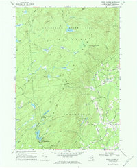
 1967 Middle Grove1971 Print · USGSSaratoga County in the late sixties reveals a landscape of rural crossroads and high-tech defense installations. Genealogists and historians can trace family-named corners like Chatfield Corner or the specialized grounds of the Knolls Atomic Energy Plant.2 unique versions available
 - 1968 Map of Porter Corners, 1969 Print
 1968 Porter Corners1969 Print · USGSSaratoga County's wooded hills and wetlands are shown in detail during the late sixties, highlighting the rural transition into the mountains. Genealogists and hikers can locate family landmarks like Wells Cem and the prominent Lookout Tower on Spruce Mtn.2 unique versions available
End of results
Showing maps 1-6 of 6
Top cities near Providence
- Clifton Park historical maps
- Rotterdam historical maps
- Glenville historical maps
- West Glenville historical maps
- Saratoga Springs historical maps
- Milton historical maps
See more
Top neighborhoods of Providence
- Fayville historical maps
- Glenwild historical maps
- Green Corners historical maps
- Shaw Corners historical maps
- Barkersville historical maps
- Hagedorns Mills historical maps
Frequently asked questions
- What are the different types of historical maps available for Providence?
- What is the oldest map of Providence?
- Where can I purchase historical maps of Providence for my home or office?
- Where can I download high-res historical maps of Providence?
- Are there historical topographic maps available for Providence?
- Is there historical aerial imagery available for Providence?
- Where are historical maps of Providence sourced from?