1960s Maps of Thompson, New York
Explore 8 historic maps of Thompson from the 1960s. These maps offer a rare glimpse into what life looked like during the 1960s — showing old roads, neighborhoods, homes, and landmarks that have changed or disappeared over time.
Whether you're researching your family's past, planning a metal detecting trip, or studying how Thompson's landscape evolved across the 1960s, these high-resolution maps are a powerful tool for exploring the history of this region.
- Focus on a specific era: All maps on this page are from the 1960s, giving you a focused view of this time period.
- See what’s changed: Compare century-old streets, trails, and buildings to today's modern landscape using overlays and satellite layers.
- Research with precision: Use these maps for genealogy, historical research, land use analysis, or educational projects.
- View, download, or print: Maps are fully viewable online in high resolution, and can be downloaded or printed for your own records.
Start exploring Thompson's history through authentic maps from the 1960s. This is your window into the past.
Thompson, NY maps
(8)- 1962 Map of Scranton, 1977 Print
 1962 Scranton1977 Print · USGSThe industrial heart of eastern Pennsylvania and the New York Catskills are captured here in the early sixties. Genealogists and historians can trace the dense valley settlements from Scranton to Wilkes-Barre and the rail lines of the Erie Lackawanna Railroad.2 unique versions available
 - 1965 Map of Scranton
 1965 Scranton1965 Print · USGSThe tri-state highlands of Pennsylvania, New York, and New Jersey come alive in the mid-sixties as industry and recreation converge. Trace the intricate rail lines of the Erie Lackawanna RR or locate landmarks like the U S Military Academy.2 unique versions available
 - 1966 Map of Hartwood, 1967 Print
 1966 Hartwood1967 Print · USGSForestburg and the Neversink River valley are shown in the mid-1960s as a landscape of wooded hills and private sporting clubs. Genealogists and local historians can trace the foundations of Oakland Valley, locate St Thomas Cem, or follow the Old Railroad Grade near Philwold.2 unique versions available
 - 1966 Map of Yankee Lake, 1968 Print
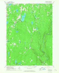
 1966 Yankee Lake1968 Print · USGSSullivan County in the mid-1960s was a landscape defined by its canal history and growing lakeside retreats. Trace the length of the Delaware and Hudson Canal (Abandoned) or locate family landmarks like Belle Terre Cem and Mamakating Park.3 unique versions available
 - 1966 Map of Woodridge, 1968 Print
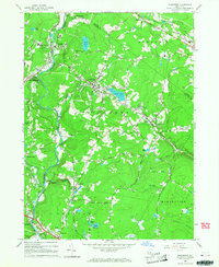 1966 Woodridge1968 Print · USGSSullivan County in the mid-1960s reveals a transition from traditional rural life to a burgeoning recreation and institutional hub. Genealogists can trace family connections through landmarks like Hillside Cem, Mountain Dale, and the Central High Sch near Woodridge.2 unique versions available
 - 1966 Map of Monticello, 1968 Print
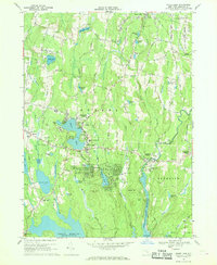
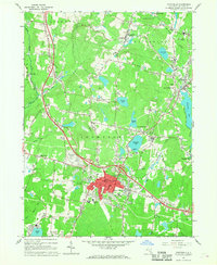 1966 Monticello1968 Print · USGSSullivan County’s mid-century resort culture is on full display here, centered on the growing village of Monticello. Researchers can trace old family landmarks and institutions like Kutshers Country Club, Brookside Cem, and the Sullivan County Community College.3 unique versions available
 - 1967 Map of White Lake, 1969 Print
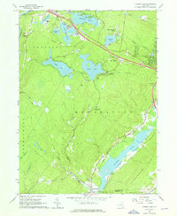
 1967 White Lake1969 Print · USGSSullivan County’s lake country is captured here during its mid-century heyday as a premier summer destination. Researchers can trace family-named landmarks and local institutions, from Temple Beth El and Lyon Cem to the early footprints of Smallwood and Bethel.2 unique versions available
 - 1967 Map of Highland Lake, 1969 Print
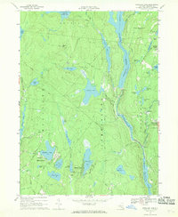 1967 Highland Lake1969 Print · USGSSullivan County in the late sixties reveals a landscape of massive hydroelectric projects and quiet summer colonies. Genealogists and hikers can trace the paths between Forestburg, the Forestburg Cemetery, and secluded landmarks like Cordes Chapel.2 unique versions available
End of results
Showing maps 1-8 of 8
Top cities near Thompson
- Wallkill historical maps
- Middletown historical maps
- Goshen historical maps
- Fallsburg historical maps
- Wawarsing historical maps
- Mamakating historical maps
See more
Top neighborhoods of Thompson
- Harris historical maps
- Maplewood historical maps
- Coopers Corners historical maps
- Melody Lake historical maps
- Thompsonville historical maps
- Monticello historical maps
See more
Frequently asked questions
- What are the different types of historical maps available for Thompson?
- What is the oldest map of Thompson?
- Where can I purchase historical maps of Thompson for my home or office?
- Where can I download high-res historical maps of Thompson?
- Are there historical topographic maps available for Thompson?
- Is there historical aerial imagery available for Thompson?
- Where are historical maps of Thompson sourced from?