1950s Maps of Barton, New York
Explore 10 historic maps of Barton from the 1950s. These maps offer a rare glimpse into what life looked like during the 1950s — showing old roads, neighborhoods, homes, and landmarks that have changed or disappeared over time.
Whether you're researching your family's past, planning a metal detecting trip, or studying how Barton's landscape evolved across the 1950s, these high-resolution maps are a powerful tool for exploring the history of this region.
- Focus on a specific era: All maps on this page are from the 1950s, giving you a focused view of this time period.
- See what’s changed: Compare century-old streets, trails, and buildings to today's modern landscape using overlays and satellite layers.
- Research with precision: Use these maps for genealogy, historical research, land use analysis, or educational projects.
- View, download, or print: Maps are fully viewable online in high resolution, and can be downloaded or printed for your own records.
Start exploring Barton's history through authentic maps from the 1950s. This is your window into the past.
Barton, NY maps
(10)- 1950 Map of Elmira
 1950 Elmira1950 Print · USGSThe Finger Lakes region thrived in the late 1940s as a hub of industry and transport. Trace family roots and vanished landmarks near Seneca Lake or explore the rail lines of the Erie RR and the sprawling Seneca Ordnance Depot.2 unique versions available
 - 1953 Map of Barton, 1955 Print
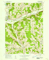
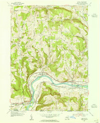 1953 Barton1955 Print · USGSThe Susquehanna River valley thrived as a heavy rail corridor in the mid-1950s, connecting New York and Pennsylvania. Genealogists can trace family names through landmarks like Oak Hill Cem, Emory Chapel, and the hamlet of Hoopers Valley.
 - 1954 Map of Williamsport
 1954 Williamsport1954 Print · USGSNorth-central Pennsylvania in the mid-fifties is defined by the winding West Branch Susquehanna River and its industrial valley. Local historians can trace the massive Susquehanna Ordnance Depot and the extensive rail networks of the Pennsylvania Railroad.
 - 1954 Map of Waverly, 1956 Print
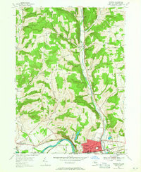 1954 Waverly1956 Print · USGSThe village of Waverly appears here as a bustling rail crossroads during the mid-fifties, situated right at the New York and Pennsylvania state line. You can trace the legacy of early settlements and rural infrastructure through Owens Mill, the Bogart Hill Sch, and the winding tracks of the Lehigh Valley railroad.2 unique versions available
 - 1954 Map of Van Etten, 1956 Print
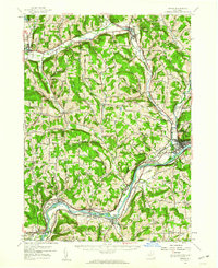
 1954 Van Etten1956 Print · USGSChemung and Tioga Counties are seen here in the mid-1950s, centered on the vital rail junction at Van Etten. Genealogists and local historians can trace family-named sites like Rumsey Cem, Hicks, and landmarks along the Lehigh Valley line.
 - 1954 Map of Waverly, 1961 Print
 1954 Waverly1961 Print · USGSThe Southern Tier's river valleys and rail networks are caught at a mid-century peak in this survey of Tioga and Chemung counties. Genealogists can trace family names through landmarks like Austin Hill Cem, the Double Mill Sch, and the historical Newtown Battlefield State Park.2 unique versions available
 - 1956 Map of Spencer, 1958 Print
 1956 Spencer1958 Print · USGSTioga County in the mid-fifties remains a landscape of high ridges and narrow creek valleys centered on the village of Spencer. Genealogists can trace rural homesteads near the Hamilton Sch and follow the old winding routes between Halsey Valley and Straits Corners Ch.
 - 1956 Map of Owego, 1960 Print
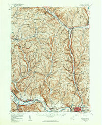
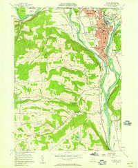
 1956 Owego1960 Print · USGSTioga County in the mid-1950s is defined by its deep river valleys and the busy corridors of the Erie Railroad and Lehigh Valley Railroad. Genealogists and historians can trace the foundations of local life through rural landmarks like Hamilton Sch and the Sulphur Springs Chapel.
 - 1957 Map of Sayre, 1958 Print
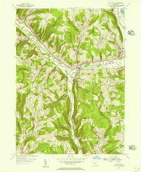
 1957 Sayre1958 Print · USGSThe Susquehanna and Chemung rivers meet in this late 1950s survey of the northern Pennsylvania border. Researchers can trace the industrial footprint of the Lehigh Valley RR, locate the Milan Cem, or explore old river landings like Greenes Landing.4 unique versions available
 - 1958 Map of Elmira
 1958 Elmira1958 Print · USGSThe New York Finger Lakes during the late fifties reveal a complex landscape of glacial geology and industrial growth. Researchers can trace historic transport corridors like the Erie Canal and Erie RR, or locate institutional landmarks like Cornell University.2 unique versions available
End of results
Showing maps 1-10 of 10
Top cities near Barton
- Owego historical maps
- Elmira historical maps
- Sayre historical maps
- Candor historical maps
- Newfield historical maps
- Tioga historical maps
See more
Top neighborhoods of Barton
- North Barton historical maps
- Glencairn historical maps
- North Waverly historical maps
- Reniff historical maps
- Lockwood historical maps
- Ellistown historical maps
See more
Frequently asked questions
- What are the different types of historical maps available for Barton?
- What is the oldest map of Barton?
- Where can I purchase historical maps of Barton for my home or office?
- Where can I download high-res historical maps of Barton?
- Are there historical topographic maps available for Barton?
- Is there historical aerial imagery available for Barton?
- Where are historical maps of Barton sourced from?