2020s Maps of Barton, New York
Explore 6 historic maps of Barton from the 2020s. These maps offer a rare glimpse into what life looked like during the 2020s — showing old roads, neighborhoods, homes, and landmarks that have changed or disappeared over time.
Whether you're researching your family's past, planning a metal detecting trip, or studying how Barton's landscape evolved across the 2020s, these high-resolution maps are a powerful tool for exploring the history of this region.
- Focus on a specific era: All maps on this page are from the 2020s, giving you a focused view of this time period.
- See what’s changed: Compare century-old streets, trails, and buildings to today's modern landscape using overlays and satellite layers.
- Research with precision: Use these maps for genealogy, historical research, land use analysis, or educational projects.
- View, download, or print: Maps are fully viewable online in high resolution, and can be downloaded or printed for your own records.
Start exploring Barton's history through authentic maps from the 2020s. This is your window into the past.
Barton, NY maps
(6)- 2023 Map of Sayre, 2023 Print
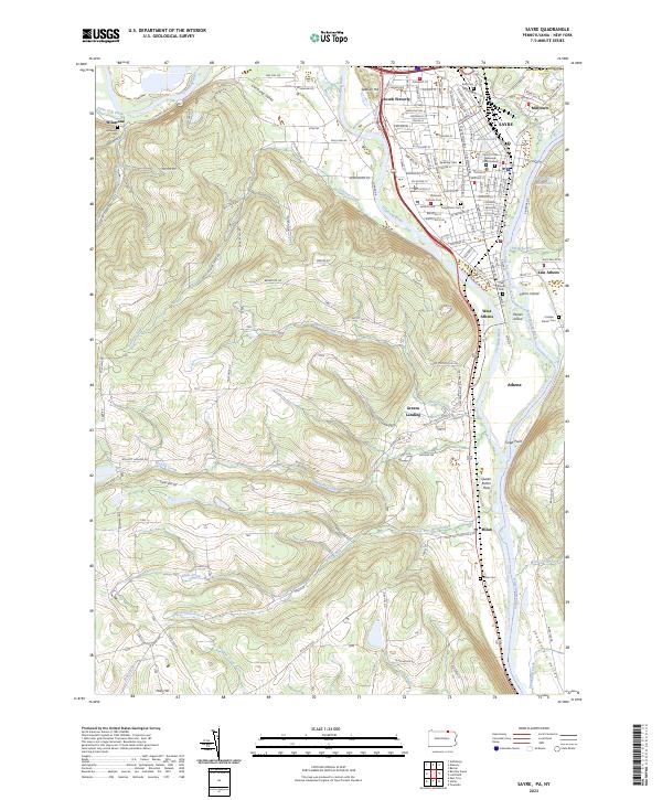 2023 Sayre2023 Print · USGSThe confluence of the Chemung River and Susquehanna River highlights this late-era survey of the Penn-York border. Researchers can trace family history at Tioga Point Cemetery, the Queen Esther Flats, and the older Old Athens Cemetery.
 - 2023 Map of Van Etten, 2023 Print
 2023 Van Etten2023 Print · USGSThe Southern Tier highlands come into focus during the early twenty-first century, centered on the rail-and-creek junction at Van Etten. Genealogists can trace family landmarks and rural homesteads through Swartwood Cem, Jenkins Cem, and the high reaches of Nobles Hill.
 - 2023 Map of Spencer, 2023 Print
 2023 Spencer2023 Print · USGSTioga County's southern tier remains a landscape of deep valleys and historic rural outposts in this modern survey. Genealogists can trace family names at Baptist Society Cem and Halsey Valley Cem, or explore the crossroads at Spencer and Straits Corners.
 - 2023 Map of Litchfield, 2023 Print
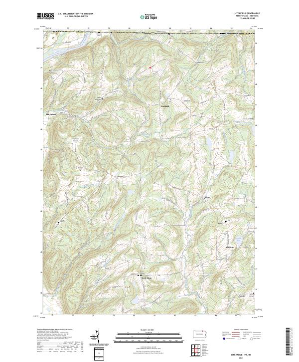 2023 Litchfield2023 Print · USGSThe Pennsylvania-New York borderlands are shown here in recent detail, where the Susquehanna River meets the high ridges of Bradford County. Genealogists can locate family burial sites at the Merrill Family Cem or trace old routes through Bumpville and North Ghent.
 - 2023 Map of Barton, 2023 Print
 2023 Barton2023 Print · USGSTioga County's riverfront and upland ridges come into sharp focus in this detailed survey of the southern Tier. Genealogists can locate family burial sites at Asbury Church Cem and Light Cem, or trace the winding course of Flag Marsh Run through Ellistown.
 - 2023 Map of Waverly, 2023 Print
 2023 Waverly2023 Print · USGSTioga County settlement and the Chemung River valley are captured in this modern survey of the New York-Pennsylvania border. Genealogists can locate numerous burial sites such as Price-Simcoe Cem and French Cem near the village of Waverly.
End of results
Showing maps 1-6 of 6
Top cities near Barton
- Owego historical maps
- Elmira historical maps
- Sayre historical maps
- Candor historical maps
- Newfield historical maps
- Tioga historical maps
See more
Top neighborhoods of Barton
- North Barton historical maps
- Glencairn historical maps
- North Waverly historical maps
- Reniff historical maps
- Lockwood historical maps
- Ellistown historical maps
See more
Frequently asked questions
- What are the different types of historical maps available for Barton?
- What is the oldest map of Barton?
- Where can I purchase historical maps of Barton for my home or office?
- Where can I download high-res historical maps of Barton?
- Are there historical topographic maps available for Barton?
- Is there historical aerial imagery available for Barton?
- Where are historical maps of Barton sourced from?