1940s Maps of West Hebron, Hebron
Explore 2 historic maps of West Hebron from the 1940s. These maps offer a rare glimpse into what life looked like during the 1940s — showing old roads, neighborhoods, homes, and landmarks that have changed or disappeared over time.
Whether you're researching your family's past, planning a metal detecting trip, or studying how West Hebron's landscape evolved across the 1940s, these high-resolution maps are a powerful tool for exploring the history of this region.
- Focus on a specific era: All maps on this page are from the 1940s, giving you a focused view of this time period.
- See what’s changed: Compare century-old streets, trails, and buildings to today's modern landscape using overlays and satellite layers.
- Research with precision: Use these maps for genealogy, historical research, land use analysis, or educational projects.
- View, download, or print: Maps are fully viewable online in high resolution, and can be downloaded or printed for your own records.
Start exploring West Hebron's history through authentic maps from the 1940s. This is your window into the past.
West Hebron, Hebron maps
(2)- 1944 Map of Cossayuna, 1958 Print
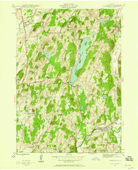 1944 Cossayuna1958 Print · USGSWashington County's rural character is on full display in the mid-1940s, showing a landscape defined by upland lakes and valley farms. Genealogists can trace family names through the Argyle Cem, visit the County Farm, or follow the Greenwich and Johnsonville rail line.3 unique versions available
 - 1946 Map of Cossayuna
 1946 Cossayuna1946 Print · USGSWashington County at the end of the Second World War shows a rural landscape of ridge-top farms and valley settlements centered around Cossayuna Lake. Genealogists can locate family-named landmarks and old institutions like the County Farm and Rock Hill Sch.
End of results
Showing maps 1-2 of 2
Top cities near West Hebron
- Queensbury historical maps
- Moreau historical maps
- Kingsbury historical maps
- Stillwater historical maps
- Hudson Falls historical maps
- Granville historical maps
See more
Frequently asked questions
- What are the different types of historical maps available for West Hebron?
- What is the oldest map of West Hebron?
- Where can I purchase historical maps of West Hebron for my home or office?
- Where can I download high-res historical maps of West Hebron?
- Are there historical topographic maps available for West Hebron?
- Is there historical aerial imagery available for West Hebron?
- Where are historical maps of West Hebron sourced from?