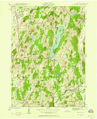
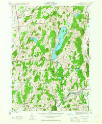
1944 Map of Cossayuna
USGS Topo · Published 1958About this map
Cossayuna Lake serves as the central focal point of this Washington County landscape, which transitions from the agricultural flats of Argyle to the prominent ridges of Barkley Mtn. During the mid-1940s, this region was a tapestry of rural hamlets and small-scale industry, evidenced by the Greenwich and Johnsonville railroad line tracing the path of the Batten Kill in the south. The prevalence of local education and community infrastructure is clear through the presence of the Rock Hill Sch, Beech Hill Sch, and the County Farm near South Argyle. Water bodies like McDougall Lake and Carter Pond punctuate the valleys, while the numerous cemeteries, including the Cossayuna Cem, provide a grounded record of the families who settled this territory between West Hebron and North Greenwich.
Find a feature on this map
39 named features on this map. Tap any name to fly to it.
Don’t see what you’re looking for? This feature index may not catch every label — zoom into the map to look around manually.
Map Details
Editions of this 1944 Cossayuna Map

Other maps of this area

1893 · Fort Ann
USGS Topo · 1:62,500

1895 · Cambridge
USGS Topo · 1:62,500

1895 · Fort Ann
USGS Topo · 1:62,500

1895 · Glens Falls
USGS Topo · 1:62,500

1897 · Glens Falls
USGS Topo · 1:62,500

1898 · Cambridge
USGS Topo · 1:62,500

1898 · Fort Ann
USGS Topo · 1:62,500

1900 · Schuylerville
USGS Topo · 1:62,500

1901 · Fort Ann
USGS Topo · 1:62,500

1901 · Cambridge
USGS Topo · 1:62,500