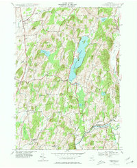
1944 Map of Cossayuna
USGS Topo · Published 1981About this map
Cossayuna Lake serves as the central focal point of this 1944 survey, situated within the rolling uplands of Washington County. The settlement patterns reflect a late-era agricultural landscape, with scattered hamlets like South Argyle and East Greenwich connected by a network of rural roads, including the prominent Route 29. Local institutions that once anchored these communities are visible through the inclusion of the Rock Hill Sch and Beech Hill Sch, alongside several burial grounds such as the Argyle Cem and South Argyle Cem.
Find a feature on this map
48 named features on this map. Tap any name to fly to it.
Don’t see what you’re looking for? This feature index may not catch every label — zoom into the map to look around manually.
Map Details
Editions of this 1944 Cossayuna Map
Other maps of this area

1893 · Fort Ann
USGS Topo · 1:62,500

1895 · Cambridge
USGS Topo · 1:62,500

1895 · Fort Ann
USGS Topo · 1:62,500

1895 · Glens Falls
USGS Topo · 1:62,500

1897 · Glens Falls
USGS Topo · 1:62,500

1898 · Cambridge
USGS Topo · 1:62,500

1898 · Fort Ann
USGS Topo · 1:62,500

1900 · Schuylerville
USGS Topo · 1:62,500

1901 · Fort Ann
USGS Topo · 1:62,500

1901 · Cambridge
USGS Topo · 1:62,500