1940s Maps of Newark, Arcadia
Explore 2 historic maps of Newark from the 1940s. These maps offer a rare glimpse into what life looked like during the 1940s — showing old roads, neighborhoods, homes, and landmarks that have changed or disappeared over time.
Whether you're researching your family's past, planning a metal detecting trip, or studying how Newark's landscape evolved across the 1940s, these high-resolution maps are a powerful tool for exploring the history of this region.
- Focus on a specific era: All maps on this page are from the 1940s, giving you a focused view of this time period.
- See what’s changed: Compare century-old streets, trails, and buildings to today's modern landscape using overlays and satellite layers.
- Research with precision: Use these maps for genealogy, historical research, land use analysis, or educational projects.
- View, download, or print: Maps are fully viewable online in high resolution, and can be downloaded or printed for your own records.
Start exploring Newark's history through authentic maps from the 1940s. This is your window into the past.
Newark, Arcadia maps
(2)- 1943 Map of Newark
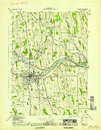 1943 Newark1943 Print · USGSWayne County's canal and rail corridor is captured here during the Second World War, showing the critical junction at Newark. Genealogists and historians can trace the Newark State School, the Abd Erie Canal, and old rural landmarks like Mud Mills or Old Houser Cem.
 - 1943 Map of Palmyra
 1943 Palmyra1943 Print · USGSWayne County comes to life in the 1940s as a hub of canal transport and religious history. Genealogists can locate family landmarks like Langdon Cem, explore the district around Hill Cumorah, or trace the old route of the (NYC) Abd Erie Canal.
End of results
Showing maps 1-2 of 2
Top cities near Newark
- Farmington historical maps
- Arcadia historical maps
- Geneva historical maps
- Canandaigua historical maps
- Canandaigua historical maps
- Ontario historical maps
See more
Frequently asked questions
- What are the different types of historical maps available for Newark?
- What is the oldest map of Newark?
- Where can I purchase historical maps of Newark for my home or office?
- Where can I download high-res historical maps of Newark?
- Are there historical topographic maps available for Newark?
- Is there historical aerial imagery available for Newark?
- Where are historical maps of Newark sourced from?