1900s (20th Century) Maps of Sodus Point, Sodus
Explore 10 historic maps of Sodus Point from the 1900s (20th Century). These maps offer a rare glimpse into what life looked like during the 1900s — showing old roads, neighborhoods, homes, and landmarks that have changed or disappeared over time.
Whether you're researching your family's past, planning a metal detecting trip, or studying how Sodus Point's landscape evolved across the 1900s, these high-resolution maps are a powerful tool for exploring the history of this region.
- Focus on a specific era: All maps on this page are from the 1900s, giving you a focused view of this time period.
- See what’s changed: Compare century-old streets, trails, and buildings to today's modern landscape using overlays and satellite layers.
- Research with precision: Use these maps for genealogy, historical research, land use analysis, or educational projects.
- View, download, or print: Maps are fully viewable online in high resolution, and can be downloaded or printed for your own records.
Start exploring Sodus Point's history through authentic maps from the 1900s. This is your window into the past.
Sodus Point, Sodus maps
(10)- 1902 Map of Sodus Bay
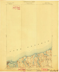 1902 Sodus Bay1902 Print · USGSThe Wayne County shoreline at the start of the twentieth century reveals a landscape of maritime navigation and glacial landforms. Trace the historic harbor at Sodus Point, locate the Big Sodus L.H., and explore the islands of Bute I. and Islay I.7 unique versions available
 - 1902 Map of Pultneyville
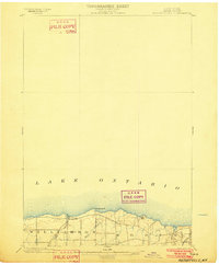 1902 Pultneyville1902 Print · USGSWayne County's lakefront comes to life in this turn-of-the-century survey of the Pultneyville harbor and surrounding orchards. Trace the early transport lines of the Electric R. R. and coastal landmarks like Fairbanks Pt. along Lake Ontario.5 unique versions available
 - 1943 Map of Sodus Point
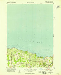
 1943 Sodus Point1943 Print · USGSWayne County's Lake Ontario shoreline is captured here during the 1940s, highlighting the area's transition from a rail-to-water shipping hub to a summer retreat. Genealogists can locate School No 13 and St Johns Fishers Chapel or trace the Pennsylvania rail line into Sodus Point.
 - 1952 Map of Salmon Creek, 1953 Print
 1952 Salmon Creek1953 Print · USGSThe Lake Ontario shoreline in Wayne County comes into focus during the early fifties, showing a rural landscape of orchards and coastal bluffs. Researchers can trace family roots at Centenary Cem or locate the old Pennsylvania rail line near Maxwell Bay.
 - 1953 Map of Sodus Point, 1955 Print
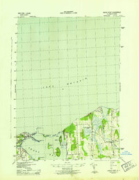
 1953 Sodus Point1955 Print · USGSThe Wayne County shoreline and the protected waters of Sodus Bay are captured here in the early fifties. Local historians can trace the rail terminus at Sodus Point, the lakeside community of Lake Bluff, and rural landmarks like St Johns Chapel.4 unique versions available
 - 1960 Map of Rochester
 1960 Rochester1960 Print · USGSThe Lake Ontario shoreline in the late fifties was a bustling corridor of rail and water commerce. Genealogists and historians can trace the path of the New York Central through canal towns like Newark or explore the coastal landmarks around Sackets Harbor.2 unique versions available
 - 1961 Map of Rochester, 1973 Print
 1961 Rochester1973 Print · USGSThe Lake Ontario shoreline and Finger Lakes frontier are shown here at the height of the mid-century infrastructure boom. Genealogists and historians can trace the rail-and-road evolution from Sackets Harbor down to the New York State Thruway, passing through centers like Pulaski and Adams Center.3 unique versions available
 - 1965 Map of Rochester
 1965 Rochester1965 Print · USGSUpstate New York's industrial heartland is captured here during a period of significant growth between the Great Lakes and the Finger Lakes. Genealogists and historians can trace the evolution of canal towns and rail hubs from Rochester to Syracuse, noting features like the Erie Canal and the New York State Thruway.
 - 1984 Map of Rochester
 1984 Rochester1984 Print · USGSThe Rochester lakefront and Genesee Valley are shown here in the mid-eighties as suburban growth reached historic canal towns and rural outposts. Genealogists can locate family landmarks like Mud Mills, the Angel Moroni Monument, and Lake View Cemetery.2 unique versions available
 - 1985 Map of Syracuse
 1985 Syracuse1985 Print · USGSCentral New York in the mid-eighties shows a landscape of established canal towns and growing metropolitan suburbs linked by rail and water. Researchers can trace the path of the Erie Canal, find the boundaries of Montezuma Marsh, and locate regional landmarks like Oneida Lake and Chimney Bluffs.3 unique versions available
End of results
Showing maps 1-10 of 10
Top cities near Sodus Point
- Arcadia historical maps
- Manchester historical maps
- Newark historical maps
- Sodus historical maps
- Palmyra historical maps
- Williamson historical maps
See more
Frequently asked questions
- What are the different types of historical maps available for Sodus Point?
- What is the oldest map of Sodus Point?
- Where can I purchase historical maps of Sodus Point for my home or office?
- Where can I download high-res historical maps of Sodus Point?
- Are there historical topographic maps available for Sodus Point?
- Is there historical aerial imagery available for Sodus Point?
- Where are historical maps of Sodus Point sourced from?