1900s (20th Century) Maps of Ashe County, North Carolina
Explore 43 historic maps of Ashe County from the 1900s (20th Century). These maps offer a rare glimpse into what life looked like during the 1900s — showing old roads, neighborhoods, homes, and landmarks that have changed or disappeared over time.
Whether you're researching your family's past, planning a metal detecting trip, or studying how Ashe County's landscape evolved across the 1900s, these high-resolution maps are a powerful tool for exploring the history of this region.
- Focus on a specific era: All maps on this page are from the 1900s, giving you a focused view of this time period.
- See what’s changed: Compare century-old streets, trails, and buildings to today's modern landscape using overlays and satellite layers.
- Research with precision: Use these maps for genealogy, historical research, land use analysis, or educational projects.
- View, download, or print: Maps are fully viewable online in high resolution, and can be downloaded or printed for your own records.
Start exploring Ashe County's history through authentic maps from the 1900s. This is your window into the past.
Ashe County, NC maps
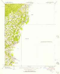
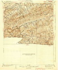
(43)- 1902 Map of Cranberry
 1902 Cranberry1902 Print · USGSThe North Carolina and Tennessee borderlands are captured here at the turn of the century as early railroads began penetrating the high ridges. Genealogists can trace family names and old settlements like Mountain City, Shoun Crossroads, and the industry at Rhea Forge.6 unique versions available
 - 1909 Map of Abingdon
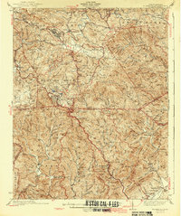
 1909 Abingdon1909 Print · USGSSouthwest Virginia at the first decade's end shows a valley landscape defined by the iron rail and steep ridges. Genealogists and historians can trace the early layouts of Abingdon and Glade Spring, or locate landmarks like Dove Mills and the County Farm.2 unique versions available
 - 1911 Map of Abingdon
 1911 Abingdon1911 Print · USGSSouthwest Virginia's rugged corridors are captured here during the height of the mountain rail era. Genealogists and historians can trace old homesteads and local landmarks such as Whites Mill, Valley Church, and the County Farm near Abingdon.5 unique versions available
 - 1935 Map of Mouth of Wilson
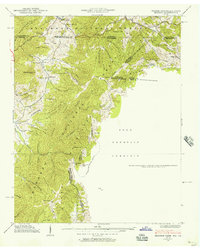
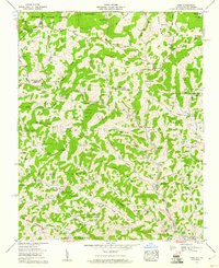
 1935 Mouth of Wilson1935 Print · USGSGrayson County was a landscape of high ridges and river crossings in the mid-1930s. Researchers can trace family sites at Youngs Chapel, find early crossings like Halsey Ferry, and locate old mountain schoolhouses like Oak Hill Sch and Fairwood Sch.
 - 1935 Map of Grayson
 1935 Grayson1935 Print · USGSThe high tri-state ridges of Washington County, Tennessee, and neighboring Virginia are shown here just before the mid-century. Genealogists and hikers can trace old mountain paths through Cut Laurel Gap, find the State Line Sch, and locate the Norfolk and Western rail line near Green Cove.
 - 1935 Map of Park
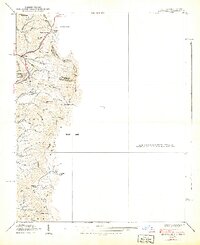
 1935 Park1935 Print · USGSThe high-country borderlands of North Carolina and Virginia appear here in the mid-1930s just as early aerial mapping began. Researchers can locate the mountain settlement of Park and trace the drainage of Green Creek through the Unaka National Forest.
 - 1935 Map of Baldwin Gap
 1935 Baldwin Gap1935 Print · USGSThe high ridges of the Tennessee and North Carolina border come into focus in the mid-1930s. Genealogists can trace early mountain life through the sites of Snyder Chapel, Curds Sch, and the isolated Wallace Cem.
 - 1935 Map of Mount Rogers
 1935 Mount Rogers1935 Print · USGSThe high peaks of Grayson and Smyth Counties are documented here in the mid-1930s as the Appalachian Trail was being established across Mount Rogers. Genealogists and historians can trace the foundations of mountain life at Konnarock, the Iron Mountain Boys Sch, and Taylors Valley.
 - 1935 Map of Zionville
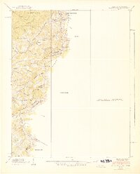
 1935 Zionville1935 Print · USGSThe Tennessee and North Carolina borderlands are captured here in the mid-1930s as high-country roads began to improve. Genealogists and hikers can trace old routes through the Gap of Rich Mtn or locate small settlements like Trade and Silverstone.
 - 1936 Map of Blowing Rock
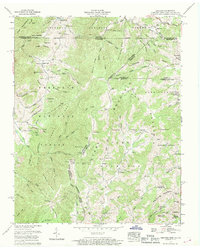
 1936 Blowing Rock1936 Print · USGSThe North Carolina high country around Boone and Blowing Rock is documented here in the mid-1930s. Genealogists and researchers can trace family-named landmarks and mountain institutions, from the COUNTY HOME to remote sites like Bailey Camp Sch and St Marys Ch.
 - 1938 Map of Baldwin Gap, 1957 Print
 1938 Baldwin Gap1957 Print · USGSThe high ridges of the Blue Ridge along the Tennessee and North Carolina border were surveyed in the late thirties. Genealogists and local historians can trace family locations near Hemlock, Wallace Cem, and rural institutions like Curd Sch and Snyder Chapel.
 - 1938 Map of Grayson, 1957 Print
 1938 Grayson1957 Print · USGSThe Appalachian high country at the junction of Tennessee, Virginia, and North Carolina comes into focus in the late 1930s. Genealogists and historians can trace rail-side life along the Norfolk and Western and locate landmarks like Waldener Grove Ch and the Sutherland Cem.
 - 1939 Map of Zionville
 1939 Zionville1939 Print · USGSThe North Carolina and Tennessee borderlands come alive in this late 1930s survey of the high mountain gaps. Genealogists can trace early homesteads near Zionville, Trade, and Greer Cem or find local landmarks like the Rich Mtn Sch.2 unique versions available
 - 1939 Map of Baldwin Gap
 1939 Baldwin Gap1939 Print · USGSThe high ridges of the Tennessee and North Carolina border come alive in this pre-war survey of the Appalachian backcountry. Genealogists can trace family footprints through numerous hollows to find Bethel Ch, Payne Cem, and the old Laurel Springs Sch.2 unique versions available
 - 1939 Map of Mount Rogers
 1939 Mount Rogers1939 Print · USGSThe Virginia and Tennessee borderlands come alive in this survey from the 1930s, showing the mountain communities and logging-era geography of the High Country. Researchers can locate the Konnarock Girls Sch, family-named mill sites like Loves Mill, and the early path of the Appalachian Trail.3 unique versions available
 - 1940 Map of Mouth of Wilson
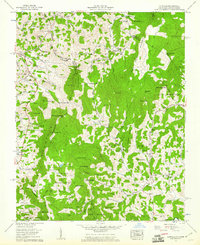
 1940 Mouth of Wilson1940 Print · USGSGrayson County's high ridges and river valleys were home to a dense network of mountain communities in the 1930s. Genealogists and historians can trace long-gone rural institutions like the COUNTY HOME, Cornell Store, and schools such as Razor Ridge Sch or Bethel Sch.3 unique versions available
 - 1942 Map of Blowing Rock
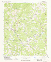
 1942 Blowing Rock1942 Print · USGSWatauga and Caldwell Counties are shown here during the late nineteen-thirties and early forties, capturing the traditional highland communities and early development of the Blue Ridge Parkway. Genealogists can locate family landmarks like Shulls Mills, Poplar Grove Ch, and Liberty Hill Sch.4 unique versions available
 - 1953 Map of Winston-Salem, 1974 Print
 1953 Winston-Salem1974 Print · USGSThe North Carolina Piedmont and Virginia highlands meet in the mid-1950s, a landscape defined by the tobacco and textile hubs of the Blue Ridge foothills. Researchers can trace the rail-and-river geography connecting Winston-Salem to mountain towns like Mount Airy and Galax.2 unique versions available
 - 1955 Map of Winston-Salem
 1955 Winston-Salem1955 Print · USGSThe Central Blue Ridge and Piedmont transition are captured here in the mid-fifties, from the industrial hub of Winston-Salem to the high peaks of Southwest Virginia. Genealogists can trace family landmarks like Richmond Hill Ch, Siloam Ch, and the old rail stops along the Southern Railway.
 - 1959 Map of Park, 1960 Print
 1959 Park1960 Print · USGSThe mountain borderlands of North Carolina and Virginia come alive in the late fifties, showing a landscape shaped by the Norfolk and Western line. Genealogists can trace family roots through dozens of local burial sites and landmarks like Nella (PO), Apple Grove Post Office, and Byars Cem.3 unique versions available
 - 1959 Map of Zionville, 1961 Print
 1959 Zionville1961 Print · USGSThe borderlands of North Carolina and Tennessee come alive in the late fifties, showing a landscape of high peaks and isolated creek-side settlements. Genealogists can trace old family roots at Winbarger Mill, Pottertown (Tamarack PO), and the Maine Cem.4 unique versions available
 - 1959 Map of Baldwin Gap, 1961 Print
 1959 Baldwin Gap1961 Print · USGSThe high borderlands of the Tennessee-North Carolina line come alive in the late fifties, following the high ridges of Stone Mountain. Genealogists and local historians can trace family burial sites like Graybeal Cem and McEwen Cem or locate the rural Forge Sch.4 unique versions available
 - 1959 Map of Grayson, 1969 Print
 1959 Grayson1969 Print · USGSIn the late 1950s, the mountain borders of Tennessee, Virginia, and North Carolina remained a patchwork of isolated family farmsteads and timbered ridges. Researchers can trace the Norfolk and Western rail corridor and find dozens of small family plots like Rye Cove Cem and Taylor Cem.3 unique versions available
 - 1962 Map of Winston-Salem
 1962 Winston-Salem1962 Print · USGSThe North Carolina Piedmont meets the Virginia highlands in the early sixties, showing the rail corridors and mountain gaps of the southern Appalachians. Researchers can trace the Blue Ridge Parkway or locate family sites near Winston-Salem, Mount Airy, and Hanging Rock Mountain.
 - 1966 Map of Todd, 1968 Print
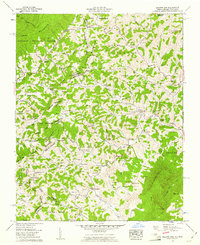
 1966 Todd1968 Print · USGSAshe and Watauga counties are shown here in the mid-1960s, centered on the river-bend communities along the South Fork New River. Researchers can trace family sites near Todd, locate remote country churches like Bethany Ch, or follow the path of Railroad Grade Road.2 unique versions available
Showing maps 1-25 of 43
Top cities of Ashe County
Frequently asked questions
- What are the different types of historical maps available for Ashe County?
- What is the oldest map of Ashe County?
- Where can I purchase historical maps of Ashe County for my home or office?
- Where can I download high-res historical maps of Ashe County?
- Are there historical topographic maps available for Ashe County?
- Is there historical aerial imagery available for Ashe County?
- Where are historical maps of Ashe County sourced from?