1960s Maps of Ashe County, North Carolina
Explore 13 historic maps of Ashe County from the 1960s. These maps offer a rare glimpse into what life looked like during the 1960s — showing old roads, neighborhoods, homes, and landmarks that have changed or disappeared over time.
Whether you're researching your family's past, planning a metal detecting trip, or studying how Ashe County's landscape evolved across the 1960s, these high-resolution maps are a powerful tool for exploring the history of this region.
- Focus on a specific era: All maps on this page are from the 1960s, giving you a focused view of this time period.
- See what’s changed: Compare century-old streets, trails, and buildings to today's modern landscape using overlays and satellite layers.
- Research with precision: Use these maps for genealogy, historical research, land use analysis, or educational projects.
- View, download, or print: Maps are fully viewable online in high resolution, and can be downloaded or printed for your own records.
Start exploring Ashe County's history through authentic maps from the 1960s. This is your window into the past.
Ashe County, NC maps
(13)- 1962 Map of Winston-Salem
 1962 Winston-Salem1962 Print · USGSThe North Carolina Piedmont meets the Virginia highlands in the early sixties, showing the rail corridors and mountain gaps of the southern Appalachians. Researchers can trace the Blue Ridge Parkway or locate family sites near Winston-Salem, Mount Airy, and Hanging Rock Mountain.
 - 1966 Map of Todd, 1968 Print
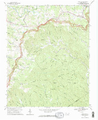
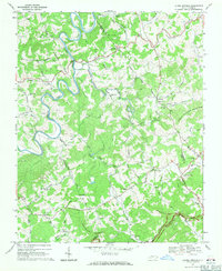
 1966 Todd1968 Print · USGSAshe and Watauga counties are shown here in the mid-1960s, centered on the river-bend communities along the South Fork New River. Researchers can trace family sites near Todd, locate remote country churches like Bethany Ch, or follow the path of Railroad Grade Road.2 unique versions available
 - 1966 Map of Mouth of Wilson, 1968 Print
 1966 Mouth of Wilson1968 Print · USGSThe borderlands of Virginia and North Carolina appear in the mid-1960s as a landscape of river bends and high knobs. Genealogists can trace family footprints across Chestnut Hill and Piney Creek, locating landmarks like Weavers Ford and Youngs Chapel.3 unique versions available
 - 1966 Map of Maple Springs, 1968 Print
 1966 Maple Springs1968 Print · USGSWilkes and Watauga counties in the mid-sixties are shown as a network of ridge-top overlooks and creek-bed communities. Researchers can trace family history through local landmarks like Mt Zion, Yellow Hill Ch, and the many cemeteries dotted along the Blue Ridge Parkway.2 unique versions available
 - 1966 Map of Grassy Creek, 1968 Print
 1966 Grassy Creek1968 Print · USGSThe North Carolina and Virginia state line bisects these Blue Ridge highlands in the mid-sixties, where the river bends around Walnut Hill. Genealogists can trace family landmarks like the Va-NC Sch, Greenwood Cem, and the community at Crumpler.2 unique versions available
 - 1966 Map of Warrensville, 1969 Print
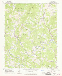
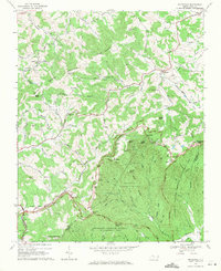
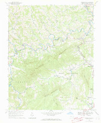 1966 Warrensville1969 Print · USGSAshe County high country in the mid-1960s was a landscape of steep ridges and river-valley hamlets. Genealogists can trace family sites from Milam Cem to Ashley Chapel, or follow the Norfolk and Western Railway through Lansing and Warrensville.3 unique versions available
 - 1967 Map of Glendale Springs, 1968 Print
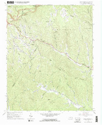
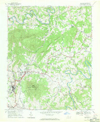
 1967 Glendale Springs1968 Print · USGSAshe and Wilkes counties are shown here in the late sixties as the high country transitioned into a modern mountain community. Genealogists can trace family names and small congregations at Holy Trinity Ch, Othello, and Henson Cem.3 unique versions available
 - 1967 Map of Deep Gap, 1969 Print
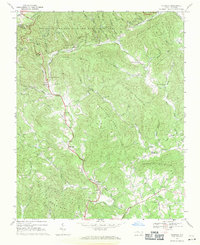
 1967 Deep Gap1969 Print · USGSThe Watauga County highlands in the late sixties are defined by the winding Blue Ridge Parkway and high-elevation settlements. Genealogists and historians can locate old mountain churches and schools like Fairview Ch, Parkway Sch, and Mt Paran Ch.2 unique versions available
 - 1968 Map of Jefferson, 1971 Print
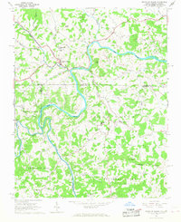
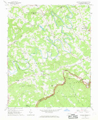
 1968 Jefferson1971 Print · USGSThe twin mountain towns of Jefferson and West Jefferson are shown in detail during the late 1960s. Researchers can locate family landmarks like Ashe Central Sch, Shatley Springs, and Friendship Ch among the river forks.
 - 1968 Map of Laurel Springs, 1971 Print
 1968 Laurel Springs1971 Print · USGSAshe and Alleghany Counties in the late sixties remain deeply rooted in the high country, where the South Fork New River winds through the hills. Genealogists and local historians can trace family locations near landmarks like Liberty Hill Ch, Laurel Springs Sch, and Peach Bottom Mountain.2 unique versions available
 - 1968 Map of Whitehead, 1971 Print
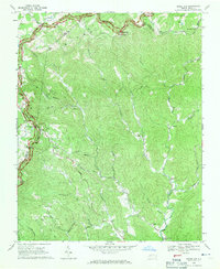
 1968 Whitehead1971 Print · USGSAlleghany County high country is shown here in the late sixties as the mountain landscape transitioned toward conservation and recreation. Genealogists and hikers can trace old homesites and mountain churches like Antioch Ch or explore the preserved Brinegar Cabin and Caudill Cabin.
 - 1968 Map of Mc Grady, 1971 Print
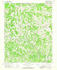
 1968 Mc Grady1971 Print · USGSThe Blue Ridge foothills of Wilkes County come into focus during the late sixties, showing a landscape of steep ridges and creek-side settlements. Genealogists can trace family roots through numerous sites like Halls Mills, Rock Springs Ch, and the Cane Creek Ch Cem.2 unique versions available
 - 1968 Map of Horse Gap, 1971 Print
 1968 Horse Gap1971 Print · USGSWilkes and Ashe counties are captured here in the late sixties, showing a landscape of high ridges and deep mountain branches. Genealogists can locate family landmarks such as Antioch Church, Old Union Church, and the Union Township School.2 unique versions available
End of results
Showing maps 1-13 of 13
Top cities of Ashe County
Frequently asked questions
- What are the different types of historical maps available for Ashe County?
- What is the oldest map of Ashe County?
- Where can I purchase historical maps of Ashe County for my home or office?
- Where can I download high-res historical maps of Ashe County?
- Are there historical topographic maps available for Ashe County?
- Is there historical aerial imagery available for Ashe County?
- Where are historical maps of Ashe County sourced from?