1990s Maps of Ashe County, North Carolina
Explore 5 historic maps of Ashe County from the 1990s. These maps offer a rare glimpse into what life looked like during the 1990s — showing old roads, neighborhoods, homes, and landmarks that have changed or disappeared over time.
Whether you're researching your family's past, planning a metal detecting trip, or studying how Ashe County's landscape evolved across the 1990s, these high-resolution maps are a powerful tool for exploring the history of this region.
- Focus on a specific era: All maps on this page are from the 1990s, giving you a focused view of this time period.
- See what’s changed: Compare century-old streets, trails, and buildings to today's modern landscape using overlays and satellite layers.
- Research with precision: Use these maps for genealogy, historical research, land use analysis, or educational projects.
- View, download, or print: Maps are fully viewable online in high resolution, and can be downloaded or printed for your own records.
Start exploring Ashe County's history through authentic maps from the 1990s. This is your window into the past.
Ashe County, NC maps
(5)- 1996 Map of Laurel Springs, 1999 Print
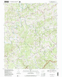 1996 Laurel Springs1999 Print · USGSThe high ridges of Ashe and Alleghany counties are shown here in the late twentieth century, centered on the winding South Fork New River. Researchers can trace rural lineages through numerous community landmarks like Laurel Springs Sch and Ebenezer Ch.
 - 1998 Map of Deep Gap, 1999 Print
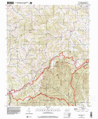
 1998 Deep Gap1999 Print · USGSThe Blue Ridge highlands in the late 1990s are mapped here as the Blue Ridge Parkway snakes through Watauga and Wilkes counties. Researchers can locate remote mountain communities like Triplett, Laxon, and Rutherwood, alongside landmarks such as Holy Trinity Chapel and Parkway Sch.
 - 1998 Map of Jefferson, 1999 Print
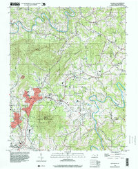 1998 Jefferson1999 Print · USGSAshe County's mountainous landscape appears in detail during the late nineties, centered on the growth of Jefferson and West Jefferson. Researchers can trace rural lineages through local landmarks like Shatley Springs, Friendship Ch, and the Ashe Central Sch.
 - 1998 Map of Whitehead, 1999 Print
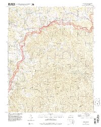
 1998 Whitehead1999 Print · USGSNorth Carolina's high ridges and river valleys are captured here in the late nineties as the Blue Ridge Parkway winds through ALLEGHANY CO. Genealogists and local historians can trace family-named sites like Brinegar Cabin, Antioch Cem, and Piney Fork Ch.
 - 1998 Map of Todd, 1999 Print
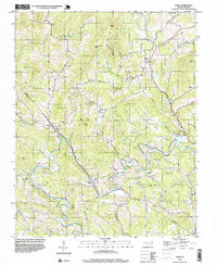 1998 Todd1999 Print · USGSAshe and Watauga counties are captured here in the late 1990s as the river-valley communities maintained their rural character. Genealogists can trace family roots through the many rural cemeteries and landmarks like Elkland Sch, Bethany Ch, and the settlement of Todd.
End of results
Showing maps 1-5 of 5
Top cities of Ashe County
Frequently asked questions
- What are the different types of historical maps available for Ashe County?
- What is the oldest map of Ashe County?
- Where can I purchase historical maps of Ashe County for my home or office?
- Where can I download high-res historical maps of Ashe County?
- Are there historical topographic maps available for Ashe County?
- Is there historical aerial imagery available for Ashe County?
- Where are historical maps of Ashe County sourced from?