1900-1909 Maps of Bertie County, North Carolina
Explore 3 historic maps of Bertie County from 1900-1909. These maps offer a rare glimpse into what life looked like during the 1900s — showing old roads, neighborhoods, homes, and landmarks that have changed or disappeared over time.
Whether you're researching your family's past, planning a metal detecting trip, or studying how Bertie County's landscape evolved across the 1900s, these high-resolution maps are a powerful tool for exploring the history of this region.
- Focus on a specific era: All maps on this page are from the 1900s, giving you a focused view of this time period.
- See what’s changed: Compare century-old streets, trails, and buildings to today's modern landscape using overlays and satellite layers.
- Research with precision: Use these maps for genealogy, historical research, land use analysis, or educational projects.
- View, download, or print: Maps are fully viewable online in high resolution, and can be downloaded or printed for your own records.
Start exploring Bertie County's history through authentic maps from the 1900s. This is your window into the past.
Bertie County, NC maps
(3)- 1901 Map of Williamston, 1972 Print
 1901 Williamston1972 Print · USGSThe Roanoke River basin at the turn of the century shows a thriving network of steamboat landings and new rail lines. Genealogists and researchers can trace the river economy through Spellers Ferry Landing, Grabtown, and the Atlantic Coast Line R. R.
 - 1902 Map of Williamston, 1944 Print
 1902 Williamston1944 Print · USGSMartin County’s riverfront and rail corridors are frozen in time here at the dawn of the twentieth century. Genealogists and local historians can trace family roots through landings like Spellers Ferry Landing or settlements at Everetts and Goldpoint.
 - 1904 Map of Edenton
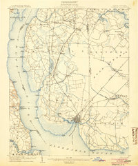 1904 Edenton1904 Print · USGSThe Chowan River and Albemarle Sound waterfronts are documented here at the turn of the century. Genealogists and historians can trace defunct river landings like Jernigens Wharf and old postal hubs such as Mege P.O. and Tynes P.O. Center Hill.2 unique versions available
End of results
Showing maps 1-3 of 3
Top cities of Bertie County
- Windsor historical maps
- Aulander historical maps
- Lewiston Woodville historical maps
- Roxobel historical maps
- Powellsville historical maps
- Askewville historical maps
See more
Frequently asked questions
- What are the different types of historical maps available for Bertie County?
- What is the oldest map of Bertie County?
- Where can I purchase historical maps of Bertie County for my home or office?
- Where can I download high-res historical maps of Bertie County?
- Are there historical topographic maps available for Bertie County?
- Is there historical aerial imagery available for Bertie County?
- Where are historical maps of Bertie County sourced from?