1940s Maps of Oak Island, North Carolina
Explore 4 historic maps of Oak Island from the 1940s. These maps offer a rare glimpse into what life looked like during the 1940s — showing old roads, neighborhoods, homes, and landmarks that have changed or disappeared over time.
Whether you're researching your family's past, planning a metal detecting trip, or studying how Oak Island's landscape evolved across the 1940s, these high-resolution maps are a powerful tool for exploring the history of this region.
- Focus on a specific era: All maps on this page are from the 1940s, giving you a focused view of this time period.
- See what’s changed: Compare century-old streets, trails, and buildings to today's modern landscape using overlays and satellite layers.
- Research with precision: Use these maps for genealogy, historical research, land use analysis, or educational projects.
- View, download, or print: Maps are fully viewable online in high resolution, and can be downloaded or printed for your own records.
Start exploring Oak Island's history through authentic maps from the 1940s. This is your window into the past.
Oak Island, NC maps
(4)- 1943 Map of Lockwoods Folly, 1962 Print
 1943 Lockwoods Folly1962 Print · USGSCoastal Brunswick County is shown here during the early 1940s, when the shoreline was defined by quiet landings and maritime forest. Genealogists and historians can trace family-named landmarks and old settlements like Varnum Town, Dixon Chapel, and Holden Beach.
 - 1944 Map of Lockwoods Folly
 1944 Lockwoods Folly1944 Print · USGSThe Brunswick County coast during the 1940s reveals a landscape of tidal marshes and quiet river landings before the era of modern development. Trace the maritime history of Varnum Town and follow family-named landmarks like Gores Ldg and the uniquely named Half Hell Road.
 - 1946 Map of Southport
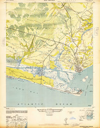 1946 Southport1946 Print · USGSImmediately following the war, this coastal area shows the intersection of maritime defense and river-based commerce. Researchers can trace family landmarks and civic sites like the Brunswick Co Home, Browns Ch, and the grounds of Fort Caswell.
 - 1949 Map of Georgetown, 1953 Print
 1949 Georgetown1953 Print · USGSThe South Carolina coast and North Carolina borderlands appear here in the mid-century, prior to the major modern development of the Grand Strand. Genealogists and historians can trace the rail networks of the Seaboard Air Line Railroad and locate coastal landmarks from Fort Caswell to McClellanville.
End of results
Showing maps 1-4 of 4
Top cities near Oak Island
- Boiling Spring Lakes historical maps
- Southport historical maps
- Shallotte historical maps
- Holden Beach historical maps
- Varnamtown historical maps
- Caswell Beach historical maps
See more
Top neighborhoods of Oak Island
Frequently asked questions
- What are the different types of historical maps available for Oak Island?
- What is the oldest map of Oak Island?
- Where can I purchase historical maps of Oak Island for my home or office?
- Where can I download high-res historical maps of Oak Island?
- Are there historical topographic maps available for Oak Island?
- Is there historical aerial imagery available for Oak Island?
- Where are historical maps of Oak Island sourced from?