1980s Maps of Oak Island, North Carolina
Explore 3 historic maps of Oak Island from the 1980s. These maps offer a rare glimpse into what life looked like during the 1980s — showing old roads, neighborhoods, homes, and landmarks that have changed or disappeared over time.
Whether you're researching your family's past, planning a metal detecting trip, or studying how Oak Island's landscape evolved across the 1980s, these high-resolution maps are a powerful tool for exploring the history of this region.
- Focus on a specific era: All maps on this page are from the 1980s, giving you a focused view of this time period.
- See what’s changed: Compare century-old streets, trails, and buildings to today's modern landscape using overlays and satellite layers.
- Research with precision: Use these maps for genealogy, historical research, land use analysis, or educational projects.
- View, download, or print: Maps are fully viewable online in high resolution, and can be downloaded or printed for your own records.
Start exploring Oak Island's history through authentic maps from the 1980s. This is your window into the past.
Oak Island, NC maps
(3)- 1980 Map of Lockwoods Folly, 1985 Print
 1980 Lockwoods Folly1985 Print · USGSCoastal Brunswick County comes into focus in this early 1980s aerial survey, revealing the intersection of timberland, swamp, and sea. Genealogists and historians can trace the rural layouts of Varnum Town and Lennon Crossroads along the banks of the Lockwoods Folly River.
 - 1980 Map of Southport, 1985 Print
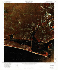 1980 Southport1985 Print · USGSThe Brunswick County coast comes into focus in the early eighties, showing the transition from historic river ports to growing beach communities. Genealogists and historians can trace the foundations of Yaupon Beach, the fortifications at Fort Caswell, and the waterfront at Southport.
 - 1986 Map of Myrtle Beach
 1986 Myrtle Beach1986 Print · USGSThe Grand Strand and Brunswick County coast are captured in the mid-eighties before the late-century development boom. Researchers can trace the footprint of the Myrtle Beach Air Force Base and old coastal settlements like Atlantic Beach and Socastee.
End of results
Showing maps 1-3 of 3
Top cities near Oak Island
- Boiling Spring Lakes historical maps
- Southport historical maps
- Shallotte historical maps
- Holden Beach historical maps
- Varnamtown historical maps
- Caswell Beach historical maps
See more
Top neighborhoods of Oak Island
Frequently asked questions
- What are the different types of historical maps available for Oak Island?
- What is the oldest map of Oak Island?
- Where can I purchase historical maps of Oak Island for my home or office?
- Where can I download high-res historical maps of Oak Island?
- Are there historical topographic maps available for Oak Island?
- Is there historical aerial imagery available for Oak Island?
- Where are historical maps of Oak Island sourced from?