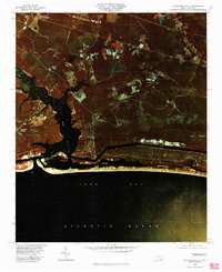
1980 Map of Lockwoods Folly
USGS Topo · Published 1985About this map
Varnum Town and the coastal crossroads of Brunswick County are captured in this color infrared aerial study, which highlights the delicate boundary between the dark waters of the Lockwoods Folly River and the cultivated lands of the interior. The imagery reveals the intricate drainage patterns of the coastal plain, from the winding course of Mill Creek to the broad reach of Ash Swamp. Along the southern edge, the barrier landforms separating Montgomery Slough from the Atlantic Ocean show early residential development patterns emerging near Long Bay. This orthophoto provides a unique perspective on the rural character of communities like Lennon Crossroads, Sandy Hill, and Midway, showing how forest, farm, and wetland dictated the placement of homes and roads before the era of intensive coastal expansion.
Find a feature on this map
10 named features on this map. Tap any name to fly to it.
Don’t see what you’re looking for? This feature index may not catch every label — zoom into the map to look around manually.
Map Details
Editions of this 1980 Lockwoods Folly Map
This is the sole edition of this map. No revisions or reprints were ever made.
Other maps of this area

1943 · Funston
USGS Topo · 1:24,000

1943 · Holden Beach
USGS Topo · 1:24,000

1943 · Bolivia
USGS Topo · 1:24,000

1943 · Lockwoods Folly
USGS Topo · 1:24,000

1943 · Supply
USGS Topo · 1:24,000

1944 · Supply
USGS Topo · 1:31,680

1944 · Bolivia
USGS Topo · 1:31,680

1944 · Lockwoods Folly
USGS Topo · 1:31,680

1946 · Southport
USGS Topo · 1:24,000

1949 · Georgetown
USGS Topo · 1:250,000