
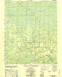
1944 Map of Lockwoods Folly
USGS Topo · Published 1944About this map
The Lockwoods Folly River dominates this coastal landscape, winding through the tidal marshes of Brunswick County to meet the Atlantic at the Lockwoods Folly Inlet. This mid-century survey reveals a network of water-dependent landings and small settlements like Varnum Town and Lennon Crossroads. The maritime character of the region is evident in the path of the Intracoastal Waterway, which cuts across the marshland north of Sheep Island and Holden Beach.
Find a feature on this map
32 named features on this map. Tap any name to fly to it.
Don’t see what you’re looking for? This feature index may not catch every label — zoom into the map to look around manually.
Map Details
Editions of this 1944 Lockwoods Folly Map
This is the sole edition of this map. No revisions or reprints were ever made.
Other maps of this area

1943 · Funston
USGS Topo · 1:24,000

1943 · Holden Beach
USGS Topo · 1:24,000

1943 · Bolivia
USGS Topo · 1:24,000

1943 · Lockwoods Folly
USGS Topo · 1:24,000

1943 · Supply
USGS Topo · 1:24,000

1944 · Supply
USGS Topo · 1:31,680

1944 · Bolivia
USGS Topo · 1:31,680

1946 · Southport
USGS Topo · 1:24,000

1949 · Georgetown
USGS Topo · 1:250,000
1950 · Supply
USGS Topo · 1:25,000