1960s Maps of Buncombe County, North Carolina
Explore 12 historic maps of Buncombe County from the 1960s. These maps offer a rare glimpse into what life looked like during the 1960s — showing old roads, neighborhoods, homes, and landmarks that have changed or disappeared over time.
Whether you're researching your family's past, planning a metal detecting trip, or studying how Buncombe County's landscape evolved across the 1960s, these high-resolution maps are a powerful tool for exploring the history of this region.
- Focus on a specific era: All maps on this page are from the 1960s, giving you a focused view of this time period.
- See what’s changed: Compare century-old streets, trails, and buildings to today's modern landscape using overlays and satellite layers.
- Research with precision: Use these maps for genealogy, historical research, land use analysis, or educational projects.
- View, download, or print: Maps are fully viewable online in high resolution, and can be downloaded or printed for your own records.
Start exploring Buncombe County's history through authentic maps from the 1960s. This is your window into the past.
Buncombe County, NC maps
(12)- 1960 Map of Knoxville
 1960 Knoxville1960 Print · USGSThe Southern Appalachians come alive in the 1950s, showing the intersection of new national park tourism and deep-rooted mountain industry. Trace old rail lines like the Clinchfield RR and find high-altitude landmarks from Mt Le Conte to the Cherokee Indian Reservation.2 unique versions available
 - 1961 Map of Asheville, 1965 Print
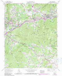
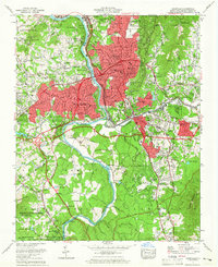 1961 Asheville1965 Print · USGSAsheville and the French Broad River valley are captured here in the early sixties, showing a landscape balanced between mountain forest and urban expansion. Trace local history through Biltmore Forest, Sayles Village, and the Blue Ridge Parkway.3 unique versions available
 - 1961 Map of Enka, 1965 Print
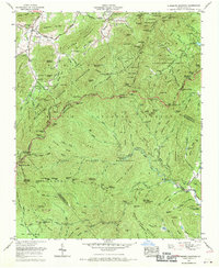
 1961 Enka1965 Print · USGSWestern Buncombe County appears in the early sixties as a mix of industrial activity and mountain settlements. Genealogists can trace family names across Starnes Ridge and find local landmarks like Enka Village and Zion Hill Ch.4 unique versions available
 - 1962 Map of Marion, 1964 Print
 1962 Marion1964 Print · USGSMcDowell County life in the early sixties centers on the rail junction at Marion and the rising peaks of the Blue Ridge. Genealogists and historians can trace community roots through Carson Chapel, Zion Hill Cem, and the old Pleasant Gardens School.2 unique versions available
 - 1962 Map of Weaverville, 1965 Print
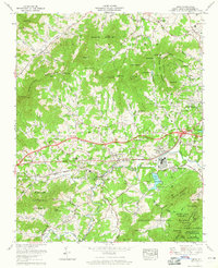
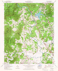
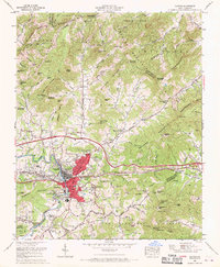
 1962 Weaverville1965 Print · USGSBuncombe County underwent significant development in the early sixties as the suburbs of Asheville pushed north toward Weaverville. Local researchers can trace family roots through sites like Coles Cem, find the Asheville-Weaverville Speedway, and locate the historic Craggy Prison near the river.3 unique versions available
 - 1962 Map of Oteen, 1990 Print
 1962 Oteen1990 Print · USGSThe Swannanoa River valley and its mountain surrounds show a mid-century landscape of growing institutions and rural traditions. Researchers can trace historic sites like Warren Wilson College, the Cane Creek Cem, and Camp Blackfoot.2 unique versions available
 - 1964 Map of Knoxville
 1964 Knoxville1964 Print · USGSThe Southern Appalachians and Great Smokies are captured here during the mid-sixties, showing the rugged borderlands of Tennessee and North Carolina. Researchers can trace historic mountain routes like U S 441, the expanse of Pisgah National Forest, and the growing footprints of Asheville and Knoxville.
 - 1965 Map of Skyland, 1966 Print
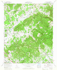
 1965 Skyland1966 Print · USGSThe French Broad River valley south of Asheville is shown here in the mid-sixties as regional infrastructure began to modernize the mountain landscape. Genealogists and local historians can trace the Southern rail corridor through Skyland or locate family sites like Oak Forest Cem and Fanning Chapel.6 unique versions available
 - 1965 Map of Fruitland, 1966 Print
 1965 Fruitland1966 Print · USGSNorth Carolina’s mountain ridges and valley settlements are caught here in the mid-sixties as the region balanced its rural roots with new development. Researchers can locate family landmarks like the Pittillo-Lanning Cemetery or trace the grounds of the Fruitland Bible Institute and Christ School.4 unique versions available
 - 1967 Map of Fines Creek, 1970 Print
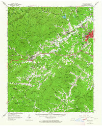
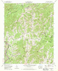 1967 Fines Creek1970 Print · USGSThe mountain coves of Haywood and Madison counties are captured here in the late sixties, showcasing the deeply rooted communities of the Blue Ridge. Researchers can locate numerous family burial sites and country churches, including Belmont Ch Cem, James Chapel, and Fines Cem.3 unique versions available
 - 1967 Map of Dunsmore Mountain, 1970 Print
 1967 Dunsmore Mountain1970 Print · USGSThe high ridges of the Pisgah mountains appear in the late 1960s as a complex network of forest experimental grounds and wildlife management areas. Genealogists and hikers can trace the Blue Ridge Parkway past Mt Pisgah Church and the Kelley Cem.3 unique versions available
 - 1967 Map of Canton, 1970 Print
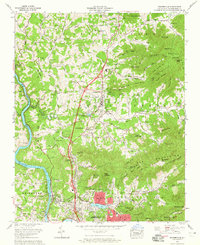
 1967 Canton1970 Print · USGSCanton and the surrounding Haywood County highlands are shown here in the late sixties as modern interstate travel began to reshape the valley. Genealogists can trace family names and local landmarks through sites like Henderson Cemetery, Fibreville, and Pisgah High School.4 unique versions available
End of results
Showing maps 1-12 of 12
Top cities of Buncombe County
- Asheville historical maps
- Black Mountain historical maps
- Swannanoa historical maps
- Woodfin historical maps
- Weaverville historical maps
- Biltmore Forest historical maps
See more
Frequently asked questions
- What are the different types of historical maps available for Buncombe County?
- What is the oldest map of Buncombe County?
- Where can I purchase historical maps of Buncombe County for my home or office?
- Where can I download high-res historical maps of Buncombe County?
- Are there historical topographic maps available for Buncombe County?
- Is there historical aerial imagery available for Buncombe County?
- Where are historical maps of Buncombe County sourced from?