1980s Maps of Buncombe County, North Carolina
Explore 4 historic maps of Buncombe County from the 1980s. These maps offer a rare glimpse into what life looked like during the 1980s — showing old roads, neighborhoods, homes, and landmarks that have changed or disappeared over time.
Whether you're researching your family's past, planning a metal detecting trip, or studying how Buncombe County's landscape evolved across the 1980s, these high-resolution maps are a powerful tool for exploring the history of this region.
- Focus on a specific era: All maps on this page are from the 1980s, giving you a focused view of this time period.
- See what’s changed: Compare century-old streets, trails, and buildings to today's modern landscape using overlays and satellite layers.
- Research with precision: Use these maps for genealogy, historical research, land use analysis, or educational projects.
- View, download, or print: Maps are fully viewable online in high resolution, and can be downloaded or printed for your own records.
Start exploring Buncombe County's history through authentic maps from the 1980s. This is your window into the past.
Buncombe County, NC maps
(4)- 1982 Map of Lake Lure, 1983 Print
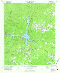 1982 Lake Lure1983 Print · USGSThe Hickory Nut Gorge area near the start of the 1980s reveals a landscape of high peaks and deep waters centered on Lake Lure. Genealogists and historians can locate rural landmarks like St Johns Ch, Cooper Gap Ch, and the small settlement at Uree.3 unique versions available
 - 1982 Map of Moffitt Hill, 1983 Print
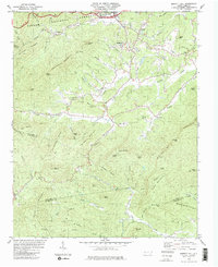 1982 Moffitt Hill1983 Print · USGSThe McDowell and Buncombe county lines meet among the steep ridges of the Pisgah National Forest in the early 1980s. Genealogists can trace family names and rural landmarks from Old Fort down to Bethlehem Ch and the remote Pine Cove Cem.2 unique versions available
 - 1985 Map of Asheville
 1985 Asheville1985 Print · USGSWestern North Carolina during the mid-eighties shows a region of deep mountain heritage and expanding highway networks. Genealogists and historians can trace the foundations of Asheville alongside older rail corridors like the Clinchfield Railroad and the high elevations of Mount Mitchell.2 unique versions available
 - 1986 Map of Hendersonville
 1986 Hendersonville1986 Print · USGSThe Blue Ridge foothills of North and South Carolina are documented here in the mid-eighties as modern highways began to reshape mountain travel. Local historians can trace the paths of the Southern Railway through Hendersonville or locate landmarks like Looking Glass Rock and Inman Mills.2 unique versions available
End of results
Showing maps 1-4 of 4
Top cities of Buncombe County
- Asheville historical maps
- Black Mountain historical maps
- Swannanoa historical maps
- Woodfin historical maps
- Weaverville historical maps
- Biltmore Forest historical maps
See more
Frequently asked questions
- What are the different types of historical maps available for Buncombe County?
- What is the oldest map of Buncombe County?
- Where can I purchase historical maps of Buncombe County for my home or office?
- Where can I download high-res historical maps of Buncombe County?
- Are there historical topographic maps available for Buncombe County?
- Is there historical aerial imagery available for Buncombe County?
- Where are historical maps of Buncombe County sourced from?