1990s Maps of Buncombe County, North Carolina
Explore 12 historic maps of Buncombe County from the 1990s. These maps offer a rare glimpse into what life looked like during the 1990s — showing old roads, neighborhoods, homes, and landmarks that have changed or disappeared over time.
Whether you're researching your family's past, planning a metal detecting trip, or studying how Buncombe County's landscape evolved across the 1990s, these high-resolution maps are a powerful tool for exploring the history of this region.
- Focus on a specific era: All maps on this page are from the 1990s, giving you a focused view of this time period.
- See what’s changed: Compare century-old streets, trails, and buildings to today's modern landscape using overlays and satellite layers.
- Research with precision: Use these maps for genealogy, historical research, land use analysis, or educational projects.
- View, download, or print: Maps are fully viewable online in high resolution, and can be downloaded or printed for your own records.
Start exploring Buncombe County's history through authentic maps from the 1990s. This is your window into the past.
Buncombe County, NC maps
(12)- 1994 Map of Montreat, 1998 Print
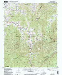
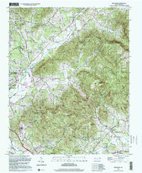
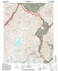 1994 Montreat1998 Print · USGSHigh peaks and protected watersheds dominate the Buncombe County landscape in the 1990s as the Blue Ridge Parkway skirts the eastern ridges. Researchers can trace the grounds of Black Mountain College or locate the Graphite Mine and Homers Chapel in the valleys below.
 - 1994 Map of Black Mountain, 1998 Print
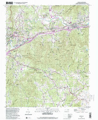
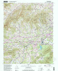
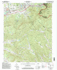 1994 Black Mountain1998 Print · USGSBuncombe and McDowell counties appear in the mid-1990s as a high-altitude crossroads for the railway and Interstate 40. Researchers can trace the legacy of local institutions like the Mountain Orphanage and find family landmarks such as Wilkes Church or the Swannanoa Tunnel.
 - 1994 Map of Moffitt Hill, 1998 Print
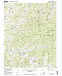
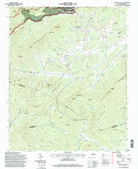 1994 Moffitt Hill1998 Print · USGSThe Blue Ridge foothills of McDowell County are shown in the mid-nineties as a network of mountain communities and forest lands. Genealogists and hikers can trace old family sites and mountain routes near Old Fort, Lackey Town, and Catawba Falls.
 - 1997 Map of Weaverville, 2001 Print
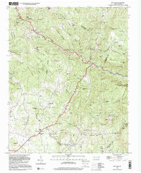
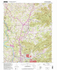 1997 Weaverville2001 Print · USGSBuncombe County's transition from rural mountain coves to suburban corridors is captured here during the late nineties. Genealogists and local historians can trace family-named sites like Whitted Knob and Garrison Cem, or locate landmarks such as the Asheville Weaverville Speedway and Craggy Prison.
 - 1997 Map of Cruso, 2001 Print
 1997 Cruso2001 Print · USGSThe East Fork of the Pigeon River valley in the late 1990s remained a landscape of tight-knit mountain coves and significant wilderness peaks. Researchers can trace family history through sites like Longs Chapel, Gudger Cem, and Burnett Cove Ch located beneath the shadows of Cold Mountain.
 - 1997 Map of Oteen, 2001 Print
 1997 Oteen2001 Print · USGSBuncombe County's mountain-and-valley landscape is documented here during the late twentieth century, showing the growth of communities east of Asheville. Researchers can locate family landmarks such as Warren Wilson College, Bethel Ch, and the Asheville Recreation Park.
 - 1997 Map of Bat Cave, 2001 Print
 1997 Bat Cave2001 Print · USGSHenderson County's mountain passes and river gaps are captured here in the late twentieth century, showing the enduring rural layout of the Blue Ridge. Genealogists and hikers can trace family sites like Edneyville Cem or locate historical landmarks including Maxwell Mill and the Bat Caves.
 - 1997 Map of Dunsmore Mountain, 2001 Print
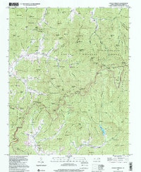
 1997 Dunsmore Mountain2001 Print · USGSThe high ridges and deep gaps of the Blue Ridge south of Asheville are shown here in the late twentieth century. Genealogists and hikers can trace old mountain congregations at Mt Pisgah Church or find historic burial sites like Stony Fork Cem and Stuart Cem.
 - 1997 Map of Craggy Pinnacle, 2001 Print
 1997 Craggy Pinnacle2001 Print · USGSThe high peaks of the Blue Ridge Mountains are documented here in the late twentieth century, showing the rugged interface of national forest land and remote settlements. Researchers can trace family sites like Ballard Cem, local landmarks like Rattlesnake Lodge, and the early development of Riceville.
 - 1997 Map of Fruitland, 2001 Print
 1997 Fruitland2001 Print · USGSThe mountain valleys of Henderson and Buncombe counties come into focus in this late-twentieth-century survey. Genealogists and local historians can trace family landmarks like Pittillo-Lanning Cem and the Fruitland Bible Institute.
 - 1998 Map of Enka, 2001 Print
 1998 Enka2001 Print · USGSBuncombe County at the close of the twentieth century shows a blend of mountain wilderness and growing industrial settlements. Genealogists can trace family sites at Forest Lawn Cem and Hice Hill Cem or locate community hubs like Enka Village and Justice.
 - 1998 Map of Barnardsville, 2001 Print
 1998 Barnardsville2001 Print · USGSBarnardsville and the surrounding Blue Ridge hollows are shown here at the turn of the 21st century. Genealogists can locate family names at Big Ivy Cem or Whitaker Cem and trace the old settlements of Dillingham and Democrat.
End of results
Showing maps 1-12 of 12
Top cities of Buncombe County
- Asheville historical maps
- Black Mountain historical maps
- Swannanoa historical maps
- Woodfin historical maps
- Weaverville historical maps
- Biltmore Forest historical maps
See more
Frequently asked questions
- What are the different types of historical maps available for Buncombe County?
- What is the oldest map of Buncombe County?
- Where can I purchase historical maps of Buncombe County for my home or office?
- Where can I download high-res historical maps of Buncombe County?
- Are there historical topographic maps available for Buncombe County?
- Is there historical aerial imagery available for Buncombe County?
- Where are historical maps of Buncombe County sourced from?