1990s Maps of Kannapolis, North Carolina
Explore 3 historic maps of Kannapolis from the 1990s. These maps offer a rare glimpse into what life looked like during the 1990s — showing old roads, neighborhoods, homes, and landmarks that have changed or disappeared over time.
Whether you're researching your family's past, planning a metal detecting trip, or studying how Kannapolis's landscape evolved across the 1990s, these high-resolution maps are a powerful tool for exploring the history of this region.
- Focus on a specific era: All maps on this page are from the 1990s, giving you a focused view of this time period.
- See what’s changed: Compare century-old streets, trails, and buildings to today's modern landscape using overlays and satellite layers.
- Research with precision: Use these maps for genealogy, historical research, land use analysis, or educational projects.
- View, download, or print: Maps are fully viewable online in high resolution, and can be downloaded or printed for your own records.
Start exploring Kannapolis's history through authentic maps from the 1990s. This is your window into the past.
Kannapolis, NC maps
(3)- 1993 Map of Kannapolis, 1996 Print
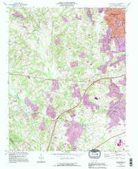 1993 Kannapolis1996 Print · USGSThe northern Piedmont area of North Carolina is captured here in the mid-1990s as suburban growth began to bridge the gaps between historic rural communities. Researchers can locate many local landmarks including Evans College, Fisher Town, and numerous family-linked churches like Shady Grove Chapel and Poplar Tent Ch.
 - 1993 Map of Cornelius, 1996 Print
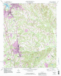 1993 Cornelius1996 Print · USGSNorthern Mecklenburg County witnessed significant growth in the early nineties, as seen in the expanding street grids of Cornelius and Huntersville. Researchers can locate old family landmarks like Bethel Cem and the campus of Davidson College.
 - 1993 Map of Enochville, 1996 Print
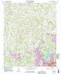 1993 Enochville1996 Print · USGSThe rural borders of Rowan and Cabarrus counties are captured here in the 1990s as longstanding communities began to expand. Genealogists can locate family landmarks such as McKnight Sch and Pleasant Grove Ch alongside Kannapolis Lake.
End of results
Showing maps 1-3 of 3
Top cities near Kannapolis
- Charlotte historical maps
- Concord historical maps
- Huntersville historical maps
- Mooresville historical maps
- Salisbury historical maps
- Cornelius historical maps
See more
Top neighborhoods of Kannapolis
- Heilmans Mill historical maps
- Glass historical maps
- Shady Brook historical maps
- West Brook historical maps
- Royal Oaks historical maps
- Centerview historical maps
See more
Frequently asked questions
- What are the different types of historical maps available for Kannapolis?
- What is the oldest map of Kannapolis?
- Where can I purchase historical maps of Kannapolis for my home or office?
- Where can I download high-res historical maps of Kannapolis?
- Are there historical topographic maps available for Kannapolis?
- Is there historical aerial imagery available for Kannapolis?
- Where are historical maps of Kannapolis sourced from?