1960s Maps of Chatham County, North Carolina
Explore 6 historic maps of Chatham County from the 1960s. These maps offer a rare glimpse into what life looked like during the 1960s — showing old roads, neighborhoods, homes, and landmarks that have changed or disappeared over time.
Whether you're researching your family's past, planning a metal detecting trip, or studying how Chatham County's landscape evolved across the 1960s, these high-resolution maps are a powerful tool for exploring the history of this region.
- Focus on a specific era: All maps on this page are from the 1960s, giving you a focused view of this time period.
- See what’s changed: Compare century-old streets, trails, and buildings to today's modern landscape using overlays and satellite layers.
- Research with precision: Use these maps for genealogy, historical research, land use analysis, or educational projects.
- View, download, or print: Maps are fully viewable online in high resolution, and can be downloaded or printed for your own records.
Start exploring Chatham County's history through authentic maps from the 1960s. This is your window into the past.
Chatham County, NC maps
(6)- 1968 Map of White Cross, 1969 Print
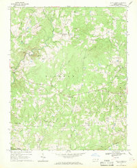 1968 White Cross1969 Print · USGSOrange County's rural crossroads and family settlements are captured here in the late sixties as the region maintained its agrarian character. Researchers can trace historic church sites like Alston Grove Ch and locate family landmarks from Thompson Mtn to Orange Grove.2 unique versions available
 - 1968 Map of Bynum, 1970 Print
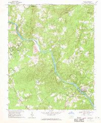 1968 Bynum1970 Print · USGSChatham County’s rural riverfront comes to life in this late sixties survey of the Haw River valley and its surrounding hill country. Genealogists and historians can trace family roots through a dense concentration of local landmarks like Cedar Grove Ch, Gum Springs, and Hunter.
 - 1968 Map of Coleridge, 1973 Print
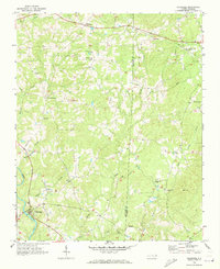 1968 Coleridge1973 Print · USGSRandolph and Chatham Counties are captured here in the late sixties as the rural Piedmont landscape maintained its traditional crossroads character. Genealogists and local historians can trace family-named sites like Browns Crossroads and local sanctuaries such as New Lambert Chapel and Jordan Grove Church.
 - 1968 Map of Bennett, 1973 Print
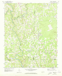 1968 Bennett1973 Print · USGSThe rural tri-county borderlands of Chatham, Randolph, and Moore counties are captured here in the late sixties. Researchers can trace family roots through numerous local landmarks like Maple Springs Ch, Mt Zion Ch, and the settlement at Bennett.
 - 1969 Map of Siler City, 1973 Print
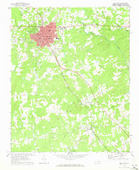 1969 Siler City1973 Print · USGSChatham County's industrial and rural character is on full display during the late sixties as Siler City expands along the rail lines. Local historians can trace family landmarks like Mt Vernon Springs Ch, the Old Railroad Grade, and Palmers Chapel.2 unique versions available
 - 1969 Map of New Hope Dam, 1973 Print
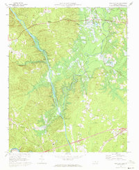 1969 New Hope Dam1973 Print · USGSChatham County is captured during the late sixties at a critical turning point as the New Hope Dam project begins to reshape the river valleys. Researchers can trace land tracts near Griffins Crossroads or locate old community hubs like Seaforth and Merry Oaks before the waters rose.2 unique versions available
End of results
Showing maps 1-6 of 6
Top cities of Chatham County
Frequently asked questions
- What are the different types of historical maps available for Chatham County?
- What is the oldest map of Chatham County?
- Where can I purchase historical maps of Chatham County for my home or office?
- Where can I download high-res historical maps of Chatham County?
- Are there historical topographic maps available for Chatham County?
- Is there historical aerial imagery available for Chatham County?
- Where are historical maps of Chatham County sourced from?