1990s Maps of Chatham County, North Carolina
Explore 7 historic maps of Chatham County from the 1990s. These maps offer a rare glimpse into what life looked like during the 1990s — showing old roads, neighborhoods, homes, and landmarks that have changed or disappeared over time.
Whether you're researching your family's past, planning a metal detecting trip, or studying how Chatham County's landscape evolved across the 1990s, these high-resolution maps are a powerful tool for exploring the history of this region.
- Focus on a specific era: All maps on this page are from the 1990s, giving you a focused view of this time period.
- See what’s changed: Compare century-old streets, trails, and buildings to today's modern landscape using overlays and satellite layers.
- Research with precision: Use these maps for genealogy, historical research, land use analysis, or educational projects.
- View, download, or print: Maps are fully viewable online in high resolution, and can be downloaded or printed for your own records.
Start exploring Chatham County's history through authentic maps from the 1990s. This is your window into the past.
Chatham County, NC maps
(7)- 1990 Map of Raleigh, 1991 Print
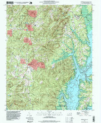
 1990 Raleigh1991 Print · USGSGreater Raleigh and the Research Triangle entered a period of significant suburban growth during the 1990s. Researchers can trace the development of towns like Fuquay-Varina and Wake Forest or locate landmarks such as the State Prison and Harris Reservoir.2 unique versions available
 - 1993 Map of Green Level, 1999 Print
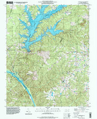
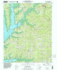 1993 Green Level1999 Print · USGSIn the early 1990s, the shores of B Everett Jordan Lake met a rural landscape of country churches and small crossroads. Researchers can trace family history through numerous landmarks including Martha Chapel, Mt Pisgah Ch, and the settlement of Green Level.
 - 1993 Map of New Hill, 1999 Print
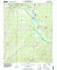
 1993 New Hill1999 Print · USGSWake and Chatham counties are shown during a period of transition in the early nineties, as large reservoirs reshaped the traditional rural landscape. Researchers can trace historic communities like Bonsal and Friendship alongside landmarks like Olive Chapel and the Power Plant.
 - 1993 Map of Merry Oaks, 1999 Print
 1993 Merry Oaks1999 Print · USGSIn the early 1990s, the landscape of central North Carolina was defined by the waters of B. Everett Jordan Lake. Researchers can trace the heritage of rural communities through numerous local landmarks, from Banks Chapel and Merry Oaks Ch to the crossroads at Wilsonville.
 - 1993 Map of Farrington, 1999 Print
 1993 Farrington1999 Print · USGSChatham County during the 1990s shows a landscape transformed by the waters of B. Everett Jordan Lake. Genealogists and local historians can trace family sites like Riggsbee Cemetery and old landmarks like Pritchards Mill Creek and Bells.
 - 1993 Map of Moncure, 1999 Print
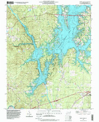
 1993 Moncure1999 Print · USGSThe headwaters of the Cape Fear River come into focus in the 1990s as the river-driven economy shifted toward modern utilities. Local historians can trace family roots through Rose Hill Cem and Memphis Ch or locate industrial sites like the Claypit near Brickhaven.
 - 1993 Map of Cokesbury, 1999 Print
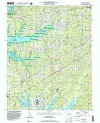
 1993 Cokesbury1999 Print · USGSHarnett and Wake counties meet in this 1990s landscape, where the rising waters of a major reservoir reach into rural crossroads. Researchers can trace family sites near Hollemans Crossroads, Prince Chapel, and the historic Cokesbury Ch.
End of results
Showing maps 1-7 of 7
Top cities of Chatham County
Frequently asked questions
- What are the different types of historical maps available for Chatham County?
- What is the oldest map of Chatham County?
- Where can I purchase historical maps of Chatham County for my home or office?
- Where can I download high-res historical maps of Chatham County?
- Are there historical topographic maps available for Chatham County?
- Is there historical aerial imagery available for Chatham County?
- Where are historical maps of Chatham County sourced from?