1980s Maps of Cleveland County, North Carolina
Explore 7 historic maps of Cleveland County from the 1980s. These maps offer a rare glimpse into what life looked like during the 1980s — showing old roads, neighborhoods, homes, and landmarks that have changed or disappeared over time.
Whether you're researching your family's past, planning a metal detecting trip, or studying how Cleveland County's landscape evolved across the 1980s, these high-resolution maps are a powerful tool for exploring the history of this region.
- Focus on a specific era: All maps on this page are from the 1980s, giving you a focused view of this time period.
- See what’s changed: Compare century-old streets, trails, and buildings to today's modern landscape using overlays and satellite layers.
- Research with precision: Use these maps for genealogy, historical research, land use analysis, or educational projects.
- View, download, or print: Maps are fully viewable online in high resolution, and can be downloaded or printed for your own records.
Start exploring Cleveland County's history through authentic maps from the 1980s. This is your window into the past.
Cleveland County, NC maps
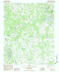
(7)- 1982 Map of Polkville, 1983 Print
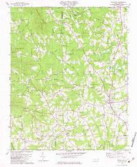 1982 Polkville1983 Print · USGSWestern Cleveland County comes into focus in the early 1980s as the First Broad River snakes through a landscape of family-named mountains and rural crossroads. Genealogists and local historians can locate many rural landmarks including Lee Chapel, White Oak Springs Ch, and the settlement of New House.
 - 1982 Map of Boiling Springs North, 1983 Print
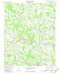 1982 Boiling Springs North1983 Print · USGSIn the early 1980s, this portion of Cleveland and Rutherford counties centered on the rail corridors and rural communities. Genealogists can trace family landmarks like McBrayer Cem, Goodey Grove Ch, and the McKinney Mill Bridge.
 - 1982 Map of Lawndale, 1983 Print
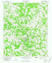 1982 Lawndale1983 Print · USGSCleveland County's rural heartland is captured here in the early eighties as a landscape of tight-knit communities and family-named landmarks. Genealogists can trace local roots through numerous sites like Rose Hill Cem, Burns High Sch, and the riverside settlement of Lawndale.
 - 1983 Map of Shelby
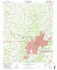 1983 Shelby1983 Print · USGSIn the early eighties, Shelby flourished as a textile and transit hub where the Seaboard and Southern railroads meet. Genealogists and local historians can trace family-named sites and vanished landmarks like Shanghai, Mulls Chapel, and Twelve Oaks Academy.2 unique versions available
 - 1983 Map of Chesnee
 1983 Chesnee1983 Print · USGSThe Carolina borderlands near Chesnee and Cliffside are captured here in the early eighties as the textile and agricultural landscape evolved. Genealogists and local historians can locate many rural landmarks, from the Cowpens National Battlefield to Jerusalem Ch and Chase High Sch.
 - 1986 Map of Hickory
 1986 Hickory1986 Print · USGSWestern North Carolina's foothills are seen here in the mid-eighties as textile and furniture towns flourished along the river. Trace the development of Hickory and Lenoir or locate local landmarks like Burke Chapel, Saw Mills, and Rhodhiss Lake.3 unique versions available
 - 1986 Map of Gastonia
 1986 Gastonia1986 Print · USGSThe Carolina Piedmont in the mid-eighties shows a landscape shaped by Revolutionary War history and the textile industry. Trace the footprints of early battles at Kings Mountain National Military Park and locate depots along the Southern Railway in Shelby and Gastonia.
End of results
Showing maps 1-7 of 7
Top cities of Cleveland County
- Shelby historical maps
- Kings Mountain historical maps
- Boiling Springs historical maps
- Belwood historical maps
- Kingstown historical maps
- Grover historical maps
See more
Frequently asked questions
- What are the different types of historical maps available for Cleveland County?
- What is the oldest map of Cleveland County?
- Where can I purchase historical maps of Cleveland County for my home or office?
- Where can I download high-res historical maps of Cleveland County?
- Are there historical topographic maps available for Cleveland County?
- Is there historical aerial imagery available for Cleveland County?
- Where are historical maps of Cleveland County sourced from?