2000-2009 Maps of Cleveland County, North Carolina
Explore 7 historic maps of Cleveland County from 2000-2009. These maps offer a rare glimpse into what life looked like during the 2000s — showing old roads, neighborhoods, homes, and landmarks that have changed or disappeared over time.
Whether you're researching your family's past, planning a metal detecting trip, or studying how Cleveland County's landscape evolved across the 2000s, these high-resolution maps are a powerful tool for exploring the history of this region.
- Focus on a specific era: All maps on this page are from the 2000s, giving you a focused view of this time period.
- See what’s changed: Compare century-old streets, trails, and buildings to today's modern landscape using overlays and satellite layers.
- Research with precision: Use these maps for genealogy, historical research, land use analysis, or educational projects.
- View, download, or print: Maps are fully viewable online in high resolution, and can be downloaded or printed for your own records.
Start exploring Cleveland County's history through authentic maps from the 2000s. This is your window into the past.
Cleveland County, NC maps
(7)- 2002 Map of Bessemer City, 2003 Print
 2002 Bessemer City2003 Print · USGSBessemer City and the industrial corridor of Gaston County are captured here at the turn of the millennium. Researchers can trace the footprint of active Mines and Tailings Ponds alongside landmarks like Ebenezer Ch and Chestnut Ridge.
 - 2002 Map of Polkville, 2003 Print
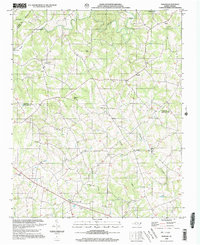
 2002 Polkville2003 Print · USGSThe foothills of Cleveland and Rutherford counties appear here at the start of the twenty-first century as a landscape of established family farms and rural crossroads. Genealogists can locate legacy sites like Lattimore Cem, White Oak Springs Ch, and the small community of Polkville.
 - 2002 Map of Banoak, 2003 Print
 2002 Banoak2003 Print · USGSThe rural Piedmont of Lincoln and Catawba counties is captured here at the turn of the millennium. Local historians can trace family roots through numerous sites like Cat Square, Hulls Crossroads, and the T Chapman Cem.
 - 2002 Map of Cherryville, 2003 Print
 2002 Cherryville2003 Print · USGSThe crossroads and creeks of the Gaston and Lincoln county borderlands are captured here at the start of the millennium. Genealogists can trace family footprints through numerous community landmarks, including Beam Mill, Bess Chapel, and Zion Hill Ch.
 - 2002 Map of Shelby, 2003 Print
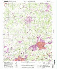
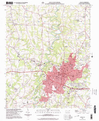 2002 Shelby2003 Print · USGSShelby and its surrounding Cleveland County townships are shown here at the start of the millennium. Local researchers can locate numerous community landmarks such as Eskridge Grove Ch, the Drive-in Theater, and the Shelby Municipal Airport.
 - 2002 Map of Lawndale, 2003 Print
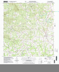
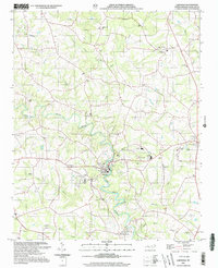 2002 Lawndale2003 Print · USGSCleveland County at the dawn of the millennium shows a landscape of river-bend towns and rural crossroads. Researchers can trace local heritage through numerous landmarks like Lawndale, the Burns High Sch campus, and Palm Tree Cem.
 - 2002 Map of Boiling Springs North, 2003 Print
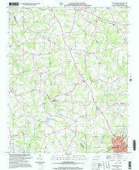
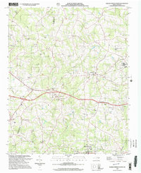 2002 Boiling Springs North2003 Print · USGSCleveland and Rutherford Counties are documented here at the opening of the millennium, showing a landscape shaped by rural crossroads and small-town growth. Genealogists and local historians can locate family landmarks such as the Beam Cem, the McKinney Mill Bridge, and old community centers like Mooresboro.
End of results
Showing maps 1-7 of 7
Top cities of Cleveland County
- Shelby historical maps
- Kings Mountain historical maps
- Boiling Springs historical maps
- Belwood historical maps
- Kingstown historical maps
- Grover historical maps
See more
Frequently asked questions
- What are the different types of historical maps available for Cleveland County?
- What is the oldest map of Cleveland County?
- Where can I purchase historical maps of Cleveland County for my home or office?
- Where can I download high-res historical maps of Cleveland County?
- Are there historical topographic maps available for Cleveland County?
- Is there historical aerial imagery available for Cleveland County?
- Where are historical maps of Cleveland County sourced from?