1960s Maps of Duplin County, North Carolina
Explore 2 historic maps of Duplin County from the 1960s. These maps offer a rare glimpse into what life looked like during the 1960s — showing old roads, neighborhoods, homes, and landmarks that have changed or disappeared over time.
Whether you're researching your family's past, planning a metal detecting trip, or studying how Duplin County's landscape evolved across the 1960s, these high-resolution maps are a powerful tool for exploring the history of this region.
- Focus on a specific era: All maps on this page are from the 1960s, giving you a focused view of this time period.
- See what’s changed: Compare century-old streets, trails, and buildings to today's modern landscape using overlays and satellite layers.
- Research with precision: Use these maps for genealogy, historical research, land use analysis, or educational projects.
- View, download, or print: Maps are fully viewable online in high resolution, and can be downloaded or printed for your own records.
Start exploring Duplin County's history through authentic maps from the 1960s. This is your window into the past.
Duplin County, NC maps
(2)- 1962 Map of Rose Hill, 1964 Print
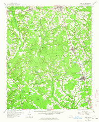 1962 Rose Hill1964 Print · USGSCoastal plain life in the early sixties centers on the rail-aligned towns of Rose Hill and Warsaw. Genealogists and local historians can locate dozens of country churches and schools, from Holly Grove Ch to the Williams Sch, alongside the Rose Hill Speedway.
 - 1965 Map of Richlands
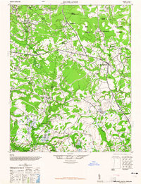 1965 Richlands1965 Print · USGSRichlands and the surrounding coastal plains of Onslow County are captured here in the mid-sixties as rural communities were evolving. Genealogists can locate family-named landmarks and institutions like Huffmantown, Potters Hill Sch, and Bethany Chapel.
End of results
Showing maps 1-2 of 2
Top cities of Duplin County
- Warsaw historical maps
- Rose Hill historical maps
- Beulaville historical maps
- Magnolia historical maps
- Kenansville historical maps
- Faison historical maps
See more
Frequently asked questions
- What are the different types of historical maps available for Duplin County?
- What is the oldest map of Duplin County?
- Where can I purchase historical maps of Duplin County for my home or office?
- Where can I download high-res historical maps of Duplin County?
- Are there historical topographic maps available for Duplin County?
- Is there historical aerial imagery available for Duplin County?
- Where are historical maps of Duplin County sourced from?