1900s (20th Century) Maps of Bear Grass, North Carolina
Explore 7 historic maps of Bear Grass from the 1900s (20th Century). These maps offer a rare glimpse into what life looked like during the 1900s — showing old roads, neighborhoods, homes, and landmarks that have changed or disappeared over time.
Whether you're researching your family's past, planning a metal detecting trip, or studying how Bear Grass's landscape evolved across the 1900s, these high-resolution maps are a powerful tool for exploring the history of this region.
- Focus on a specific era: All maps on this page are from the 1900s, giving you a focused view of this time period.
- See what’s changed: Compare century-old streets, trails, and buildings to today's modern landscape using overlays and satellite layers.
- Research with precision: Use these maps for genealogy, historical research, land use analysis, or educational projects.
- View, download, or print: Maps are fully viewable online in high resolution, and can be downloaded or printed for your own records.
Start exploring Bear Grass's history through authentic maps from the 1900s. This is your window into the past.
Bear Grass, NC maps
(7)- 1901 Map of Williamston, 1972 Print
 1901 Williamston1972 Print · USGSThe Roanoke River basin at the turn of the century shows a thriving network of steamboat landings and new rail lines. Genealogists and researchers can trace the river economy through Spellers Ferry Landing, Grabtown, and the Atlantic Coast Line R. R.
 - 1902 Map of Williamston, 1944 Print
 1902 Williamston1944 Print · USGSMartin County’s riverfront and rail corridors are frozen in time here at the dawn of the twentieth century. Genealogists and local historians can trace family roots through landings like Spellers Ferry Landing or settlements at Everetts and Goldpoint.
 - 1953 Map of Rocky Mount, 1964 Print
 1953 Rocky Mount1964 Print · USGSEastern North Carolina in the mid-fifties is defined by its deep river basins and the vast wetlands of the Tidewater. Genealogists can trace family roots through hubs like Kinston and New Bern or explore the wilderness of Pettigrew State Park and Lake Mattamuskeet.4 unique versions available
 - 1954 Map of Rocky Mount
 1954 Rocky Mount1954 Print · USGSEastern North Carolina is mapped in the mid-fifties, showing a landscape of sounds, swamps, and steam-era rail lines. Genealogists can trace the rural road networks and rail spurs connecting towns like Tarboro, Greenville, and the remote Columbia.
 - 1981 Map of Robersonsville East, 1982 Print
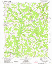 1981 Robersonsville East1982 Print · USGSThe rural landscape of Martin County is captured here in the early eighties, showcasing the rail-reliant towns of Robersonville and Everetts. Local researchers can trace family roots through numerous sites like Martin Academy, Willow Chapel, and Bear Grass.
 - 1982 Map of Williamston
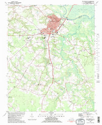 1982 Williamston1982 Print · USGSWilliamston and the surrounding Martin County countryside appear in the early 1980s as a hub of river commerce and rail transit. Researchers can trace family sites from Bear Grass to Woodland Acres, locating Staton-Biggs Cem and Riddicks Grove Ch.
 - 1985 Map of Rocky Mount
 1985 Rocky Mount1985 Print · USGSThe eastern North Carolina coastal plain in the mid-eighties shows a landscape defined by its river-and-rail heritage. Genealogists and local historians can trace the development of Rocky Mount, Greenville, and Wilson, or locate landmarks like East Carolina University and the Voice of America site.2 unique versions available
End of results
Showing maps 1-7 of 7
Top cities near Bear Grass
- Greenville historical maps
- Washington historical maps
- Williamston historical maps
- Windsor historical maps
- Robersonville historical maps
- Hamilton historical maps
See more
Frequently asked questions
- What are the different types of historical maps available for Bear Grass?
- What is the oldest map of Bear Grass?
- Where can I purchase historical maps of Bear Grass for my home or office?
- Where can I download high-res historical maps of Bear Grass?
- Are there historical topographic maps available for Bear Grass?
- Is there historical aerial imagery available for Bear Grass?
- Where are historical maps of Bear Grass sourced from?