1900s (20th Century) Maps of Moore County, North Carolina
Explore 52 historic maps of Moore County from the 1900s (20th Century). These maps offer a rare glimpse into what life looked like during the 1900s — showing old roads, neighborhoods, homes, and landmarks that have changed or disappeared over time.
Whether you're researching your family's past, planning a metal detecting trip, or studying how Moore County's landscape evolved across the 1900s, these high-resolution maps are a powerful tool for exploring the history of this region.
- Focus on a specific era: All maps on this page are from the 1900s, giving you a focused view of this time period.
- See what’s changed: Compare century-old streets, trails, and buildings to today's modern landscape using overlays and satellite layers.
- Research with precision: Use these maps for genealogy, historical research, land use analysis, or educational projects.
- View, download, or print: Maps are fully viewable online in high resolution, and can be downloaded or printed for your own records.
Start exploring Moore County's history through authentic maps from the 1900s. This is your window into the past.
Moore County, NC maps
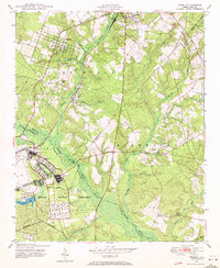
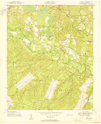
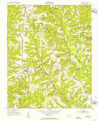
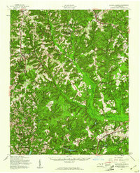
(52)- 1942 Map of Troy
 1942 Troy1942 Print · USGSMid-century central North Carolina comes alive through this 1940s survey of the rail-linked towns between the Uwharrie hills and the Sandhills. Trace the historic Norfolk Southern line through Troy, Star, and Biscoe, or locate the Morrison Training School and local springs.
 - 1948 Map of Southern Pines, 1954 Print
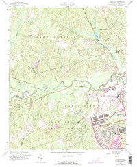
 1948 Southern Pines1954 Print · USGSThe North Carolina Sandhills were a hub of transit and military expansion just after the war. This survey allows researchers to trace family landmarks like St Mathews Ch and Taylor Town or map the early footprints of Fort Bragg and Camp Mackall.
 - 1948 Map of Clifdale, 1967 Print
 1948 Clifdale1967 Print · USGSHoke and Cumberland Counties appear just after World War II, showing the vast footprint of the Fort Bragg Military Reservation. Local historians can trace old community landmarks like Longstreet Church, the Atlantic Coast Line railroad, and the Frys Mission School.
 - 1948 Map of Pinebluff, 1972 Print
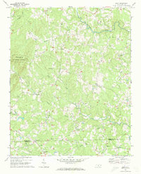
 1948 Pinebluff1972 Print · USGSThe Sand Hills of Moore and Richmond counties are shown here just after the war, where military expansions met rural North Carolina life. Genealogists and researchers can trace the Seaboard Air Line through Addor, find family roots at Silver Springs Cemetery, and locate the old McFarland Sch.3 unique versions available
 - 1949 Map of West End, 1953 Print
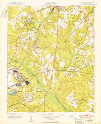
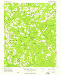
 1949 West End1953 Print · USGSMoore County at the close of the 1940s reveals a landscape of growing residential pockets and established rail corridors. Genealogists and historians can trace community roots through the West End settlement, local churches like McDonalds Chapel, and the historic Jackson Springs area.3 unique versions available
 - 1949 Map of Hoffman, 1953 Print
 1949 Hoffman1953 Print · USGSHoffman and the surrounding Sand Hills of Richmond County are captured here just after the war, showing the expansion of military and conservation lands. Researchers can trace the Seaboard Air Line railroad through the heart of town or locate rural landmarks like McNir Chapel and Watson Cem.3 unique versions available
 - 1949 Map of Jackson Springs, 1954 Print
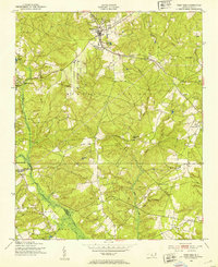
 1949 Jackson Springs1954 Print · USGSThe North Carolina Sandhills were undergoing a transition in the late 1940s as military footprints expanded alongside rural farming communities. Genealogists and historians can trace the foundations of Camp Mackall and find local landmarks like the Morrison Training Sch and Jackson Springs.
 - 1950 Map of Lobelia
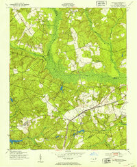
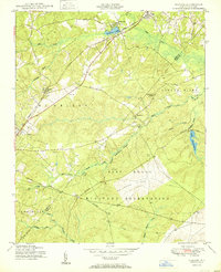
 1950 Lobelia1950 Print · USGSThe North Carolina Sandhills met military expansion during the mid-century as the Fort Bragg boundary reached northward. Genealogists can trace early landmarks like Frys Mission School, Lobelia, and Cypress Church along the Little River.
 - 1950 Map of Pine Bluff
 1950 Pine Bluff1950 Print · USGSThe North Carolina Sandhills are captured here at the start of the 1950s, showing a landscape defined by military training and the railroad. Genealogists and local historians can trace family sites like Silver Springs Cemetery, the McFarland Sch, and the wartime infrastructure of Camp Mackall.
 - 1950 Map of Niagara
 1950 Niagara1950 Print · USGSIn the Sand Hills during the late 1940s, the rural landscapes of Moore and Hoke Counties were defined by rail corridors and expanding military grounds. Researchers can trace family sites like McCrimmons Chapel, the Goins Cem, and the small rail settlements of Niagara and Manly.
 - 1950 Map of Southern Pines
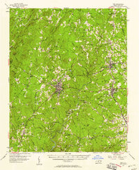
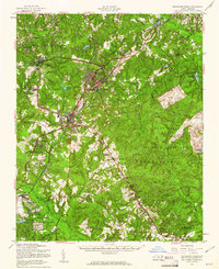
 1950 Southern Pines1950 Print · USGSMoore County transitioned from rural timberland to a premier resort hub during the mid-century, as shown in this detailed survey of the Sandhills. Researchers can trace the development of Pinehurst and Southern Pines, locating landmarks like the Village Chapel, The Ark Sch, and Bethesda Church.
 - 1950 Map of Norman, 1953 Print
 1950 Norman1953 Print · USGSThe town of Norman and the surrounding Sandhills region appear here in the early fifties, showing a rural landscape tied to the Norfolk Southern railroad. Trace family sites at Leakes Sch, the Williamson Cem, or settlements like Wind Blow and Derby.2 unique versions available
 - 1951 Map of Clifdale
 1951 Clifdale1951 Print · USGSMid-century Hoke and Cumberland counties are defined here by the growth of the Fort Bragg Military Reservation. Genealogists and historians can trace older community landmarks like Longstreet Church, the Aberdeen & Rockfish RR, and the Frys Mission School.
 - 1953 Map of Raleigh, 1965 Print
 1953 Raleigh1965 Print · USGSCentral North Carolina in the early sixties shows a landscape of growing towns and military hubs before the full expansion of the interstate system. Genealogists can trace family footprints across the Piedmont through Wake Forest, Siler City, and the large Fort Bragg Military Reservation.4 unique versions available
 - 1954 Map of Raleigh
 1954 Raleigh1954 Print · USGSThe North Carolina Piedmont and Sandhills are captured in the mid-fifties during a period of steady regional growth. Genealogists and historians can trace the development of towns like Siler City or locate landmarks such as Falls of Neuse and Camp Mackall.
 - 1957 Map of Murchisontown, 1958 Print
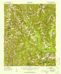
 1957 Murchisontown1958 Print · USGSIn the late fifties, the rural borders of Harnett, Lee, and Moore Counties remained a landscape of timber and tobacco farms tied together by country churches. Researchers can locate numerous local landmarks including McIver Sch, Murchison Chapel, and an ancient Indian Mound near Huckleberry Pond.2 unique versions available
 - 1957 Map of Troy, 1958 Print
 1957 Troy1958 Print · USGSMontgomery County was a landscape of river-valley settlements and rural industry in the late fifties. Genealogists and historians can trace family-named landmarks and remote communities like Ophir or Flint Hill, along with dozens of local steeples including Clarks Grove Ch and Ropers Grove Ch.2 unique versions available
 - 1957 Map of Asheboro, 1959 Print
 1957 Asheboro1959 Print · USGSRandolph County's rural and industrial character is captured here during the late fifties, centered on the growing town of Asheboro. Researchers can trace old family roots at Whynot, locate the State Prison (Camp 406), or find numerous rural landmarks like Tabernacle Sch and Callicutts Ch.2 unique versions available
 - 1957 Map of Southern Pines, 1960 Print
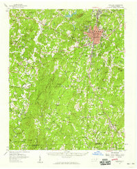
 1957 Southern Pines1960 Print · USGSThe North Carolina Sand Hills come into focus in the late fifties, centered on the growing resorts and rail hubs of Moore County. Researchers can trace historic lineages through local landmarks like Old Notre Dame Academy, McCrimmons Chapel, and the Silver Spring Cem.
 - 1957 Map of Southern Pines, 1960 Print
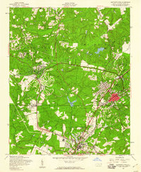 1957 Southern Pines1960 Print · USGSThe Sandhills of Moore County are shown here in the late fifties as the resort and rail hub centers reach their mid-century form. Researchers can trace the development of Pinehurst and Southern Pines, identifying landmarks like the Pinehurst Trotting Track, Village Chapel, and the Seaboard Air Line railroad.4 unique versions available
 - 1957 Map of Niagara, 1960 Print
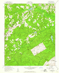 1957 Niagara1960 Print · USGSMoore County in the late fifties shows the steady influence of the railroad and the expansion of the Fort Bragg Military Reservation. Researchers can locate specific sites like the Old Notre Dame Academy, Gains Cem, and the village of Manly.5 unique versions available
 - 1957 Map of Lobelia, 1960 Print
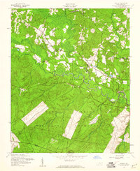 1957 Lobelia1960 Print · USGSNorth Carolina's Sandhills region is captured here during the late 1950s as military and civilian landscapes intersected near the Little River. Genealogists and local historians can trace family locations near Lobelia and Frys Chapel or locate mid-century landmarks like Ranger Station No 2.5 unique versions available
 - 1957 Map of Jackson Springs, 1961 Print
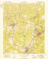
 1957 Jackson Springs1961 Print · USGSMoore and Richmond counties in the late 1950s reflect a mix of military presence and quiet rural life. Researchers can trace families near Jackson Springs, locate the old Hoffman High Sch, or find rural landmarks like Marcus Grove Ch and Millstone Lake.
 - 1957 Map of Overhills, 1973 Print
 1957 Overhills1973 Print · USGSCumberland and Harnett Counties are shown during a period of significant military expansion in the mid-fifties. Genealogists and historians can trace the development of Pope Air Force Base, locate the Murray Sch, or follow the Seaboard Coast Line through Overhills.
 - 1968 Map of Erect, 1973 Print
 1968 Erect1973 Print · USGSNorth Carolina's Piedmont hills are revealed here in the late sixties, highlighting the rural pottery and farming communities of Randolph and Moore counties. Genealogists can locate family landmarks like Jugtown, Yow Mill, and Needhams Grove Ch.
Showing maps 1-25 of 52
Top cities of Moore County
- Pinehurst historical maps
- Southern Pines historical maps
- Aberdeen historical maps
- Seven Lakes historical maps
- Whispering Pines historical maps
- Carthage historical maps
See more
Frequently asked questions
- What are the different types of historical maps available for Moore County?
- What is the oldest map of Moore County?
- Where can I purchase historical maps of Moore County for my home or office?
- Where can I download high-res historical maps of Moore County?
- Are there historical topographic maps available for Moore County?
- Is there historical aerial imagery available for Moore County?
- Where are historical maps of Moore County sourced from?