1970s Maps of Dortches, North Carolina
Explore 3 historic maps of Dortches from the 1970s. These maps offer a rare glimpse into what life looked like during the 1970s — showing old roads, neighborhoods, homes, and landmarks that have changed or disappeared over time.
Whether you're researching your family's past, planning a metal detecting trip, or studying how Dortches's landscape evolved across the 1970s, these high-resolution maps are a powerful tool for exploring the history of this region.
- Focus on a specific era: All maps on this page are from the 1970s, giving you a focused view of this time period.
- See what’s changed: Compare century-old streets, trails, and buildings to today's modern landscape using overlays and satellite layers.
- Research with precision: Use these maps for genealogy, historical research, land use analysis, or educational projects.
- View, download, or print: Maps are fully viewable online in high resolution, and can be downloaded or printed for your own records.
Start exploring Dortches's history through authentic maps from the 1970s. This is your window into the past.
Dortches, NC maps
(3)- 1975 Map of Rocky Mount, 1978 Print
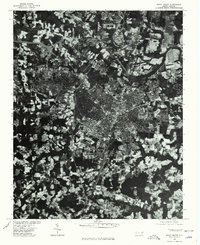 1975 Rocky Mount1978 Print · USGSRocky Mount and the surrounding Nash County countryside are captured in this mid-1970s aerial survey. Local historians and genealogists can trace the footprint of the city alongside nearby settlements like Sharpsburg and Battleboro as they appeared decades ago.
 - 1977 Map of Nashville
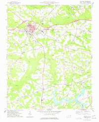 1977 Nashville1977 Print · USGSNash County in the late seventies is centered on the growing town of Nashville, where rail lines and regional schools meet the surrounding farmland. Researchers can trace rural lineages through numerous country churches and cemeteries, such as Taylors Chapel, Sapony Ch, and Oakland Cem.
 - 1977 Map of Rocky Mount
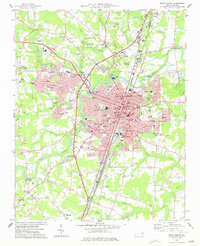 1977 Rocky Mount1977 Print · USGSRocky Mount is captured in the late seventies as it expanded across the Nash and Edgecombe county lines. Researchers can trace neighborhood growth through Woodlawn and Sunset or locate local landmarks like Buck Leonard Park and the Drive-in Theater.
End of results
Showing maps 1-3 of 3
Top cities near Dortches
- Rocky Mount historical maps
- Wilson historical maps
- Nashville historical maps
- Red Oak historical maps
- Enfield historical maps
- Sharpsburg historical maps
See more
Frequently asked questions
- What are the different types of historical maps available for Dortches?
- What is the oldest map of Dortches?
- Where can I purchase historical maps of Dortches for my home or office?
- Where can I download high-res historical maps of Dortches?
- Are there historical topographic maps available for Dortches?
- Is there historical aerial imagery available for Dortches?
- Where are historical maps of Dortches sourced from?