1990s Maps of Topsail Beach, North Carolina
Explore 4 historic maps of Topsail Beach from the 1990s. These maps offer a rare glimpse into what life looked like during the 1990s — showing old roads, neighborhoods, homes, and landmarks that have changed or disappeared over time.
Whether you're researching your family's past, planning a metal detecting trip, or studying how Topsail Beach's landscape evolved across the 1990s, these high-resolution maps are a powerful tool for exploring the history of this region.
- Focus on a specific era: All maps on this page are from the 1990s, giving you a focused view of this time period.
- See what’s changed: Compare century-old streets, trails, and buildings to today's modern landscape using overlays and satellite layers.
- Research with precision: Use these maps for genealogy, historical research, land use analysis, or educational projects.
- View, download, or print: Maps are fully viewable online in high resolution, and can be downloaded or printed for your own records.
Start exploring Topsail Beach's history through authentic maps from the 1990s. This is your window into the past.
Topsail Beach, NC maps
(4)- 1990 Map of Wilmington
 1990 Wilmington1990 Print · USGSThe North Carolina coast in the early nineties reveals a landscape defined by the convergence of the Cape Fear River and the Atlantic shore. Genealogists and historians can trace suburban growth and maritime infrastructure from the inland Kendall Chapel to coastal hubs like Wrightsville Beach and Carolina Beach.
 - 1997 Map of Holly Ridge, 1999 Print
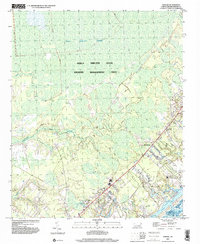
 1997 Holly Ridge1999 Print · USGSCoastal North Carolina during the late nineties shows a landscape of barrier island growth and protected inland wetlands. Genealogists can trace family connections through numerous landings like Edens Landing and rural churches such as Stump Sound Ch.
 - 1997 Map of Topsail, 2000 Print
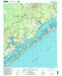
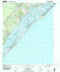
 1997 Topsail2000 Print · USGSThe Pender County coast and its expansive wetlands were undergoing subtle changes at the end of the century. Genealogists and historians can trace old community landmarks like Blakes Chapel, St Johns Ch, and the rural settlement of Woodside.
 - 1997 Map of Hampstead, 2000 Print
 1997 Hampstead2000 Print · USGSCoastal Pender County and its barrier islands come into sharp focus in the late nineties as the region's shoreline communities grew. Genealogists and researchers can trace local landmarks like St Johns Ch, Brown Town, and the docks at Kings Landing.
End of results
Showing maps 1-4 of 4
Top cities near Topsail Beach
- Wilmington historical maps
- Wrightsville Beach historical maps
- Surf City historical maps
- Holly Ridge historical maps
- North Topsail Beach historical maps
- Hampstead historical maps
Frequently asked questions
- What are the different types of historical maps available for Topsail Beach?
- What is the oldest map of Topsail Beach?
- Where can I purchase historical maps of Topsail Beach for my home or office?
- Where can I download high-res historical maps of Topsail Beach?
- Are there historical topographic maps available for Topsail Beach?
- Is there historical aerial imagery available for Topsail Beach?
- Where are historical maps of Topsail Beach sourced from?