1980s Maps of Topsail Beach, North Carolina
Explore 4 historic maps of Topsail Beach from the 1980s. These maps offer a rare glimpse into what life looked like during the 1980s — showing old roads, neighborhoods, homes, and landmarks that have changed or disappeared over time.
Whether you're researching your family's past, planning a metal detecting trip, or studying how Topsail Beach's landscape evolved across the 1980s, these high-resolution maps are a powerful tool for exploring the history of this region.
- Focus on a specific era: All maps on this page are from the 1980s, giving you a focused view of this time period.
- See what’s changed: Compare century-old streets, trails, and buildings to today's modern landscape using overlays and satellite layers.
- Research with precision: Use these maps for genealogy, historical research, land use analysis, or educational projects.
- View, download, or print: Maps are fully viewable online in high resolution, and can be downloaded or printed for your own records.
Start exploring Topsail Beach's history through authentic maps from the 1980s. This is your window into the past.
Topsail Beach, NC maps
(4)- 1980 Map of Topsail, 1985 Print
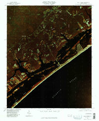
 1980 Topsail1985 Print · USGSThe North Carolina coast at the dawn of the eighties reveals a sharp divide between the massive Holly Shelter Swamp and burgeoning shoreward communities. Trace the early footprints of Topsail and Woodside as they expand toward the waters of Topsail Sound.2 unique versions available
 - 1980 Map of Holly Ridge, 1985 Print
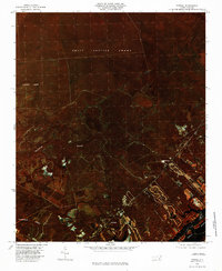
 1980 Holly Ridge1985 Print · USGSThe Onslow County coast in the early eighties shows the rhythmic patterns of barrier island life and inland timbering. Genealogists and historians can locate old coastal sites like Morris Landing and Watts Landing along Topsail Sound.
 - 1980 Map of Hampstead, 1986 Print
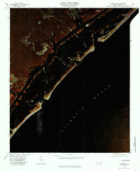 1980 Hampstead1986 Print · USGSThe Pender County coastline and barrier islands are seen here in the early eighties as residential development began to expand around Hampstead. Genealogists and historians can trace the inland settlements of Browntown and the coastal landing at Kings Landing.
 - 1984 Map of Wilmington, 1985 Print
 1984 Wilmington1985 Print · USGSThe Lower Cape Fear region is shown here in the mid-1980s as the coastal corridor between Wilmington and the barrier islands experienced significant development. Researchers can trace historic river landings, the winding Intracoastal Waterway, and established communities from Castle Hayne to Topsail Beach.
End of results
Showing maps 1-4 of 4
Top cities near Topsail Beach
- Wilmington historical maps
- Wrightsville Beach historical maps
- Surf City historical maps
- Holly Ridge historical maps
- North Topsail Beach historical maps
- Hampstead historical maps
Frequently asked questions
- What are the different types of historical maps available for Topsail Beach?
- What is the oldest map of Topsail Beach?
- Where can I purchase historical maps of Topsail Beach for my home or office?
- Where can I download high-res historical maps of Topsail Beach?
- Are there historical topographic maps available for Topsail Beach?
- Is there historical aerial imagery available for Topsail Beach?
- Where are historical maps of Topsail Beach sourced from?